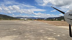
Juvai Semaring Airport

Last updated
Yuvai Semaring Airport

Bandar Udara Juvai Semaring
Long Bawan Airport.jpg
Summary
Airport typePublic
Serves Long Bawan, North Kalimantan, Indonesia
Time zone WITA (UTC+08:00)
Elevation  AMSL 762 m / 2,500 ft
Coordinates 03°54′11.2″N115°41′31.2″E / 3.903111°N 115.692000°E / 3.903111; 115.692000
Map
Borneo Locator Topography.png
Airplane silhouette.svg
LBW
Location in Kalimantan
Runways
Direction LengthSurface
mft
04/229002,953
Sources: [1] [2]

Juvai Semaring Airport (Indonesian : Bandar Udara Juvai Semaring [1] ) ( IATA : LBW, ICAO : WAQJ previously WRLB) is serves Long Bawan, located in the province of North Kalimantan in Indonesia. [2] It is also known as Long Bawan Airport.

Contents

Location

The airport is located in the village of Long Bawan in North Kalimantan, which is located near the border with Malaysia. [3]

Facilities

The airport is at an elevation of 762 metres (2,500 ft) above mean sea level. It has one runway designated 04/22 which measures 900 by 30 metres (2,953 ft × 98 ft). [1]

Airlines and destinations

AirlinesDestinations
Susi Air Malinau, Nunukan, Tarakan [4]

References

  1. 1 2 3 "Yuvai Semaring (LBW / WAQJ)". Directorate General of Civil Aviation, Ministry of Transportation, Republic of Indonesia. Archived from the original on 10 September 2018. Retrieved 6 June 2010.
  2. 1 2 Airport information for Long Bawan, East Kalimantan, Indonesia - Juvai Semaring (WRLB / LBW) at Great Circle Mapper.
  3. "Construction of roads near Indonesia-Malaysia border to continue: govt". Antara News. 29 July 2020. Retrieved 23 February 2023.
  4. "--- SUSI AIR -- Passenger and Cargo Aircraft Charter". Archived from the original on 2012-06-20. Retrieved 2012-06-23.