
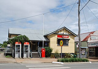
Esk is a rural town and locality in the Somerset Region in South East Queensland, Australia. In the 2021 census, the locality of Esk had a population of 1,641 people.

Prenzlau is a rural locality in the Somerset Region, Queensland, Australia. In the 2021 census, Prenzlau had a population of 408 people.
Lowood is a rural town and locality in the Somerset Region, Queensland, Australia. In the 2021 census, the locality of Lowood had a population of 4,082 people.
Glamorgan Vale is a rural town and locality in the Somerset Region, Queensland, Australia. In the 2021 census, the locality of Glamorgan Vale had a population of 384 people.
Minden is a rural town and locality in the Somerset Region, Queensland, Australia. The town is 64 kilometres (40 mi) west of the state capital, Brisbane. In the 2021 census, the locality of Minden had a population of 1,227 people.

Tarampa is a rural locality in the Somerset Region, Queensland, Australia. In the 2021 census, Tarampa had a population of 287 people.
Clarendon is a rural locality in the Somerset Region, Queensland, Australia. In the 2021 census, Clarendon had a population of 232 people.

Withcott is a rural town and locality in the Lockyer Valley Region, Queensland, Australia. In the 2021 census, the locality of Withcott had a population of 2,067 people.

Plainland is a town in the Lockyer Valley Region, Queensland, Australia. In the 2021 census, Plainland had a population of 1,930 people, an increase of 21% from the 2016 census.
Hatton Vale is a rural locality in the Lockyer Valley Region, Queensland, Australia. In the 2021 census, Hatton Vale had a population of 1,555 people.

Lockrose is a rural locality split between the Lockyer Valley Region and Somerset Region of Queensland, Australia. In the 2021 census, Lockrose had a population of 564 people.

Atkinsons Dam is a rural locality in the Somerset Region, Queensland, Australia. In the 2021 census, Atkinsons Dam had a population of 191 people.

Lower Tenthill is a rural locality in the Lockyer Valley Region, Queensland, Australia. In the 2021 census, Lower Tenthill had a population of 236 people.

Glenore Grove is a rural locality in the Lockyer Valley Region, Queensland, Australia. In the 2021 census, Glenore Grove had a population of 953 people.
Lake Clarendon is a rural locality in the Lockyer Valley Region, Queensland, Australia. In the 2021 census, Lake Clarendon had a population of 294 people.

Patrick Estate is a rural locality in the Somerset Region, Queensland, Australia. In the 2021 census, Patrick Estate had a population of 181 people.

Brightview is a locality split between the Lockyer Valley Region and Somerset Region, Queensland, Australia. In the 2021 census, Brightview had a population of 911 people.
Churchable is a rural locality in the Lockyer Valley Region, Queensland, Australia. In the 2021 census, Churchable had a population of 256 people.
Kensington Grove is a rural residential locality in the Lockyer Valley Region, Queensland, Australia. In the 2021 census, Kensington Grove had a population of 2,050 people.

Lockyer Waters is a rural locality in the Lockyer Valley Region, Queensland, Australia. In the 2021 census, Lockyer Waters had a population of 538 people.
