Leon Valley, Texas | |
---|---|
Coordinates: 29°29′54″N98°36′45″W / 29.49833°N 98.61250°W | |
Country | United States |
State | Texas |
County | Bexar |
Government | |
• Type | Council-Manager |
• City Council | Mayor Chris Riley Donna Charles Dr. Catherine Rodriguez Monica Alcocer Matthew Hodde [1] Will Bradshaw |
• City Manager | Crystal Caldera [2] |
Area | |
• Total | 3.47 sq mi (8.98 km2) |
• Land | 3.47 sq mi (8.98 km2) |
• Water | 0.00 sq mi (0.00 km2) |
Elevation | 827 ft (252 m) |
Population (2020) | |
• Total | 11,542 |
• Density | 3,548.44/sq mi (1,370.25/km2) |
Time zone | UTC-6 (Central (CST)) |
• Summer (DST) | UTC-5 (CDT) |
ZIP codes | 78238, 78240, 78268 |
Area code(s) | 210/726 |
FIPS code | 48-42388 [5] |
GNIS feature ID | 1339825 [4] |
Website | leonvalleytexas.gov |
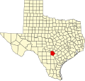
Leon Valley is a city in Bexar County, Texas, United States. It is an enclave on the northwestern side of San Antonio and is part of the San Antonio-New Braunfels metropolitan statistical area. Its population was 11,542 at the 2020 census. Leon Valley is an independent municipality surrounded by the city of San Antonio.
Leon Valley was developed in the 1940s as a farming community on Bandera Road between Helotes and San Antonio. In 1952, residents filed a petition for incorporation as an independent city, since the residents did not wish to be annexed by San Antonio. Leon Valley incorporated in 1954 under the leadership of its founding mayor, Raymond Rimkus. In 1960, it had a population of 536 and by 1970, its population grew to 1,960. In 1990, it had 9,581 people.
Leon Valley is located at 29°29′54″N98°36′45″W / 29.49833°N 98.61250°W (29.498280, −98.612594). [6] This is three miles southwest of the South Texas Medical Center, eight miles west of Uptown San Antonio and 10 miles northwest of downtown San Antonio.
According to the United States Census Bureau, the city has a total area of 3.4 square miles (8.8 km2), all land.
Climate data for Leon Valley, Texas | |||||||||||||
---|---|---|---|---|---|---|---|---|---|---|---|---|---|
Month | Jan | Feb | Mar | Apr | May | Jun | Jul | Aug | Sep | Oct | Nov | Dec | Year |
Record high °F (°C) | 90 (32) | 97 (36) | 97 (36) | 101 (38) | 102 (39) | 106 (41) | 105 (41) | 104 (40) | 113 (45) | 97 (36) | 91 (33) | 89 (32) | 113 (45) |
Mean daily maximum °F (°C) | 61 (16) | 66 (19) | 74 (23) | 80 (27) | 86 (30) | 91 (33) | 95 (35) | 95 (35) | 88 (31) | 82 (28) | 72 (22) | 63 (17) | 79 (26) |
Mean daily minimum °F (°C) | 39 (4) | 44 (7) | 51 (11) | 57 (14) | 63 (17) | 69 (21) | 72 (22) | 73 (23) | 68 (20) | 60 (16) | 50 (10) | 42 (6) | 57 (14) |
Record low °F (°C) | −1 (−18) | 5 (−15) | 20 (−7) | 32 (0) | 48 (9) | 48 (9) | 62 (17) | 46 (8) | 40 (4) | 29 (−2) | 24 (−4) | 6 (−14) | −1 (−18) |
Average precipitation inches (mm) | 1.48 (38) | 2.04 (52) | 1.92 (49) | 2.51 (64) | 3.31 (84) | 4.77 (121) | 1.53 (39) | 1.29 (33) | 2.54 (65) | 3.02 (77) | 1.84 (47) | 1.38 (35) | 27.63 (704) |
Average snowfall inches (cm) | 0.5 (1.3) | 0.5 (1.3) | trace | 0 (0) | 0 (0) | 0 (0) | 0 (0) | 0 (0) | 0 (0) | 0 (0) | 0 (0) | trace | 1 (2.5) |
Source: [7] |
Census | Pop. | Note | %± |
---|---|---|---|
1960 | 536 | — | |
1970 | 2,487 | 364.0% | |
1980 | 9,088 | 265.4% | |
1990 | 9,581 | 5.4% | |
2000 | 9,239 | −3.6% | |
2010 | 10,151 | 9.9% | |
2020 | 11,542 | 13.7% | |
U.S. Decennial Census [8] |
Race | Number | Percentage |
---|---|---|
White (NH) | 3,180 | 27.55% |
Black or African American (NH) | 572 | 4.96% |
Native American or Alaska Native (NH) | 26 | 0.23% |
Asian (NH) | 546 | 4.73% |
Pacific Islander (NH) | 9 | 0.08% |
Some other race (NH) | 61 | 0.53% |
Multiracial (NH) | 273 | 2.37% |
Hispanic or Latino | 6,875 | 59.57% |
Total | 11,542 |
As of the 2020 United States census, 11,542 people, 4,562 households, and 3,036 families were residing in the city.
At the 2010 census, 10,151 people, 4,158 households, and 2,636 families were living in the city. The racial makeup of the city was 80.98% White, 3.98% African American, 0.57% Native American, 3.71% Asian, 0.19% Pacific Islander, 8.06% from other races, and 2.51% from two or more races. Hispanic or Latino of any race were 56.22% of the population.
Of the 4,158 households, 24.22% had children under 18 living with them, 45.98% were married couples living together, 12.70% had a female householder with no husband present, and 36.60% were not families. About 29.89% of households were one person and 11.54% were one person 65 or older. The average household size was 2.44, and the average family size was 3.03.
The age distribution was 23.09% under 19, 6.82% from 19 to 24, 27.32% from 25 to 44, 25.85% from 45 to 64, and 16.92% were 65 or older. The median age was 39.4 years. For every 100 females, there were 92.66 males. For every 100 females 18 and over, there were 88.62 males.
At the 2000 census, 9,239 people, 3,576 households, and 2,521 families lived in the city. The population density was 2,708.0 inhabitants per square mile (1,045.6/km2). The 3,672 housing units hat an average density of 1,076.3 per square mile (415.6/km2). The racial makeup of the city was 78.07% White, 2.77% African American, 0.67% Native American, 1.95% Asian, 0.15% Pacific Islander, 13.19% from other races, and 3.19% from two or more races. Hispanics or Latinos of any race were 44.65%. [5]
Of the 3,576 households, 29.7% had children under 18 living with them, 56.0% were married couples living together, 11.0% had a female householder with no husband present, and 29.5% were not families; 24.8% of households were one person and 8.3% were one person 65 or older. The average household size was 2.56, and the average family size was 3.07.
The age distribution was 23.4% under the age of 18, 9.0% from 18 to 24, 28.1% from 25 to 44, 26.0% from 45 to 64, and 13.5% 65 or older. The median age was 38 years. For every 100 females, there were 94.9 males. For every 100 females age 18 and over, there were 90.3 males.
The median household income was $49,079 and the median family income was $56,543. Males had a median income of $32,917 versus $28,700 for females. The per capita income for the city was $21,743. About 4.8% of families and 8.1% of the population were below the poverty line, including 12.6% of those under age 18 and 6.6% of those age 65 or over. The median home price for Leon Valley has appreciated every year since 2000. In 2005 the median home price in Leon Valley was $95,480.
The United States Post Office operates the Leon Valley Post Office at 6825 Huebner Road. [12]
Leon Valley residents are zoned to schools in the Northside Independent School District. [13]
Leon Valley is served by these elementary schools: [14]
Leon Valley is served by these middle schools: [15]
Leon Valley is served by these high schools: [16]
Tamalpais-Homestead Valley is a census-designated place (CDP) in Marin County, California, United States. The population was 11,492 at the 2020 census.
Gardner is a city in Johnson County, Kansas, United States. As of the 2020 census, the population of the city was 23,287. It is located within the Kansas City metropolitan area.
Balcones Heights is a city in Bexar County, Texas, United States. Its population was 2,746 at the 2020 census, and it was incorporated in 1948. Balcones Heights is an enclave of San Antonio, surrounded entirely by the city, thus some residents and out-of-town visitors erroneously consider it merely a neighborhood of the larger city rather than its own unique community that did so to prevent annexation.
Castle Hills is an enclave city located in northern Bexar County, Texas, United States. As of the 2020 census, the city had a total population of 3,978. It is city surrounded by San Antonio.
Cross Mountain is a census-designated place (CDP) in Bexar County, Texas, United States. The population was 3,944 at the 2020 census, an increase over the figure of 3,124 tabulated in 2010. It is part of the San Antonio Metropolitan Statistical Area.
Grey Forest is a city in northwestern Bexar County, Texas, United States. The population was 492 at the 2020 census. It is part of the San Antonio Metropolitan Statistical Area.
Helotes is a city in Bexar County, Texas, United States, located on the far northwestern side of San Antonio. It is part of the San Antonio-New Braunfels metropolitan statistical area. Its population was 9,030 at the 2020 census.
Scenic Oaks is a census-designated place (CDP) in Bexar County, Texas, United States. It is part of the San Antonio Metropolitan Statistical Area. The population was 10,458 at the 2020 census, up from 4,957 at the 2010 census.
Shavano Park is a city located in Bexar County, Texas, United States. As of the 2020 census, the population was 3,524, an increase over the figure of 3,035 tabulated in 2010. It is part of the San Antonio Metropolitan Statistical Area, despite being much different in terms of demographics and having some of the wealthiest families in Bexar County.
Terrell Hills is a city in Bexar County, Texas, United States; it is located 5 miles (8 km) northeast of downtown San Antonio. As of the 2020 census Terrell Hills had a population of 5,045.
Windcrest is a city in Bexar County, Texas, United States. Its population was 5,865 at the 2020 census. It is part of the San Antonio metropolitan area.
Johnson City is a city and the county seat of Blanco County, Texas, United States. The population was 1,627 at the 2020 census. Founded in 1879 by James P. Johnson, it was named for early settler Sam E. Johnson, Sr. Johnson City is part of the Texas-German belt region.
Canyon Lake is a census-designated place (CDP) in Comal County, Texas, United States. The population was 31,124 at the 2020 census. It is part of the San Antonio Metropolitan Statistical Area.
Garden Ridge is a city in Comal County, Texas, United States, incorporated in 1972. The population was 4,186 at the 2020 census, up from 3,259 at the 2010 census. It is part of the San Antonio metropolitan statistical rea.
Alton is a city in Hidalgo County, Texas, United States. The population was 18,198 at the 2020 census.
Devine is a city in Medina County, Texas, United States. The population was 4,324 at the 2020 census. It is part of the San Antonio Metropolitan Statistical Area.
Natalia is a city in Medina County, Texas, United States. The population was 1,202 at the 2020 census. It was founded in 1912 and was named after Natalie Pearson Nicholson, daughter of Frederick Stark Pearson, engineer, designer and builder of the Medina Dam.
Fair Oaks Ranch is a city in Bexar, Comal, and Kendall counties in the U.S. state of Texas. The population was 9,833 at the 2020 census, and an estimated 10,505 in 2021. It is part of the San Antonio-New Braunfels Metropolitan Statistical Area. The city was named after Ralph Fair Sr, an oilman who had a large cattle ranch on the now residential town. The Fair family decided to sell a portion of the ranch to build what is now Fair Oaks Ranch in 1975.
San Diego is a city in Duval and Jim Wells counties, Texas, United States. The population was 3,748 at the 2020 census and 4,488 at the 2010 census. It is located primarily in Duval County, of which it is the county seat.
Alamo Heights is a city in Bexar County, Texas, United States, that is surrounded by the city of San Antonio. At the time of the 2020 census, the population of Alamo Heights was 7,357. It is part of the Greater San Antonio metropolitan area. A portion of the University of the Incarnate Word is in Alamo Heights.