Linganore-Bartonsville, Maryland

Last updated
Linganore-Bartonsville, Maryland
Frederick County Maryland Incorporated and Unincorporated areas Linganore-Bartonsville Highlighted.svg
Location of Linganore-Bartonsville, Maryland
Coordinates: 39°24′31″N77°19′26″W / 39.40861°N 77.32389°W / 39.40861; -77.32389
CountryFlag of the United States.svg  United States
State Flag of Maryland.svg  Maryland
County Flag of Frederick County, Maryland.svg Frederick
Area
  Total16.4 sq mi (42.5 km2)
  Land16.1 sq mi (41.7 km2)
  Water0.3 sq mi (0.8 km2)
Population
 (2000)
  Total12,529
  Density777.3/sq mi (300.1/km2)
Time zone UTC−5 (Eastern (EST))
  Summer (DST) UTC−4 (EDT)
FIPS code 24-47043

Linganore-Bartonsville was a census-designated place (CDP) in Frederick County, Maryland, United States, for the 2000 census, at which time its population was 12,529. For the 2010 census the area was split into three CDPs: Linganore, Bartonsville, and Spring Ridge.

Contents

Geography

Linganore-Bartonsville is located at 39°24′31″N77°19′26″W / 39.40861°N 77.32389°W / 39.40861; -77.32389 (39.408668, 77.323795). [1]

According to the United States Census Bureau, the CDP had a total area of 16.4 square miles (42 km2), of which, 16.1 square miles (42 km2) of it is land and 0.3 square miles (0.78 km2) of it (1.83%) is water.

Demographics

Historical population
CensusPop.Note
1990 4,079
2000 12,529207.2%
source: [2]

As of the census [3] of 2000, there were 12,529 people, 4,140 households, and 3,456 families residing in the CDP. The population density was 777.3 inhabitants per square mile (300.1/km2). There were 4,273 housing units at an average density of 265.1 per square mile (102.4/km2). The racial makeup of the CDP was 93.12% White, 3.28% African American, 0.21% Native American, 1.35% Asian, 0.05% Pacific Islander, 0.54% from other races, and 1.45% from two or more races. Hispanic or Latino of any race were 2.16% of the population.

There were 4,140 households, out of which 52.7% had children under the age of 18 living with them, 72.3% were married couples living together, 7.6% had a female householder with no husband present, and 16.5% were non-families. 12.3% of all households were made up of individuals, and 2.5% had someone living alone who was 65 years of age or older. The average household size was 3.03 and the average family size was 3.31.

In the CDP, the population was spread out, with 34.1% under the age of 18, 4.3% from 18 to 24, 39.2% from 25 to 44, 17.5% from 45 to 64, and 5.0% who were 65 years of age or older. The median age was 33 years. For every 100 females, there were 99.5 males. For every 100 females age 18 and over, there were 96.1 males.

The median income for a household in the CDP was $76,842, and the median income for a family was $80,523. Males had a median income of $56,037 versus $36,891 for females. The per capita income for the CDP was $29,390. About 1.8% of families and 2.5% of the population were below the poverty line, including 3.4% of those under age 18 and 3.3% of those age 65 or over.

Related Research Articles

<span class="mw-page-title-main">Claypool, Arizona</span> CDP in Gila County, Arizona

Claypool is a census-designated place (CDP) in Gila County, Arizona, United States. The population was 1,538 at the 2010 census, down from 1,794 at the 2000 census. It was named after W. D. Claypool, a member of both the State House of Representatives and State Senate in the 1910s and 1920s.

<span class="mw-page-title-main">South Gate, Maryland</span> Former census-designated place in Maryland, United States

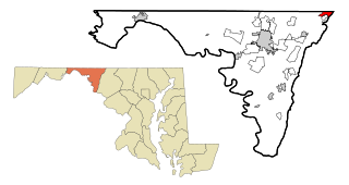
South Gate was a census-designated place (CDP) in Anne Arundel County, Maryland, United States, for the 2000 census, at which time its population was 28,672. It was added primarily to the Glen Burnie CDP for the 2010 census.

<span class="mw-page-title-main">Clover Hill, Maryland</span> Unincorporated community in Maryland

Clover Hill is an unincorporated community and former census-designated place (CDP) in Frederick County, Maryland, United States. The population was 3,260 at the 2000 census. The area was not listed as a CDP for the 2010 census, and no population total was published.

<span class="mw-page-title-main">Chewsville, Maryland</span> CDP in Maryland, United States

Chewsville is a census-designated place (CDP) in Washington County, Maryland, United States. The population was 293 at the 2000 census.

<span class="mw-page-title-main">Highfield-Cascade, Maryland</span> CDP in Maryland, United States

Highfield-Cascade is a census-designated place (CDP) in Washington County, Maryland, United States. The CDP encompasses two closely-spaced unincorporated communities, Highfield and Cascade, which are usually referred to separately. The population of the combined CDP was 1,141 at the 2000 census.

<span class="mw-page-title-main">Maugansville, Maryland</span> CDP in Maryland, United States

Maugansville is a census-designated place (CDP) in Washington County, Maryland, United States. The population was 2,295 at the 2000 census.

<span class="mw-page-title-main">Wilson-Conococheague, Maryland</span> CDP in Maryland, United States

Wilson-Conococheague is a census-designated place (CDP) in Washington County, Maryland, United States. The population was 2,262 at the 2020 census.

<span class="mw-page-title-main">Mehlville, Missouri</span> CDP in Missouri, United States

Mehlville is a census-designated place (CDP) in south St. Louis County, Missouri, United States, an area locally known as "South County". It is an inner-ring suburb of St. Louis, and part of the Greater St. Louis metropolitan area.

<span class="mw-page-title-main">Pine Ridge at Crestwood, New Jersey</span> Populated place in Ocean County, New Jersey, US

Pine Ridge at Crestwood is an unincorporated community and census-designated place (CDP) located within Manchester Township, in Ocean County, in the U.S. state of New Jersey. As of the 2010 United States Census, the CDP's population was 2,369.

<span class="mw-page-title-main">Mack North, Ohio</span> Former CDP in Ohio, United States

Mack North was a census-designated place (CDP) in Hamilton County, Ohio, United States. The population was 3,529 at the 2000 census. For the 2010 census, it became part of the Mack CDP.

Duchess Landing is a census-designated place (CDP) in McIntosh County, Oklahoma, United States. The population was 95 at the 2000 census.

<span class="mw-page-title-main">Labish Village, Oregon</span> Unincorporated community in the state of Oregon, United States

Labish Village is a census-designated place (CDP) in Marion County, Oregon, United States. The population was 454 at the 2020 census. It is part of the Salem Metropolitan Statistical Area.

<span class="mw-page-title-main">Lake Heritage, Pennsylvania</span> Census-designated place in Pennsylvania, United States

Lake Heritage is a census-designated place (CDP) in Adams County, Pennsylvania, United States. Its population was 2,158 at the 2020 census.

<span class="mw-page-title-main">Zion, Pennsylvania</span> Census-designated place in Pennsylvania, United States

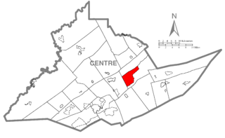
Zion is an unincorporated community and census-designated place (CDP) in Centre County, Pennsylvania, United States.

<span class="mw-page-title-main">Castanea, Pennsylvania</span> Census-designated place in Pennsylvania, United States

Castanea is a census-designated place (CDP) in Castanea Township, Clinton County, Pennsylvania, United States. The population was 1,125 at the 2010 census.

Guilford is a census-designated place (CDP) in Franklin County, Pennsylvania, United States. The population was 2,923 at the 2020 census.

Milroy is a census-designated place (CDP) that is located in the Kishacoquillas Valley of Mifflin County, Pennsylvania, United States. The population was 1,386 at the time of the 2000 census.

<span class="mw-page-title-main">Eagleville, Montgomery County, Pennsylvania</span> Census-designated place in Pennsylvania, United States

Eagleville is a census-designated place (CDP) in Montgomery County, Pennsylvania, United States. The population was 4,800 at the 2010 census. It is within Lower Providence Township.

<span class="mw-page-title-main">Valley View, York County, Pennsylvania</span> CDP in Pennsylvania, United States

Valley View is a census-designated place (CDP) in York County, Pennsylvania, United States. The population was 2,817 at the 2010 census.

<span class="mw-page-title-main">West Seneca (CDP), New York</span> Census-designated place in New York, United States

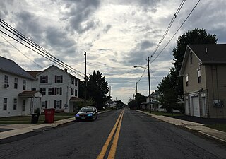
West Seneca is a hamlet and census-designated place (CDP) in Erie County, New York, United States. The population was 44,711 at the 2010 census. It is part of the Buffalo–Niagara Falls Metropolitan Statistical Area. The CDP corresponds exactly to the area of the town of West Seneca.

References

  1. "US Gazetteer files: 2010, 2000, and 1990". United States Census Bureau. 2011-02-12. Retrieved 2011-04-23.
  2. "CENSUS OF POPULATION AND HOUSING (1790-2000)". U.S. Census Bureau . Retrieved 2010-07-17.
  3. "U.S. Census website". United States Census Bureau . Retrieved 2008-01-31.