List of streets in Rome

Last updated

A view from ground level of the Via della Conciliazione. Note that the dome of the Basilica is not centred, as Piacentini chose instead to centre on the obelisk, which had been moved on the orders of Sixtus V. St peters vat distance.jpg
A view from ground level of the Via della Conciliazione. Note that the dome of the Basilica is not centred, as Piacentini chose instead to centre on the obelisk, which had been moved on the orders of Sixtus V.

This article covers some of the main streets in Rome, Italy.

Contents

Via Cavour, Rome

Via Cavour, Rome is a street in the Castro Pretorio rione of Rome, named after Camillo Cavour. It is served by the Rome Metro stations Cavour and Termini.

Via della Conciliazione

Via della Conciliazione (Conciliation Street [1] ) is a major street in the Rione of Borgo, leading to St. Peter's Basilica and the Vatican City. Around 500 m in length, [2] it connects Saint Peter's Square to the Castel Sant'Angelo on the western bank of the Tiber River. The road was constructed between 1937 and 1950, and it is the primary access route to the Square. In addition to shops and residences, it is bordered by a number of historical and religious buildings and palaces including the Palazzo Torlonia, the Palazzo dei Penitenzieri and the Palazzo dei Convertendi, and the church of Santa Maria in Traspontina.

Via del Corso

Via del Corso seen from Altare della Patria. Via del Corso.jpg
Via del Corso seen from Altare della Patria.

Via del Corso (the ancient via Lata), commonly known as the Corso, is the main street running through the historical centre of the city. It is remarkable for being absolutely straight in an area characterized by narrow meandering alleys and small piazzas. It is also wider than most streets in the centre of Rome, but still only has barely room for two lanes of traffic and two narrow sidewalks. The northern portion of the street is a pedestrian area. The length of the street is roughly 1.5 kilometres.

Via dei Fori Imperiali

Via dei Fori Imperiali, seen from the Colosseum looking northwest Via dei Fori Imperiali from the Colosseum, 2009.jpg
Via dei Fori Imperiali, seen from the Colosseum looking northwest

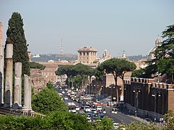
Via dei Fori Imperiali is a road in the centre of the city that runs in a straight line from the Piazza Venezia to the Colosseum.

The road, whose original name was "Via dell'Impero", was built during the dictatorship of Benito Mussolini. Its course takes it over parts of the Forum of Trajan, Forum of Augustus and Forum of Nerva, parts of which can be seen on both sides of the road. There has in recent years been a great deal of archeological excavation on both sides of the road, while significant Imperial Roman structures are still under it.

Via Giulia

Via Giulia is a street in the historic centre of Rome, mostly in rione Regola, although its northern part belongs to rione Ponte. It was one of the first important urban planning projects in Renaissance Rome.

Via Giulia was projected by Pope Julius II but the original plan was only partially carried out. This was the first attempt since antiquity to pierce a new thoroughfare through the heart of Rome and the first European example since antiquity of urban renewal. Via Giulia runs from the Ponte Sisto to the church of San Giovanni dei Fiorentini in a straight line, rather than following the tight curve of the Tiber. It became the most fashionable street for new construction for borghesi and for the Florentine community in the sixteenth century. Today its structures provide one of Rome's elite shopping streets, noted for its antique shops.

Via Margutta

Via Margutta is a small street in the centre of Rome, near to Piazza del Popolo, accessible as a small alley from Via del Babuino, in the old quarter of Campo Marzio, also known as "the foreigner's quarter", located near to the slopes of Mount Pincio. It is a place with many art galleries and fashionable restaurants, where before the Renaissance there were only modest craftsmen workshops and stables.

In the 1950s, after the film Roman Holiday it became an exclusive road, and a residence of many famous people, like film director Federico Fellini. It can be reached from the north traveling by the Via Cassia or by Flaminia until arriving to the large square Piazzale Flaminio, and then passing through the city door in the wall that leads to Piazza del Popolo square, from this point it is a walk of several meters to the left of the Flaminio Obelisk towards Via del Babuino; on the left side of this road there is an alley that leads to Via Margutta.

Via Nazionale

Via Nazionale is a busy street in Rome from Piazza della Repubblica leading towards the Piazza Venezia.

Already begun as the via Pia, named in honour of Pope Pius IX who had wanted to connect Stazione Termini to the city centre, the street was completed at the end of the 19th century through the ambition of several figures of the Risorgimento to create a "new Rome" as a capital of the unified Kingdom of Italy.[ citation needed ]

Via Sacra

The Via Sacra (Latin : Sacred Road) is the main street of ancient Rome, leading from the top of the Capitoline Hill, through some of the most important religious sites of the Forum (where it is the widest street), to the Colosseum.

Related Research Articles

Trevi (rione of Rome) Rione of Rome in Latium, Italy

Trevi is the 2nd rione of Rome, identified by the initials R. II, located in Municipio I. The origin of its name is not clear, but the most accepted theory is that it comes from the Latin trivium, because there were three streets all leading to the current Piazza dei Crociferi, a square next to the modern Trevi square. Its coat of arms is made of three swords on a red background.

Ponte (rione of Rome) Rione of Rome in Latium, Italy

Ponte is the 5th rione of Rome, identified by the initials R. V, and is located in Municipio I. Its name comes from Ponte Sant'Angelo, which connects Ponte with the rione of Borgo. This bridge was built by Emperor Hadrian in 134 AD to connect his mausoleum to the rest of the city. Though Pope Sixtus V changed the rione limits, so that the bridge belongs now to Borgo, not to Ponte anymore, the area has kept its name and a bridge as its coat of arms.

Parione Rione of Rome in Latium, Italy

Parione is the 6th rione of Rome, identified by the initials R. VI, and belongs to the Municipio I. Its name comes from the fact that in the area there was a huge ancient wall, maybe belonging to the stadium of Domitianus; the nickname people gave to this wall was Parietone, from which the name "Parione".

Regola Rione of Rome in Latium, Italy

Regola is the 7th rione of Rome, Italy, identified by the initials R. VII, and belongs to the Municipio I. The name comes from Arenula, which was the name of the soft sand that the river Tiber left after the floods, and that built strands on the left bank.

Prati Rione of Rome in Latium, Italy

Prati is the 22nd rione of Rome, identified by the initials R. XXII. It belongs to the Municipio I since 2013, while previously, along with Borgo and quartieri Trionfale and Della Vittoria, it was part of the Municipio XVII.

Campo Marzio Rione of Rome in Latium, Italy

Campo Marzio is the 4th rione of Rome, identified by the initials R. IV. It belongs to the Municipio I and covers a smaller section of the area of the ancient Campus Martius. The logo of this rione is a silver crescent on a blue background.

Piazza Venezia

Piazza Venezia is a central hub of Rome, Italy, in which several thoroughfares intersect, including the Via dei Fori Imperiali and the Via del Corso. It takes its name from the Palazzo Venezia, built by the Venetian Cardinal, Pietro Barbo alongside the church of Saint Mark, the patron saint of Venice. The Palazzo Venezia served as the embassy of the Republic of Venice in Rome.

Piazza del Popolo Urban square in Rome

Piazza del Popolo is a large urban square in Rome. The name in modern Italian literally means "People's Square", but historically it derives from the poplars after which the church of Santa Maria del Popolo, in the northeast corner of the piazza, takes its name.

Via Margutta

Via Margutta is a narrow street in the centre of Rome, near Piazza del Popolo, accessible from Via del Babuino in the ancient Campo Marzio neighborhood also known as "the foreigner's quarter". Mount Pincio is nearby. Via Margutta originally was home to modest craftsmen, workshops and stables, but now hosts many art galleries and fashionable restaurants.

Via del Corso

The Via del Corso is a main street in the historical centre of Rome. It is straight in an area otherwise characterized by narrow meandering alleys and small piazzas. Considered a wide street in ancient times, the Corso is approximately 10 metres wide, and it only has room for two lanes of traffic and two narrow sidewalks. The northern portion of the street is a pedestrian area. The length of the street is roughly 1.5 kilometres.

Via Giulia Thoroughfare in Rome, Italy

The Via Giulia is a street of historical and architectural importance in Rome, Italy, which runs along the left (east) bank of the Tiber from Piazza San Vincenzo Pallotti, near Ponte Sisto, to Piazza dell'Oro. It is about 1 kilometre long and connects the Regola and Ponte Rioni.

Flaminio – Piazza del Popolo (Rome Metro) Rome metro station

Flaminio–Piazza del Popolo is an underground station on Line A of the Rome Metro, inaugurated in 1980. The station is situated on the large Piazzale Flaminio, in the Flaminio quarter outside the Aurelian Walls, next to Piazza del Popolo, and is near the Campus Martius.

Via del Babuino

Via del Babuino is a street in the historic centre of Rome (Italy), located in the rione Campo Marzio. It connects Piazza del Popolo to Piazza di Spagna and is part of the complex of streets known as Tridente.

Tridente, Rome

The Tridente is the complex of roads formed by three straight streets of Rome (Italy), departing from Piazza del Popolo and diverging southward, taking the shape of a trident.

Via dei Coronari

Via dei Coronari is a street in the historic center of Rome. The road, flanked by buildings mostly erected in the 15th and the 16th century, belongs entirely to the rione Ponte and is one of the most picturesque roads of the old city, having maintained the character of an Italian Renaissance street.

Outline of Rome Overview of and topical guide to Rome

The following outline is provided as an overview of and topical guide to Rome:

Piazza Farnese

Piazza Farnese is the main square of the Regola district of Rome, Italy.

Flaminio (Rome) Quartiere of Rome in Latium, Italy

Flaminio is the 1st quartiere of the Italian capital Rome. Identified by the initials Q. I, it belongs to the Municipio II and has 13,018 inhabitants and an area of 1.1877 km². The name is derived from the Via Flaminia.

Pinciano Quartiere of Rome in Lazio, Italy

Pinciano is the 3rd quartiere of Rome (Italy), identified by the initials Q. III. The name derives from the Pincian Hill. It belongs to the Municipio II.

References

  1. The name finally settled upon for the project was chosen by journalist Franco Franchi after World War II; Delli, Sergio (1965). Le strade di Roma. Rome: Newton & Compton. p. sub vocem.
  2. Multimap reference ()