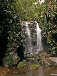
Mount O'Connell National Park Queensland | |
---|---|
IUCN category II (national park) | |
Nearest town or city | Marlborough |
Coordinates | 22°45′01″S150°02′22″E / 22.75028°S 150.03944°E Coordinates: 22°45′01″S150°02′22″E / 22.75028°S 150.03944°E |
Established | 1989 |
Area | 7.57 km2 (2.92 sq mi) |
Managing authorities | Queensland Parks and Wildlife Service |
See also | Protected areas of Queensland |
Mount O'Connell is a small national park in Queensland, Australia, 605 km northwest of Brisbane. The park is located in the Shoalwater drainage sub-basin within the Brigalow Belt bioregion. [1] It straddles the slopes of Mount O'Connell.
Queensland is the second-largest and third-most populous state in the Commonwealth of Australia. Situated in the north-east of the country, it is bordered by the Northern Territory, South Australia and New South Wales to the west, south-west and south respectively. To the east, Queensland is bordered by the Coral Sea and Pacific Ocean. To its north is the Torres Strait, with Papua New Guinea located less than 200 km across it from the mainland. The state is the world's sixth-largest sub-national entity, with an area of 1,852,642 square kilometres (715,309 sq mi).
Australia, officially the Commonwealth of Australia, is a sovereign country comprising the mainland of the Australian continent, the island of Tasmania and numerous smaller islands. It is the largest country in Oceania and the world's sixth-largest country by total area. The neighbouring countries are Papua New Guinea, Indonesia and East Timor to the north; the Solomon Islands and Vanuatu to the north-east; and New Zealand to the south-east. The population of 25 million is highly urbanised and heavily concentrated on the eastern seaboard. Australia's capital is Canberra, and its largest city is Sydney. The country's other major metropolitan areas are Melbourne, Brisbane, Perth and Adelaide.
Brisbane is the capital of and the most populated city in the Australian state of Queensland, and the third most populous city in Australia. Brisbane's metropolitan area has a population of 2 million, and the South East Queensland region, centred on Brisbane, encompasses a population of more than 3 million. The Brisbane central business district stands on the historic European settlement and is situated inside a peninsula of the Brisbane River, about 15 kilometres from its mouth at Moreton Bay. The metropolitan area extends in all directions along the floodplain of the Brisbane River Valley between Moreton Bay and the Great Dividing Range, sprawling across several of Australia's most populous local government areas (LGAs)—most centrally the City of Brisbane, which is by far the most populous LGA in the nation. The demonym of Brisbane is "Brisbanite" or "Brisbanian".
The Atalaya multiflora tree has been identified in the park. [2]
Atalaya multiflora, known as the broad leaved whitewood, is a rare and endangered rainforest tree of the soapberry family native to eastern Australia.
Cape Hillsborough is a national park in Mackay Region, Queensland, Australia.
Chesterton Range is a national park in South West Queensland, Australia, 585 km west of Brisbane. It is located north east of Morven in both the locality of Redford in the Maranoa Region and in Tyrconnel in the Shire of Murweh. It lies in the water catchment areas of three waterways. These are the Warrego River, Wallam Creek and the Maranoa River. The park protects part of Brigalow Belt South bioregion. To the north and to the west of the park is Orkadilla State Forest.
Chillagoe-Mungana Caves is a national park in Chillagoe, Shire of Mareeba, Queensland, Australia.
Littabella is a national park in Central Queensland, Australia, 336 km north of Brisbane.
The Main Range is a mountain range and national park in Queensland, Australia, located predominantly in Tregony, Southern Downs Region, 85 kilometres (53 mi) southwest of Brisbane. It is part of the World Heritage Site Gondwana Rainforests of Australia. It protects the western part of a semicircle of mountains in South East Queensland known as the Scenic Rim. This includes the largest area of rainforest in South East Queensland. The park is part of the Scenic Rim Important Bird Area, identified as such by BirdLife International because of its importance in the conservation of several species of threatened birds.
Minerva Hills is a national park in Central Queensland, Australia, 626 km northwest of Brisbane. The park features a rugged landscape with volcanic peaks, sheltered gorges, sheer cliffs, open woodlands and dry rainforest.
Moresby Range is a national park in Far North Queensland, Australia, 1,314 km northwest of Brisbane. It is part of the Coastal Wet Tropics Important Bird Area, identified as such by BirdLife International because of its importance for the conservation of lowland tropical rainforest birds.
Mount Chinghee is a national park in Queensland, Australia, 93 kilometres (58 mi) south of Brisbane. It is part of the Shield Volcano Group of the World Heritage Site Gondwana Rainforests of Australia inscribed in 1986 and added to the Australian National Heritage List in 2007. It is also part of the Scenic Rim Important Bird Area, identified as such by BirdLife International because of its importance in the conservation of several species of threatened birds.
Mount Pinbarren is a national park in Queensland, Australia, 129 km north of Brisbane. It is located in Pinbarren, a locality in the Shire of Noosa. Mount Pinbarren lies within the South East Queensland bioregion and the Mary River catchment area.
Nuga Nuga is a national park in Queensland, Australia, 515 km NW of Brisbane. It lies adjacent to Lake Nuga Nuga in the Comet River water catchment area of the Brigalow Belt bioregion.
Peak Range is a small national park in Central Queensland, Australia, 760 km northwest of Brisbane. It is located in the Brigalow Belt bioregion.
Rundle Range is a national park in Central Queensland, Australia, 471 km northwest of Brisbane. The park protects portions of the Calliope River and Fitzroy River drainage basins within the Brigalow Belt bioregion.
Snake Range is a national park in Central Queensland, Australia, 665 km northwest of Brisbane. The park lies within the Nogoa River drainage basin in the Brigalow Belt bioregion.
The Gondwana Rainforests of Australia, formerly known as the Central Eastern Rainforest Reserves, are the most extensive area of subtropical rainforest in the world. Collectively, the rainforests are a World Heritage Site with fifty separate reserves totalling 366,500 hectares from Newcastle to Brisbane.
The New South Wales Office of Environment and Heritage (OEH), a former division of the Government of New South Wales between April 2011 and July 2019, was responsible for the care and protection of the environment and heritage, which includes the natural environment, Aboriginal country, culture and heritage, and built heritage in New South Wales, Australia. Until its abolition in 2019, the OEH supported the community, business and government in protecting, strengthening and making the most of a healthy environment and economy within the state. The OEH was part of the Department of Planning and Environment cluster and managed national parks and reserves.
Humboldt is a national park in Queensland, Australia, approximately 110 km southeast of Emerald.
Annan River National Park is a national park on Cape York Peninsula in Far North Queensland, Australia. The Annan River from which the park gets its name, marks the northern and western extent of the park. To the east of the park is Walker Bay in the Coral Sea. The park was gazetted in 2006.
Malaan National Park is a national park in the Tablelands Region of Far North Queensland, Australia. There are two sections to the park. The largest section occupies the western third of Beatrice and the eastern fringe of Ravenshoe on the Atherton Tableland. The smaller section is in the north of Maalan. It belongs to the Wet Tropics of Queensland bioregion. The park was established to protect significant animal and plant communities. The areas were previously known as Dirran State Forest. It is adjacent to Tully Gorge National Park and Mount Fisher Forest Reserve.
Mount Binga National Park is a national park at Mount Binga in the Toowoomba Region of the Darling Downs region in southern Queensland, Australia. The park lies within the catchment area of Emu Creek, a tributary of the Brisbane River and belongs to the South East Queensland bioregion.
The O'Connell River is a river in North Queensland, Australia.
This Queensland protected areas related article is a stub. You can help Wikipedia by expanding it. |