
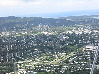
Gordonvale is a rural sugar-growing town and locality situated on the southern side of Cairns in the Cairns Region, Queensland, Australia. In the 2021 census, the locality of Gordonvale had a population of 6,944 people.

Atherton is a rural town and locality in the Tablelands Region, Queensland, Australia. In the 2021 census, the locality of Atherton had a population of 7,724 people.

Edmonton is a town and suburb in the Cairns Region, Queensland, Australia. In the 2021 census, the suburb of Edmonton had a population of 11,409 people.

Upper Mount Gravatt is a southern suburb in the City of Brisbane, Queensland, Australia. In the 2021 census, Upper Mount Gravatt had a population of 10,800 people.

Aloomba is a rural town and a locality in the Cairns Region, Queensland, Australia. In the 2021 census, the locality of Aloomba had a population of 576 people.

Mossman is a rural town and locality in the Shire of Douglas, Queensland, Australia. It is the administrative centre for the Douglas Shire Council In the 2021 census, the locality of Mossman had a population of 1,935 people.

East Russell is a coastal rural locality in the Cairns Region, Queensland, Australia. The town of Woolanmarroo South is in the north-east of the locality. In the 2021 census, East Russell had a population of 83 people.

Mirriwinni is a rural town and locality in the Cairns Region, Queensland, Australia. The spelling Miriwinni has also been used historically, but Mirriwinni is the official spelling from 8 October 2010. In the 2021 census, the locality of Mirriwinni had a population of 492 people.

Woopen Creek is a rural locality in the Cairns Region, Queensland, Australia. In the 2021 census, Woopen Creek had a population of 135 people.

Brinsmead is a suburb of Cairns in the Cairns Region, Far North Queensland, Australia. In the 2021 census, Brinsmead had a population of 5,537 people.

East Trinity is a coastal rural locality in the Cairns Region, Queensland, Australia. It was formerly known as Trinity East. In the 2021 census, East Trinity had a population of 238 people.

Fishery Falls is a locality in the Cairns Region, Queensland, Australia. In the 2021 census, Fishery Falls had a population of 205 people.
Manunda is a suburb of Cairns in the Cairns Region, Queensland, Australia. In the 2021 census, Manunda had a population of 5,191 people.

Miallo is a rural locality in the Shire of Douglas, Queensland, Australia. In the 2021 census, Miallo had a population of 406 people.

Little Mulgrave is a rural locality in the Cairns Region, Queensland, Australia. In the 2021 census, Little Mulgrave had a population of 269 people.

Wrights Creek is a rural locality in the Cairns Region, Queensland, Australia. In the 2021 census, Wrights Creek had a population of 160 people.

Barron is a suburb of Cairns in the Cairns Region, Queensland, Australia. In the 2021 census, Barron had a population of 68 people.

Goldsborough is a locality in the Cairns Region, Queensland, Australia. In the 2021 census, Goldsborough had a population of 1,099 people.
Packers Camp is a rural locality in the Cairns Region, Queensland, Australia. In the 2021 census, Packers Camp had a population of 136 people.

Green Hill is a rural locality in the Cairns Region, Queensland, Australia. In the 2021 census, Green Hill had a population of 177 people.


