Munneru

Last updated

Munneru is a left tributary of the Krishna River. [1] [2] It originates in Warangal District of Telangana, India and flows in the districts of Khammam District and Krishna District.

Telangana State in southern India

Telangana is a state in India situated on the centre-south stretch of the Indian peninsula on the high Deccan Plateau. It is the twelfth largest state and the twelfth-most populated state in India with a geographical area of 112,077 km2 (43,273 sq mi) and 35,193,978 residents as per 2011 census. On 2 June 2014, the area was separated from the northwestern part of Andhra Pradesh as the newly formed 29th state with Hyderabad as its historic permanent capital. Its other major cities include Warangal, Nizamabad, Khammam and Karimnagar. Telangana is bordered by the states of Maharashtra to the north, Chhattisgarh to the east, Karnataka to the west, and Andhra Pradesh to the east and south. The terrain of Telangana region consists mostly of hills, mountain ranges, and thick dense forests distribution of 27,292 sq. km. As of 2019, the state of Telangana is divided into 33 districts.

India Country in South Asia

India, also known as the Republic of India, is a country in South Asia. It is the seventh largest country by area and with more than 1.3 billion people, it is the second most populous country as well as the most populous democracy in the world. Bounded by the Indian Ocean on the south, the Arabian Sea on the southwest, and the Bay of Bengal on the southeast, it shares land borders with Pakistan to the west; China, Nepal, and Bhutan to the northeast; and Bangladesh and Myanmar to the east. In the Indian Ocean, India is in the vicinity of Sri Lanka and the Maldives, while its Andaman and Nicobar Islands share a maritime border with Thailand and Indonesia.

Contents

Sand dunes formed by Munneru River and old bridge keesara village of krishna district Sand dunes formed by Munneru River and old bridge keesara village of krishna district.jpg
Sand dunes formed by Munneru River and old bridge ̠ keesara village of krishna district

Origins

It originates near Mahabubabad town of Warangal District, Telangana. [3]

Mahabubabad Town in Telangana, India

Mahabubabad is a town and the district headquarters of Mahabubabad district in the Indian state of Telangana. It is on the west bank of the Munneru, which is one of the tributaries of the River Krishna. Mahabubabad is known for the Bayyaram Mines.

Flow

It flows through Dornakal Eru and comes via Kamanchkal to Danavaigudam suburb of Khammam city where it has a small Dam in order to facilitate water collection. Munneru acts as a water source to Khammam city. It goes through ManchiKanti Nagar, Kalavoddu, Moti Nagar, Prakash Nagar and Dhamsalampuram suburbs of Khammam city. It reaches Chinna Mandava and Lingala villages of Krishna District. It flows into Penuganchiprolu town, Keesara village [4] and finally discharges into the Krishna river at Eturu village near Nandigama downstream of Pulichintala dam. Muniyeru barrage was constructed in the year 1898 near Jaggayyapeta to supply irrigation water to 6,650 hectares land. [5]

Dornakal Census Town in Telangana, India

Dornakal is a census town in Mahabubabad district of Telangana, India. The town is important as a Railway Junction where a branch line emanates to Manuguru and Bhadrachalam Road and is also on the Vijayawada - Warangal - Secunderabad mainline it connects South India. Dornakal is the headquarters of the Diocese of Dornakal of the Church of South India, and is the second largest Diocese in Asia.

Khammam City in Telangana, India

Khammam, also known as Khammamett is the city in Khammam district of the Indian state of Telangana.It is the fourth largest city in the state.It is the headquarters of the Khammam district and Khammam mandal also. It is located about 193 kilometres (120 mi) east of the state capital, Hyderabad, 61 kilometres (38 mi) from Suryapet, 120 kilometres (75 mi) from Warangal and also it is located about 121 kilometres (75 mi) North of the Andhra Pradesh state capital, Amaravathi. The river Munneru flows on the western side of the city. As of 2011 census of India, Khammam urban agglomeration has a population of 2,62,255.However, on 19 October 2012, the civic body of Khammam was upgraded to Municipal corporation Post upgradation to corporation Khammam population is approximated to be 3,07,000.

Dam A barrier that stops or restricts the flow of surface or underground streams

A dam is a barrier that stops or restricts the flow of water or underground streams. Reservoirs created by dams not only suppress floods but also provide water for activities such as irrigation, human consumption, industrial use, aquaculture, and navigability. Hydropower is often used in conjunction with dams to generate electricity. A dam can also be used to collect water or for storage of water which can be evenly distributed between locations. Dams generally serve the primary purpose of retaining water, while other structures such as floodgates or levees are used to manage or prevent water flow into specific land regions. The earliest known dam is the Jawa Dam in Jordan, dating to 3,000 BC.

Bridges

Two Bridges across Munneru River in Khammam city. Munneru-bridge.jpg
Two Bridges across Munneru River in Khammam city.

There is a Water bridge constructed across Munneru to allow the flow of Nagarjunsagar water to Khammam city and other locations in Khammam district. Added to that Khammam has one old bridge for regular vehicles while heavy vehicles go through the new bridge.

Khammam district District of Telangana in India

Khammam District is a district in the eastern region of the Indian state of Telangana. The city of Khammam is the district headquarters. The district shares boundaries with Suryapet, Mahabubabad, Bhadhradhri districts and with Andhra pradesh state.


Construction has started on a newer bridge to connect Nelakondapalli and Kodad to Khammam via Prakashnagar. [6] This bridge would save the distance of travel and also would help easy flow of Munneru River.

Nelakondapalli Town in Telangana, India

Nelakondapally is a town and headquarters of a mandal in Khammam district, Telangana, India, located twenty-one kilometres from Khammam.

Kodad Town in Telangana, India

Kodad is a town in Suryapet district of the Indian state of Telangana. It is a municipality and the mandal headquarters of Kodad mandal in Kodad revenue division. It lies on the National Highway 65 between Hyderabad and Vijayawada.It is 44 km far away from the district headquarters Suryapet.

In the Krishna District there is a road and railway bridge at Lingala village. There is a road bridge at Penuganchiprolu while there is a bridge on National Highway 9 at Nandigama. ,

Penuganchiprolu Village in Andhra Pradesh, India

Penuganchiprolu is a village in Krishna district of the Indian state of Andhra Pradesh.

National Highway 9 (India) national highway in India

National Highway 9 is a National Highway in India in east-west direction. It starts at Malaut in Punjab and ends at Askot in Pithoragarh district in Uttarakhand. It passes through the states of Punjab, Haryana, Delhi, Uttar Pradesh and Uttarakhand. After renumbering of all national highways by National Highway Authority of India in 2010, the current NH 9 was formed by merging segments of five separate national highways in 2010; these were Old NH 10, Old NH 24, Old NH 87, Old NH 74 and Old NH 125.

Nandigama Town in Andhra Pradesh, India

Nandigama is a town in Krishna district of the Indian state of Andhra Pradesh. It is a Municipality and also the headquarters of Nandigama mandal in Vijayawada revenue division.

Flooding

Excess rainfall in Mahabubabad, Dornakal and other regions along with Khammam causes regular floods on Munneru river. [7] [8] 2013 has seen the over flow of Munneru river. [9] This led to a plan for building flood bank along the river bank. [10]

Related Research Articles

Washermanpet Suburb in Chennai, Tamil Nadu, India

Washermanpet, also known as Old Washermanpet, is a neighbourhood of Chennai, India. It is located north of Parrys Corner and adjacent to Royapuram. Washermanpet is famous for its jewelry shops and matchbox industries, many of which are centered on two main arterial roads.

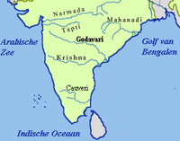
Dandavati (ದಂಡಾವತಿ) is a river that flows through Sorab, India. It originates from a reservoir in Kattinakere. The Kattinakere reservoir's overflow canal turns into a creek gathering strength on its way to become the river Dandavati. The river flows via Kuppe and joins the Varada river at a place called Bankasana near Anavatti. Varada, in turn, joins Tungabhadra and later Krishna River which finally joins the Bay of Bengal in the East coast of India. Sorab's Sri Ranganatha Temple is built on the bank of the Dandavati river.

Pranitha Vardhineni is an Indian Recurve Archer.

Kambalapally Chandra Shekar was an Indian cartoonist known for his political cartoons in English and in Telugu. He was born to a Telugu family in Suryapet, in the Nalgonda district of Andhra Pradesh. He completed his BSc degree in 1985 from Nagarjuna Government College in Nalgonda, followed by an MA in Telugu literature from Kakatiya University, Warangal.

Mangalampadu Village in Andhra Pradesh, India

Mangalam-padu is a village in Nellore district of the Indian state of Andhra Pradesh. It is located in Sullurpeta mandal.

Dummugudem Lift Irrigation Scheme

Dummugudem lift irrigation projects are lift irrigation schemes under execution which are located near Dummugudem, Khammam district in Telangana, India. There are three lift irrigation schemes by names Rajiv Dummugudem lift irrigation scheme, Indirasagar Rudrammakota Dummugudem lift irrigation scheme and Dummugudem to Sagar tail pond canal project. Rajiv Dummugudem lift irrigation scheme starting at 17°54′05″N80°52′45″E is planned to supply irrigation water for 200,000 acres in Khammam and Warangal districts drawing Godavari River water from the Dummugudem pond. Indira Dummugudem lift irrigation scheme starting at 17°33′49″N81°14′49″E is planned to supply irrigation water for 200,000 acres in Khammam, Krishna and West Godavari districts drawing Godavari River water from the back waters of Polavaram reservoir.

Koteswara Rao Indian educator

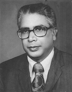
Koteswara Rao was a principal of the Regional Engineering College, Warangal which is now National Institute of Technology, Warangal

Tatipudi Reservoir reservoir in India

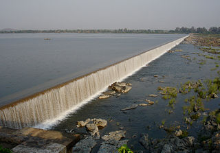
Tatipudi Reservoir is a water reservoir on River Gosthani located in Tatipudi, Vizianagaram in Andhra Pradesh. It is a water supply reservoir to the city of Visakhapatnam.

Jeedipalli reservoir is an irrigation project located in Anantapur district in Andhra Pradesh, India. It receives water from Handri-Neeva canal which draws water from Srisailam reservoir. It is located in Jeedipalli village of Beluguppa mandal.

Hasathpet cairns is a historic cairn circle or megalithic burial site located in Secunderabad. The site is among 12 other such sites that are state protected. There are also megalithic burial sites at Moulali, Kothaguda, Hyderabad Central University campus near Lingampalli. Later in 2008 a new site was also discovered at Kethepalli near Ramoji Film City.

Chaitanya Krishna is a South Indian actor who mainly stars in Telugu films. After finishing his engineering from S.R.K.R. Engineering College (Bhimavaram), he worked in a MNC as a software engineer. His love towards acting made him quit his job and then he participated in the first edition of Dhee Ultimate Dance Show. He soon secured his first lead role in Ninnu Kalisaka in 2009 and since then has acted in several Telugu films. He is well known for his roles in Sneha Geetham, Ala Modalaindi, Rowthiram, and Kalicharan. One of his short films, Peek-a-boo, directed by Srinu Pandranki, was selected to be featured in Cannes "Short Film Corner" 2014.

Khandubhai Kasanji Desai is the Governor of Andhra Pradesh between 11 April 1968 - 5 January 1975. He is a Gujarati.

Pannuru Sripathy

Pannuru Sripathi is a traditional painting artist who won Padma Shri Award in 2007. Born on 20 April 1943 in a small village near Tirupathi, Shri Sripathy obtained Diploma in Drawing from government of madras in 1969, Shri Sripathi has served the traditional craft by training more than 1000 younger generations and art lovers in India and abroad. Shripathi represented India in Japan, Russia, USA, Singapore, Austria, Germany, Europe, and Berlin for festival of India.

Sulaiman Khateeb was an Urdu, Deccani poet.

Jaggayyapeta mandal Mandal in Andhra Pradesh, India

Jaggayyapeta mandal is one of the 50 mandals in Krishna district of the state of Andhra Pradesh in India. It is under the administration of Vijayawada revenue division and the headquarters are located at Jaggayyapeta town. Krishna River flows through the mandal and is bounded by Penuganchiprolu, Nandigama, Chandarlapadu mandals of Krishna district, some part of Guntur district, Nalgonda and Khammam districts of Telangana.

Mahabubabad district District of Telangana in India

Mahabubabad is a district in the Indian state of Telangana. It was a part of the Warangal district prior to the re-organisation of districts in the state in October 2016.The district shares boundaries with Suryapet, Khammam, Bhadradri Kothagudem,Jayashankar Bhupalpalle,Warangal Rural, Jangaon districts.

Gandikota Reservoir

Gandikota Reservoir is an irrigation project located in Kadapa district of Andhra Pradesh in the Indian state. It receives water from Galeru Nagari Sujala Sravanthi Project canal. It is located in Kondapur village of Kondapur Mandal.

Rayadurg Junction railway station

Rayadurg Junction railway station is the primary railway station serving Rayadurg town in the Indian state of Andhra Pradesh. The station comes under the jurisdiction of Hubli railway division of South Western Railway zone. A new railway line connecting with Kalyandurg of Anantapur district was commissioned recently. It will be eventually extended to Tumkur.

Chulki Nala is a river in Bidar District. It starts at Chowkiwadi in Basavakalyan taluka. It flows for 42 km in Bidar district and joins the river Karanja. A Composite Dam is built near Mustapur village of Basava Kalyana Taluk in Bidar District for Irrigation and Drinking water purposes.The dam has a storage capacity of 0.93 tmcft of water. The catchment area is 243.55 km2. It provides drinking water to Basavakalyan town.

Irukkam is a lake island located in the middle of Pulicat Lake in the Nellore district of Andhra Pradesh. In recent times, Irukkam has emerged as a popular island resort owing to its proximity to Chennai.

References