This list includes properties and districts listed on the National Register of Historic Places in Alamance County, North Carolina. Click the "Map of all coordinates" link to the right to view an online map of all properties and districts with latitude and longitude coordinates in the table below.

This list includes properties and districts listed on the National Register of Historic Places in Orange County, North Carolina. Click the "Map of all coordinates" link to the right to view an online map of all properties and districts with latitude and longitude coordinates in the table below.

This list includes properties and districts listed on the National Register of Historic Places in Halifax County, North Carolina. Click the "Map of all coordinates" link to the right to view an online map of all properties and districts with latitude and longitude coordinates in the table below.

This list includes properties and districts listed on the National Register of Historic Places in Burke County, North Carolina. Click the "Map of all coordinates" link to the right to view an online map of all properties and districts with latitude and longitude coordinates in the table below.

This list includes properties and districts listed on the National Register of Historic Places in Franklin County, North Carolina. Click the "Map of all coordinates" link to the right to view an online map of all properties and districts with latitude and longitude coordinates in the table below.

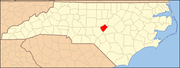
This list includes properties and districts listed on the National Register of Historic Places in Johnston County, North Carolina. Click the "Map of all coordinates" link to the right to view Google Maps of all properties and districts with latitude and longitude coordinates in the table below.

This list includes properties and districts listed on the National Register of Historic Places in Lincoln County, North Carolina. Click the "Map of all coordinates" link to the right to view an online map of all properties and districts with latitude and longitude coordinates in the table below.

This list includes properties and districts listed on the National Register of Historic Places in Moore County, North Carolina. Click the "Map of all coordinates" link to the right to view a Google map of all properties and districts with latitude and longitude coordinates in the table below.

This list includes properties and districts listed on the National Register of Historic Places in Cabarrus County, North Carolina. Click the "Map of all coordinates" link to the right to view an online map of all properties and districts with latitude and longitude coordinates in the table below.

This list includes properties and districts listed on the National Register of Historic Places in Warren County, North Carolina. Click the "Map of all coordinates" link to the right to view a Google map of all properties and districts with latitude and longitude coordinates in the table below.

This list includes properties and districts listed on the National Register of Historic Places in Bertie County, North Carolina. Click the "Map of all coordinates" link to the right to view an online map of all properties and districts with latitude and longitude coordinates in the table below.

This list includes properties and districts listed on the National Register of Historic Places in Cleveland County, North Carolina. Click the "Map of all coordinates" link to the right to view an online map of all properties and districts with latitude and longitude coordinates in the table below.

This list includes properties and districts listed on the National Register of Historic Places in Stokes County, North Carolina. Click the "Map of all coordinates" link to the right to view a Google map of all properties and districts with latitude and longitude coordinates in the table below.

This list includes properties and districts listed on the National Register of Historic Places in Onslow County, North Carolina. Click the "Map of all coordinates" link to the right to view a Google map of all properties and districts with latitude and longitude coordinates in the table below.

This list includes properties and districts listed on the National Register of Historic Places in Northampton County, North Carolina. Click the "Map of all coordinates" link to the right to view an online map of all properties and districts with latitude and longitude coordinates in the table below.

This list includes properties and districts listed on the National Register of Historic Places in Madison County, North Carolina. Click the "Map of all coordinates" link to the right to view an online map of all properties and districts with latitude and longitude coordinates in the table below.

This list includes properties and districts listed on the National Register of Historic Places in Harnett County, North Carolina, United States. Click the "Map of all coordinates" link to the right to view a Google map of all properties and districts with latitude and longitude coordinates in the table below.

This list includes properties and districts listed on the National Register of Historic Places in Pender County, North Carolina. Click the "Map of all coordinates" link to the right to view an online map of all properties and districts with latitude and longitude coordinates in the table below.
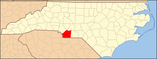
This list includes properties and districts listed on the National Register of Historic Places in Union County, North Carolina. Click the "Map of all coordinates" link to the right to view a Google map of all properties and districts with latitude and longitude coordinates in the table below.

This list includes properties and districts listed on the National Register of Historic Places in Person County, North Carolina. Click the "Map of all coordinates" link to the right to view a Google map of all properties and districts with latitude and longitude coordinates in the table below.