Parlier, California

Last updated

City of Parlier
Earl Ruth Park in Parlier.jpg
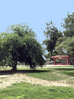
Earl Ruth Park
Seal of Parlier, California.png
Fresno County California Incorporated and Unincorporated areas Parlier Highlighted.svg
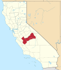
Location in Fresno County and the state of California
Usa edcp relief location map.png
Red pog.svg
City of Parlier
Location in the United States
Coordinates: 36°36′42″N119°31′37″W / 36.61167°N 119.52694°W / 36.61167; -119.52694 [1]
Country Flag of the United States (23px).png  United States
State Flag of California.svg  California
County Fresno
Incorporated November 15, 1921 [2]
Government
   State Senator Anna Caballero (D) [3]
   Assemblymember Joaquin Arambula (D) [4]
   U. S. Rep. Jim Costa (D) [5]
Area
[6]
  Total2.41 sq mi (6.24 km2)
  Land2.41 sq mi (6.24 km2)
  Water0.00 sq mi (0.00 km2)  0%
Elevation
[1]
344 ft (105 m)
Population
 (2020)
  Total18,494
  Density6,483.19/sq mi (2,503.53/km2)
Time zone UTC-8 (PST)
  Summer (DST) UTC-7 (PDT)
ZIP code
93648
Area code 559
FIPS code 06-55856
GNIS feature IDs 1659348, 2411376
Website www.parlier.ca.us

Parlier is a city in Fresno County, California, United States. As of the 2020 census, the city had a total population of 18,494, up from 14,494 in 2010. The city has one of the state's highest percentage of Latinos, a large majority of whom are seasonal migrant laborers who arrive and temporarily work in the area's agricultural sector. Parlier is located 5.5 miles (9 km) east-northeast of Selma, [7] at an elevation of 344 feet (105 m). [1]

Contents

Geography

According to the United States Census Bureau, the city has a total area of 2.2 square miles (5.7 km2), all land.

History and culture

In 1876, the I.N. Parlier family migrated from Springfield, Illinois to the present site of Parlier. The family's name, and city's namesake, was derived from DeParlier, their French ancestry. The Parlier family's general store, trading post and post office became the center of town. Small, family-run wheat farms were initially cultivated in the area. Wheat soon gave way to grapes, raisins and tree fruit, foods that Parlier continues to produce. Improved irrigation systems and arrival of the railroad helped Parlier establish itself as a hub among surrounding communities. [7]

Public schools

Parlier has four elementary schools, one junior high school, and one high school. In addition, there is a preschool and Head Start program, as well as continuing education.

Demographics

Historical population
CensusPop.Note
1930 564
1940 77637.6%
1950 1,41982.9%
1960 1,366−3.7%
1970 1,99345.9%
1980 2,90245.6%
1990 7,938173.5%
2000 11,14540.4%
2010 14,49430.0%
2020 18,49427.6%
U.S. Decennial Census [8]

2010

At the 2010 census Parlier had a population of 14,494. The population density was 6,606.9 inhabitants per square mile (2,550.9/km2). The racial makeup of Parlier was 7,251 (50.0%) White, 85 (0.6%) African American, 180 (1.2%) Native American, 77 (0.5%) Asian, 9 (0.1%) Pacific Islander, 6,387 (44.1%) from other races, and 505 (3.5%) from two or more races. Hispanic or Latino of any race were 14,137 persons (97.5%). [9]

The census reported that 14,492 people (100% of the population) lived in households, 2 (0%) lived in non-institutionalized group quarters, and no one was institutionalized.

There were 3,297 households, 2,276 (69.0%) had children under the age of 18 living in them, 1,950 (59.1%) were opposite-sex married couples living together, 662 (20.1%) had a female householder with no husband present, 339 (10.3%) had a male householder with no wife present. There were 288 (8.7%) unmarried opposite-sex partnerships, and 31 (0.9%) same-sex married couples or partnerships. 239 households (7.2%) were one person and 107 (3.2%) had someone living alone who was 65 or older. The average household size was 4.40. There were 2,951 families (89.5% of households); the average family size was 4.46.

The age distribution was 5,378 people (37.1%) under the age of 18, 1,841 people (12.7%) aged 18 to 24, 4,103 people (28.3%) aged 25 to 44, 2,375 people (16.4%) aged 45 to 64, and 797 people (5.5%) who were 65 or older. The median age was 25.1 years. For every 100 females, there were 104.9 males. For every 100 females age 18 and over, there were 106.3 males.

There were 3,494 housing units at an average density of 1,592.7 per square mile (614.9/km2), of which 3,297 were occupied, 1,524 (46.2%) by the owners and 1,773 (53.8%) by renters. The homeowner vacancy rate was 1.3%; the rental vacancy rate was 3.7%. 6,936 people (47.9% of the population) lived in owner-occupied housing units and 7,556 people (52.1%) lived in rental housing units.
2000

At the 2000 census, there were 11,145 people in 2,446 households, including 2,179 families, in the city. The population density was 6,862.9 inhabitants per square mile (2,649.8/km2). There were 2,644 housing units at an average density of 630.2 inhabitants/km2 (1,628.1 inhabitants/mi2). The racial makeup of the city was 33.63% White, 0.58% African American, 1.94% Native American, 0.82% Asian, 0.04% Pacific Islander, 59.43% from other races, and 3.56% from two or more races. 96.97% of the population were Hispanic or Latino of any race.

There were 2,446 households, 61.9% had children under the age of 18 living with them, 62.8% were married couples living together, 17.9% had a female householder with no husband present, and 10.9% were non-families. 6.8% of households were made up of individuals, and 3.7% had someone living alone who was 65 or older. The average household size was 4.51 and the average family size was 4.59.

The age distribution was 37.9% under the age of 18, 14.3% from 18 to 24, 29.7% from 25 to 44, 13.2% from 45 to 64, and 4.9% who were 65 or older. The median age was 24 years. For every 100 females, there were 108.6 males. For every 100 females age 18 and over, there were 112.5 males.

The median income for a household in the city was $24,539, and the median family income was $24,275. Males had a median income of $16,585 versus $17,589 for females. The per capita income for the city was $7,078. 36.0% of the population and 33.5% of families were below the poverty line. Out of the total people living in poverty, 42.9% were under the age of 18 and 18.6% were 65 or older.

Notable people

Sister cities

Related Research Articles

<span class="mw-page-title-main">Biggs, California</span> City in California, United States

Biggs is a city in Butte County, California, United States. The population was 1,707 at the 2010 census, down from 1,793 at the 2000 census. The 2018 population estimate is 1,724.

<span class="mw-page-title-main">Desert View Highlands, California</span> Census designated place in California, United States

Desert View Highlands is a census-designated place (CDP) in Los Angeles County, California, United States. The population was 2,360 at the 2010 census, up from 2,337 at the 2000 census. It is surrounded by the City of Palmdale.

<span class="mw-page-title-main">South San Gabriel, California</span> Census-designated place in California, United States

South San Gabriel is a census-designated place (CDP) in Los Angeles County, California, United States. The population was 8,070 at the 2010 census, up from 7,595 at the 2000 census.

<span class="mw-page-title-main">Boronda, California</span> Census-designated place in California, United States

Boronda is an unincorporated community and census-designated place (CDP) in Monterey County, California, United States. The population was 1,760 at the 2020 census. Boronda is located directly west of Salinas and is named after José Eusebio Boronda, a Californio ranchero, and located on the lands of his Rancho Rincón del Sanjón.

<span class="mw-page-title-main">La Palma, California</span> City in California, United States

La Palma is a city in Orange County, California, United States. The population was 15,568 at the 2010 Census, up from 15,408 at the 2000 census.

<span class="mw-page-title-main">North Tustin, California</span> Place in California, United States

North Tustin is an unincorporated community and census designated place (CDP) in Orange County, California. The population was 25,718 at the 2020 census, up from 24,917 in 2010. For statistical purposes, the United States Census Bureau has defined North Tustin as a census-designated place (CDP). It is both the largest CDP and largest unincorporated community in Orange County. The CDP's name was changed from Tustin Foothills in 2005. Located outside the city limits of Tustin, North Tustin has 92705 and 92780 ZIP Codes.

<span class="mw-page-title-main">El Cerrito, Riverside County, California</span> Census-designated place in Riverside County, California, United States

El Cerrito is a census-designated place (CDP) in Riverside County, California, United States. It is an unincorporated area mostly surrounded by the city of Corona. The population was 5,100 at the 2010 census, up from 4,590 at the 2000 census.

<span class="mw-page-title-main">Winchester, California</span> Census-designated place in California, United States

Winchester is a census-designated place (CDP) in Riverside County, California, USA. As of the 2010 census, the CDP had a total population of 2,534, up from 2,155 at the 2000 census.

<span class="mw-page-title-main">Hidden Meadows, California</span> Census designated place in California, United States

Hidden Meadows is a census-designated place (CDP) near Escondido in San Diego County, California. The population was 3,485 at the 2010 census, up from 3,463 at the 2000 census.

<span class="mw-page-title-main">East Foothills, San Jose</span> Census designated place in California, United States

East Foothills is a census-designated place (CDP) in Santa Clara County, California, United States and a neighborhood of San Jose. The population was 8,269 at the 2010 census and it is located about 4 miles east of downtown San Jose.

<span class="mw-page-title-main">Stanford, California</span> Census-designated place in Santa Clara County, California, US

Stanford is a census-designated place (CDP) in the northwest corner of Santa Clara County, California, United States. It is the home of Stanford University. The population was 21,150 at the 2020 census.

<span class="mw-page-title-main">Eldorado, Maryland</span> Town in Maryland, United States

EldoradoEL-də-RAY-doh is a town in Dorchester County, Maryland, United States. The population was 45 at the 2020 census, making it the second smallest town in Maryland.

<span class="mw-page-title-main">Salton Sea Beach, California</span> Census-designated place in California, United States

Salton Sea Beach is a census-designated place (CDP) in Imperial County, California, located 2.5 miles (4 km) southeast of Desert Shores. The population was 508 at the 2020 census, up from 422 at the 2010 census, up from 392 at the 2000 census. It is part of the El Centro, California Metropolitan Statistical Area. It was the location of the Naval Auxiliary Air Station Salton Sea.

<span class="mw-page-title-main">Clayton Township, Arenac County, Michigan</span> Civil township in Michigan, United States

Clayton Township is a civil township of Arenac County in the U.S. state of Michigan. The population was 1,001 at the 2020 census.

<span class="mw-page-title-main">Gladstone, Missouri</span> City in Missouri, United States

Gladstone is a city in Clay County, Missouri, United States and a suburb of Kansas City. The City of Gladstone is located about 10–20 minutes from downtown Kansas City, and about 10–20 minutes from Kansas City International Airport. As of the 2020 census, the city population was 27,063. It is part of the Kansas City metropolitan area.

<span class="mw-page-title-main">Lovington, New Mexico</span> City in New Mexico, United States

Lovington is a city in, and the county seat of, Lea County, New Mexico, United States. The population was 11,009 at the 2010 census, up from 9,471 in 2000.

<span class="mw-page-title-main">Golf Manor, Ohio</span> Village in Ohio, United States

Golf Manor is a village in Hamilton County, Ohio, United States. It is almost completely surrounded by the Pleasant Ridge and Roselawn neighborhoods of Cincinnati. The population was 3,814 at the 2020 census.

<span class="mw-page-title-main">Madeira, Ohio</span> City in Ohio, United States

Madeira is a city in Hamilton County, Ohio, United States. The population was 9,487 at the 2020 census. A residential suburb of Cincinnati, Madeira has a small downtown and some light industry.

<span class="mw-page-title-main">Hedgesville, West Virginia</span> Town in West Virginia, United States

Hedgesville is a town in Berkeley County, West Virginia, United States, in the state's Eastern Panhandle region. The population was 318 at the 2010 census. The town sits on WV 9, roughly 13 miles east of Berkeley Springs. In addition to its legal definition, Hedgesville has come to be the common name for the large and sparsely inhabited area of West Virginia's Eastern Panhandle bordered by the Potomac River to the North and East, a southern border defined roughly by an imaginary line from the city of Martinsburg to the tip of Virginia, and Berkeley Springs to the West.

<span class="mw-page-title-main">Oak Hill, West Virginia</span> City in West Virginia, United States

Oak Hill is a city in Fayette County, West Virginia, United States. The population was 8,179 at the 2020 census. It is part of the Beckley metropolitan area.

References

  1. 1 2 3 "Parlier". Geographic Names Information System . United States Geological Survey, United States Department of the Interior.
  2. "California Cities by Incorporation Date". California Association of Local Agency Formation Commissions. Archived from the original (Word) on November 3, 2014. Retrieved April 6, 2013.
  3. "Senators". State of California. Retrieved April 6, 2013.
  4. "Members Assembly". State of California. Retrieved April 6, 2013.
  5. "California's 21st Congressional District - Representatives & District Map". Civic Impulse, LLC. Retrieved April 6, 2013.
  6. "2019 U.S. Gazetteer Files". United States Census Bureau. Retrieved July 1, 2020.
  7. 1 2 Durham, David L. (1998). California's Geographic Names: A Gazetteer of Historic and Modern Names of the State. Clovis, Calif.: Word Dancer Press. p. 1086. ISBN   1-884995-14-4.
  8. "Census of Population and Housing". Census.gov. Retrieved June 4, 2015.
  9. "2010 Census Interactive Population Search: CA - Parlier city". U.S. Census Bureau. Archived from the original on July 15, 2014. Retrieved July 12, 2014.
  10. "Archived copy" (PDF). Archived from the original (PDF) on October 24, 2018. Retrieved May 20, 2020.{{cite web}}: CS1 maint: archived copy as title (link)