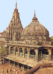
Gaya is of historical significance and is one of the major tourist attractions in the southern part of the state of Bihar. Gaya is 116 kilometres (72 mi) south of Patna, the capital city of Bihar. It is the state's second-largest city, with a population of 470,839, and is the headquarters of Gaya district and Magadh division. The city is surrounded on three sides by small, rocky hills, with the Phalgu River on its eastern side.

Sasaram sometimes also spelled as Sahasram, is a city in Bihar State of India. In ancient time it was a gateway of "Vihar" to visit Gaya, Rajgrih and Nalanda area and during prehistoric period Lord Buddha has passed through this way to be enlightened with verity & wisdom under Mahabodhi tree in Gaya.

Munger is a twin city and a Municipal Corporation situated in the Indian state of Bihar. It is the administrative headquarters of Munger district and Munger Division. It is the 11th largest city of Bihar by population.

Hajipur ( Hājīpur) is the largest city and headquarters of Vaishali district of Tirhut Division in the Indian state of Bihar. Hajipur is the 10th leading city and 17th most populous city of Bihar, making it the second-fastest developing city, next to Patna. It had a total population of 1.47 lakh as per census 2011. Vaishali district is ranked 8th on a list of 38 districts in Bihar in terms of growth.
Chhapra is a city and headquarters of the Saran district in the Indian state of Bihar. It is situated near the junction of the Ghaghara River and the Ganges River.

The East Central Railway is one of the 18 railway zones in India. It is headquartered at Hajipur and comprises Sonpur, Samastipur, Danapur, Mughalsarai, and Dhanbad divisions.

Arrah is a city and a municipal corporation in Bhojpur district in the Indian state of Bihar. The name is also sometimes transliterated as Ara. It is the district headquarters of Bhojpur district, located near the confluence of the Ganges and Sone rivers, some 24 miles from Danapur and 36 miles from Patna.
Aurangabad is a city in Aurangabad District, Bihar, India. It is the district's centre of governance and has a population of 102,244 as of 2011. The people of this region speak Magahi and Hindi.
Sonpur is a city and sub-division in the Indian state of Bihar, situated on the banks of the River Gandak and Ganges River in the Saran District. Sonpur once famous for its longest Railway Platform, it also hosts Asia's largest Cattle Fair which starts on Kartik Poornima.
Dighwara is a town and a Nagar Panchayat in the Saran district, state of Bihar, India. The name probably derives from 'Dirgh-dwar', literally "large gate", as Dighwara is claimed to be the entrance to the mythological city of king Daksha. During British Rule it was a Feudal Estate ruled by the Raghuvanshis.The town lies on the banks of Ganges River. A road bridge has been planned to be constructed over Ganges, between Dighwara and Danapur.
Masaurhi is a city and a Nagar Parishad in Patna district in the Indian state of Bihar. Masaurhi is also a Sub-division in Patna district.
Fatuha also spelled Fatwah or Fatwa, is a Satellite town in proposed Patna Metropolitan Region, in the Patna district in the Indian state of Bihar. Fatuha lies 24 km east of Patna the capital of Bihar. Fatuha is an important industrial centre known for small industries and its handloom industries. The city's name is said to come from its status as a center of textile manufacturing.

Patna is the capital and largest city of the state of Bihar in India. The city of Patna had an estimated city population of 1.68 million in 2011, making it the 19th largest city in India. With an area of 250 square kilometres (97 sq mi) and population over 2 million people, the Patna urban agglomeration is the 18th largest in India. Patna serves as the seat of Patna High Court. One of the oldest continuously inhabited places in the world, Patna was founded in 490 BCE by the king of Magadha. Ancient Patna, known as Patliputra, was the capital of the Magadh Empire under the Haryanka, Nanda, Mauryan, Shunga, Gupta and Pala empires. Pataliputra was a seat of learning and fine arts. It was home to many astronomers and scholars including Aryabhata, Vātsyāyana and Chanakya. During the Maurya period its population was about 400,000. Patna served as the seat of power, political and cultural centre of the Indian subcontinent during the Maurya and Gupta empires. With the fall of the Gupta Empire, Patna lost its glory. It was revived again in the 17th century by the British as a centre of international trade. Following the partition of Bengal presidency in 1912, Patna became the capital of Bihar and Orissa Province.

The Punpun River is a tributary of the Ganges. It originates in Palamu district of Jharkhand and flows through Chatra, Aurangabad, Gaya and Patna districts of the Indian states of Jharkhand and Bihar. Punpun is a place named after punpun river in Patna which is situated on the bank of punpun river. On the bank of punpun people cerlebrate Chath Puja.
Patna Regional Development Authority, abbreviated as PRDA, is a body of the Government of Bihar that is responsible for the infrastructure development of the Patna Metropolitan Region (PMR). It was established by the Bihar State Government with the sole purpose of the developing the infrastructure of the Patna Metropolitan Region. After Enactment of Bihar Municipal Act 2007, it is now merged into Patna Municipal Corporation.

Patna Metropolitan Region is an official definition of the metropolitan area surrounding the Bihar capital city Patna in India. It is also known as the Patna metropolitan area, or Patna planning area. It consists of one municipal corporation and five municipal councils of Patna district. The entire region has an estimated population of 3,874,000 over an area of 1,167.04 km². The Government of Bihar notified this area on 13 August 2014, replacing PRDA area, which included Hajipur in Vaishali district and Sonpur in Saran district.
The state of Bihar has a number of bridges, extending from few metres to a few kilometres. The history of long bridges goes back to the British Empire when the site for the Koilvar bridge( now called Abdul Bari) was surveyed in 1851. Since then a number of small and large bridges have crept up. Some are even largest of their kind. Gandhi Setu, joining Patna and Hajipur is Asia's second longest river bridge.

Gaighat is a neighbourhood of Patna in the eastern state of Bihar in India. It is located on the southern bank of river Ganges in Patna. The southern flank of Mahatma Gandhi Setu bridge connecting Patna and Hajipur rises from Gaighat in Patna. One end of Pontoon Bridge (Peepapul) connecting Patna and Hajipur over the river Ganges is also located in the area. Gaighat is part of the wider Alamganj area in Patna.
Murarchak is a village which comes under Chandos Gram Panchayat in Patna district in the Indian state of Bihar. It comes under Sigori Police Station and Paliganj Vidhan Sabha constituency and Pataliputra lok sabha constituency
Satyanarayan Singh was a Member of Bihar Legislative Assembly. He was elected from Chautham twice between 1990 to 2000 from Communist Party of India. He was state secretary of Bihar unit of Communist Party of India since 2015. He died on 2 August 2020 due to COVID 19 at AIIMS Patna.


