
Elko County is a county in the northeastern corner of the U.S. state of Nevada. As of the 2010 census, the population was 48,818. Its county seat is Elko. The county was established on March 5, 1869, from Lander County.

Elko is the largest city in and county seat of Elko County, Nevada, United States. The population was 18,297 at the 2010 census. The city straddles the Humboldt River.
The Shoshone or Shoshoni are a Native American tribe with four large cultural/linguistic divisions:

The Humboldt River is an extensive river drainage system located in north-central Nevada. It extends in a general east-to-west direction from its headwaters in the Jarbidge, Independence, and Ruby Mountains in Elko County, to its terminus in the Humboldt Sink, approximately 225 miles away in northwest Churchill County. Most estimates put the Humboldt River at 290 miles (470 km) long however, due to the extensive meandering nature of the river, its length is more closely estimated at 380 miles (612 km). It is located within the Great Basin Watershed and is the third longest river in the watershed behind the Bear River at 355 miles (570 km) and the Sevier River at 325 miles (523 km). The Humboldt River Basin is the largest sub-basin of the Great Basin encompassing an area of 16,840 square miles. It is the only major river system wholly contained within the state of Nevada.
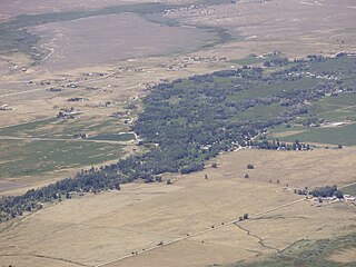
Lamoille is a rural census-designated place in Elko County in the northeastern section of the state of Nevada in the western United States. As of the 2010 census it had a population of 105. It is located 19 miles (31 km) southeast of Elko at the base of the Ruby Mountains at an elevation of 5,889 feet (1,795 m) and is part of the Elko Micropolitan Statistical Area.
An Indian colony is a Native American settlement associated with an urban area. Although some of them become official Indian reservations, they differ from most reservations in that they are placed where Native Americans could find employment in mainstream American economy. Many were originally formed without federal encouragement or sanction.

The North Fork of the Humboldt River is an approximately 70 miles (110 km) long tributary of the Humboldt River in northern Elko County, Nevada.

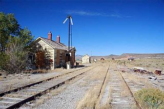
Deeth is an unincorporated community and census-designated places near the intersection of Interstate 80 and Nevada State Route 230 in Elko County, Nevada, United States.

State Route 230 is a state highway in the U.S. state of Nevada. It is a southern loop route off of Interstate 80 (I-80) between Elko and Wells, serving the communities of Deeth and Welcome and various ranches within Starr Valley. The road follows a "U" shaped path entirely within Elko County, and passes close to the East Humboldt Range. The road was constructed by the early 1960s and designated a state highway by the early 1990s.

State Route 232 is a state highway in Elko County, Nevada. It covers the majority of Clover Valley Road south of Wells.

Montello is a census-designated place (CDP) in Elko County, Nevada, United States. It is home to Montello Elementary School, which is part of the Elko County School District. The population of Montello was 84 as of the 2010 census. Two small bars and a market/motel selling fuel and sundries comprise the business district. Various cattle ranching operations surround the area.
Currie is an unincorporated community in Elko County, Nevada, United States. It is often considered a ghost town, and its population is around 20.

Donna's Ranch is a legal, licensed brothel located in Nevada, United States. Donna's Ranch is situated in Wells, in Elko County, on 8th Street. The ranch traces its history back to 1867 and is owned by Geoff Arnold. The boxer Jack Dempsey was a previous owner.

Ruby Valley is an unincorporated community in Ruby Valley, in Elko County, Nevada, United States.
Halleck is an unincorporated community in central Elko County, northeastern Nevada, in the Western United States.
Rowland is a ghost town in Elko County, Nevada in the United States.
Sherman is an unincorporated community semi ghost town in Elko County, Nevada in the United States.
Afton is a ghost town Elko County, Nevada, in the United States. Afton also was known as the name "Taber City".

Wilson Reservoir is a man-made lake in Elko County, Nevada in the United States. The reservoir was initially created in 1954 by the construction of Wilson Reservoir Dam. The Petan Ranch owns the reservoir, water rights, and a cabin, but public land surrounding the reservoir is administered by the Bureau of Land Management. The reservoir impounds the Wilson Creek for irrigation storage. It is located 83 miles north-northwest of Elko.
No. 1 Geisha was a legal brothel (ranch) and massage parlor in Elko, Nevada. The women who worked there were of Asian heritage. It was previously known as the Mona Lisa Ranch and CharDon's Club.


