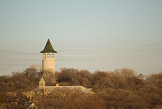
Prospect Park is a historic neighborhood within the University community of the U.S. city of Minneapolis, Minnesota. The area is bounded by the Mississippi River to the south, the City of Saint Paul, Minnesota to the east, the Burlington Northern railroad yard to the north, and the Stadium Village commercial district of the University of Minnesota to the west. The neighborhood is composed of several districts which include the East River Road area. The 1913 Prospect Park Water Tower is a landmark and neighborhood icon.

Shadyside is a neighborhood in the East End of Pittsburgh, Pennsylvania, United States. It has three zip codes and representation on Pittsburgh City Council by the council member for District 8. Shadyside is drawn from the name of a 19th-century Pennsylvania Railroad station in the area, which was named for its shady lanes.
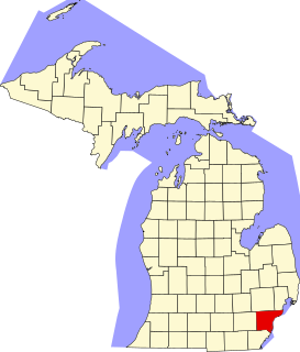
This is a list of the National Register of Historic Places listings in Wayne County, Michigan.
Columbus, the state capital and Ohio's largest city, has numerous neighborhoods within its city limits. Neighborhood names and boundaries are not officially defined. They may vary or change from time to time due to demographic and economic variables.

The Bemis Park Landmark Heritage District is located in North Omaha, Nebraska. Situated from Cuming Street to Hawthorne Avenue, Glenwood Avenue to 33rd Street, Bemis Park was annexed into Omaha in 1887, and developed from 1889-1922. The district was designated an Omaha Landmark in 1983.

The Gilbert Row, as of 2005 often referred to as Emery Row, is a group of historic rowhouses in the southern part of the Walnut Hills neighborhood of Cincinnati, Ohio, United States. Composed of six individual small houses and a more substantial structure designed as a commercial building, the row was built by the real estate firm of Thomas Emery's Sons according to a design by the Steinkamp Brothers architectural firm. Built in 1889, the complex became a model for many residential complexes constructed by Thomas Emery's Sons during the 1890s, including multiple apartment-style properties in Walnut Hills.
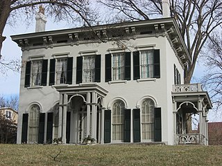
The Bernard H. Moormann House is a historic residence in eastern Cincinnati, Ohio, United States. Built in 1860 in the Italianate style, it is one of the most significant buildings in the neighborhood of East Walnut Hills.

The Archwood Avenue Historic District is a historic residential district in the Brooklyn Centre neighborhood of Cleveland, Ohio, United States. Composed of houses constructed around the turn of the twentieth century, it has been one of the neighborhood's most important streets since it was established, and it was designated a historic district in 1987.

The Academy Hill Historic District of Greensburg, Pennsylvania, is bounded approximately by Baughman Street, North Maple Avenue, Kenneth Street, Culbertson Avenue, Beacon Street, and North Main Street. It consists of 252 structures on 63.5 acres (0.257 km2), with the most notable buildings from the years 1880 to 1949. The earliest building, a former farmhouse at 333 Walnut Avenue, dates from 1840. The Academy Hill Historic District is directly to the north of the Greensburg Downtown Historic District.

The Montford Area Historic District is a mainly residential neighborhood in Asheville, North Carolina that is included in the National Register of Historic Places.

The Central Avenue Historic District is a small segment of the larger Grafton Hill neighborhood of Dayton, Ohio, United States. Composed of just two blocks near the border between Grafton Hill and Dayton View, the historic district comprises a cohesive collection of houses dating primarily from the turn of the 20th century, and it has been named a historic site.

The Drake Park Neighborhood Historic District is located adjacent to Drake Park near the historic downtown area in Bend, Oregon, United States. Because of the unique and varied architecture in the Drake Park neighborhood and its close association with the early development of the city of Bend, the area was listed on the National Register of Historic Places in 2005.

Winnona Park is a historic area in the southeast corner of the Atlanta, Georgia neighborhood of Decatur. It is listed as a historic district on the National Register of Historic Places, but it is not one of the City of Decatur's locally designated historic districts.

This is a list of the National Register of Historic Places listings in Summit County, Utah.
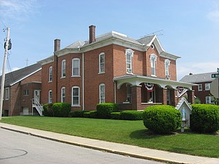
Immaculate Conception Catholic Church is a Roman Catholic parish in Botkins, Ohio, United States. Erected in 1865, the parish owns a complex of buildings constructed in a wide range of years, including two that have been designated as historic sites.

Oliver Johnson's Woods is a historic district and neighborhood on the northern side of Indianapolis, Indiana, United States. Located in southern Washington Township, the district occupies the site of what was once the family farm of Oliver Johnson. Born on the present site of the Indiana State Fairgrounds, Johnson grew up in a pioneer family that lived on the edge of the state capital city. Upon attaining adulthood, he bought property a short distance to the west, to which he moved in 1846. Here, he built a larger farmhouse in 1862, and he tilled the soil for most of the rest of his life. As Indianapolis grew northward, it reached the Johnson farm in the early twentieth century; the aged farmer and his sons saw the city's growth as an opportunity for financial gain, and in 1905 they announced the platting of 0.25 square miles (0.65 km2) of their property into individual lots. They chose an advantageous time to sell their property; as the new residents began to build their homes, an interurban railway was built along College Avenue on the district's western side that connected downtown with Broad Ripple. Many prosperous businessmen were attracted by the development's large lots and wooded streets; the city annexed Oliver Johnson's Woods in 1912, and by the outbreak of World War II, the streets were filled with large houses built in a wide variety of architectural styles. These early residents came from many different ethnicities: European immigrants were becoming more prosperous and leaving their ethnic enclaves, and new neighborhoods such as Oliver Johnson's Woods appealed to them. Among the neighborhood's leading residents was a colony of Jews of German descent.
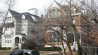
The Gilbert–Sinton Historic District is an area in the southern portion of the Walnut Hills neighborhood of Cincinnati, Ohio, United States. A triangle measuring slightly more than 13 acres (5.3 ha) in area, the district's edges are generally Morris Street and Sinton Avenue and the substantially larger Gilbert Avenue, which is concurrently designated as U.S. Route 22 and State Route 3.

The West Chapel Hill Historic District is a national historic district in Chapel Hill, North Carolina. The district comprises several small neighborhoods and is roughly bounded by West Cameron Avenue, Malette Street, Ransom Street, Pittsboro Street, University Drive and the Westwood Subdivision. The district was added to the National Register of Historic Places in 1998, and was enlarged in 2019. The district encompasses an upper-middle class residential neighborhood that developed during the nineteenth and twentieth centuries. The growth of the district is related to the development of the University of North Carolina at Chapel Hill and the town of Chapel Hill.

The Central Vinton Residential Historic District is a nationally recognized historic district located in Vinton, Iowa, United States. It was listed on the National Register of Historic Places in 2012. At the time of its nomination it contained 266 resources, which included 184 contributing buildings, one contributing structure, and 81 non-contributing buildings. Most of the contributing buildings are houses, and outbuildings. Second Avenue retains its brick paving and it is the contributing structure. Vinton is the county seat of Benton County, and this is one of its most affluent neighborhoods. Because the town is a center of commerce and government, it started to grow in the mid-to-late-nineteenth century.


