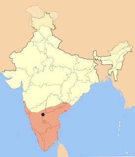
Sri City or Satyavedu Reserve Infracity Pvt. Ltd.[3] is an integrated business city (township) located on NH 16 in the state of Andhra Pradesh, India. Much of the Sri City area is in Chittoor District and a smaller area along the NH16[4] is in Nellore District of Andhra Pradesh, India.
National Highway 16 is a major National Highway in India, that runs along east coast of West Bengal, Odisha, Andhra Pradesh and Tamil Nadu. It was previously known as National Highway 5.
Andhra Pradesh is one of the 29 states of India. Situated in the south-east of the country, it is the seventh-largest state in India, covering an area of 162,970 km2 (62,920 sq mi). As per the 2011 census, it is the tenth-most populous state, with 49,386,799 inhabitants. The largest city in Andhra Pradesh is Visakhapatnam. Telugu, one of the classical languages of India, is the major and official language of Andhra Pradesh.
India, also known as the Republic of India, is a country in South Asia. It is the seventh-largest country by area, the second-most populous country, and the most populous democracy in the world. Bounded by the Indian Ocean on the south, the Arabian Sea on the southwest, and the Bay of Bengal on the southeast, it shares land borders with Pakistan to the west; China, Nepal, and Bhutan to the northeast; and Bangladesh and Myanmar to the east. In the Indian Ocean, India is in the vicinity of Sri Lanka and the Maldives; its Andaman and Nicobar Islands share a maritime border with Thailand and Indonesia.
Sri City is an Integrated Business City located along the NH-16 in the state of Andhra Pradesh. Being at proximity of 55 km north of Chennai, the facility has a seamless connectivity to road, air and sea ports all within 100 km radius. Sri City SEZ is characterized by its strong industrial base, productive workforce, and excellent industrial relations. It encompasses a multiproduct Special Economic Zone (SEZ) and a Free Trade and Warehousing Zone (FTWZ). Several Industrial Units belonging to diverse sectors like Automotive, Engineering, Electronics, Renewable Energy, Power, Paper, Toys, Furniture, Food Processing, Pharmaceutical, Textile, and allied industries have their presence in the SEZ.
Sri City SEZ started in 2007 by Dr Y.S Rajasekhar Reddy late Chief Minister of United Andhra Pradesh with an objective of radically transforming the economic landscape of the backward regions of Satyavedu and Varadiahpalem mandals in Andhra Pradesh. It became operational in 2009 and is now one of the most coveted business destinations in the country. At present the zone spans a total of 1088.581 Hectares, which includes a Processing Area of 609.780 Ha, Non-Processing Area of 478.801 Ha, and a Free Trade & Warehousing Zone of 24.12 Ha.
Satish Dhawan Space Centre (SDSC) or Sriharikota Range (SHAR) is a rocket launch centre operated by Indian Space Research Organisation (ISRO). It is located in Sriharikota in Andhra Pradesh. Sriharikota Range was renamed in 2002 after ISRO's former chairman Satish Dhawan.
Sriharikota is a barrier island off the Bay of Bengal coast located in the Nellore district of Andhra Pradesh, India. It houses the Satish Dhawan Space Centre, one of the two satellite launch centres in India. Indian Space Research Organisation (ISRO) launches satellites using multistage rockets such as the Polar Satellite Launch Vehicle and the Geosynchronous Satellite Launch Vehicle from Sriharikota.
Pulicat Lagoon is the second largest brackish water lagoon in India, after Chilika Lake. Pulicat Lagoon is considered to be the second largest brackish water body in India measuring 759* km2. The Lagoon is one of the three important wetlands to attract North-East Monsoon rain clouds during October to December season to Tamil Nadu. The lagoon comprises the following regions, which adds up 759 km2 according to Andhra Pradesh Forest Department*: 1) Pulicat Lake 2) Marshy/Wetland Land Region (AP) 3) Venadu Reserve Forest (AP) 4) Pernadu Reserve Forest (AP) The lagoon was cut across in the middle the Sriharikota Link Road, which divided the water body into lake and marshy land. The lake encompasses the Pulicat Lake Bird Sanctuary. The barrier island of Sriharikota separates the lake from the Bay of Bengal and is home to the Satish Dhawan Space Centre. Major part of the lake comes under Nellore district of Andhra pradesh.
Etymology
Symbol-Sri
The name Sri City is inspired by the title sri derived from Sanskrit. Sri is the sacred sound of cosmic auspiciousness and abundance in the Hindu religion. Written as sri, shree, sree or shri, it stands for abundance, auspiciousness, affluence, grace, wealth, light, luster, splendor, beauty, loveliness and authority.[7] The symbol has been used since Vedic times. Holiness is attached to the word when written or spoken. It is also added before a name to show respect. Sri is the beginning of the name of renowned temple towns in the region such as Srirangam, Srikalahasti, Sriperumbudur and Sriharikota. The world-famous temple city of Tirupati the abode of Lord Sri Venkateshwara (aka Srinivasa, Balaji) is also located near Sri City. After the symbol aum (ॐ) and the swastika, sri is the most popular symbol used in Hinduism. Sri is also the sacred of Lakshmi, the Hindu goddess of wealth and prosperity.
Sanskrit is a language of ancient India with a 3,500 year history. It is the primary liturgical language of Hinduism and the predominant language of most works of Hindu philosophy as well as some of the principal texts of Buddhism and Jainism. Sanskrit, in its variants and numerous dialects, was the lingua franca of ancient and medieval India. In the early 1st millennium CE, along with Buddhism and Hinduism, Sanskrit migrated to Southeast Asia, parts of East Asia and Central Asia, emerging as a language of high culture and of local ruling elites in these regions.
Wealth is the abundance of valuable financial assets or physical possessions which can be converted into a form that can be used for transactions. This includes the core meaning as held in the originating old English word weal, which is from an Indo-European word stem. The modern concept of wealth is of significance in all areas of economics, and clearly so for growth economics and development economics, yet the meaning of wealth is context-dependent. An individual possessing a substantial net worth is known as wealthy. Net worth is defined as the current value of one's assets less liabilities.
Divine grace is a theological term present in many religions. It has been defined as the divine influence which operates in humans to regenerate and sanctify, to inspire virtuous impulses, and to impart strength to endure trial and resist temptation; and as an individual virtue or excellence of divine origin.
The district has hundreds of monuments, memorial rocks and memorials. The historical memorials date back to over 1000 years.
The history of the district, which was carved out in 1905 from then Cuddapah, Nellore and North Arcot districts, has been shaped by the ups and downs of several Dravidian kingdoms. It was a British military post until 1884. Back to 1000 years when the region was dominated by Vijayanagara Empire[8] and is linked with the Aravidu dynasty.[9]
Nellore is a city and district headquarters of Nellore district in the Indian state of Andhra Pradesh. It is located on the banks of Penna River and is the fourth most populous city in the state.
North Arcot was a former district in Madras State, which was established by the British in the 19th century had Chittoor as its headquarters. On 1 April 1911, district was split into Chittoor district and North Arcot District.
The Vijayanagara Empire was based in the Deccan Plateau region in South India. It was established in 1336 by Harihara I and his brother Bukka Raya I of Sangama Dynasty. The empire rose to prominence as a culmination of attempts by the southern powers to ward off Islamic invasions by the end of the 13th century. It lasted until 1646, although its power declined after a major military defeat in the Battle of Talikota in 1565 by the combined armies of the Deccan sultanates. The empire is named after its capital city of Vijayanagara, whose ruins surround present day Hampi, now a World Heritage Site in Karnataka, India. The writings of medieval European travelers such as Domingo Paes, Fernão Nunes, and Niccolò Da Conti, and the literature in local languages provide crucial information about its history. Archaeological excavations at Vijayanagara have revealed the empire's power and wealth.
Geography
It is situated between north latitudes of 13°29’50" & 13°34’40" and east longitudes of 79°57’30" & 80°02’50",[10] at an average elevation of about 20 metres above MSL (66ft) covering parts of Chittoor district and Nellore district of Andhra Pradesh. It is alongside NH 5 which forms part of the Golden Quadrilateral.[6] A creek (Karipeti Kalava) flows through Sri City passing through a number of lakes on the way to joining Pulicat Lake north of Tada. There is a state forest on the western boundary. The Telugu Ganga project carrying Krishna River water to Chennai passes along the western boundary of Sri City.
National Highway 5 commonly referred to as NH5, is a national highway in India running from West to East, connecting Firozpur in Punjab to the Sino-Indian border at Shipki La. The highway passes through Moga, Jagraon, Ludhiana, Kharar, Chandigarh, Kalka, Solan, Shimla, Theog, Narkanda and continues along the Sutlej River till its origin near the border.
The Golden Quadrilateral (GQ) is a national highway network connecting most of the major industrial, agricultural and cultural centres of India. It forms a quadrilateral connecting the four major metro cities of India, viz., Delhi (north), Kolkata (east), Mumbai (west) and Chennai (south). Other cities connected by this network include Ahmedabad, Bengaluru, Balasore, Bhubaneswar, Cuttack, Durgapur, Jaipur, Kanpur, Pune, Surat, Vijayawada, Ajmer, Vizag, Bodhgaya, Varanasi, Agra, Mathura, Dhanbad, Gandhinagar, Udaipur, and Vadodara.
Tada is a village in Nellore district of Andhra Pradesh.
Soils
The soils of the area can be broadly classified as:
The transition located at the contact of laterite and alluvium is podozolic–latosolic soil
Latosol is a name given to soils found under tropical rainforests with a relatively high content of iron and aluminium oxides. They are typically classified as oxisols or ferralsols. It is largely correct to say that latosols are tropical soils, but the reverse is not true because there are many soils in the tropics that are not latosolic. Latosols are red or yellowish-red in colour throughout and they do not have distinct horizons like a podsol. The red colour comes from the iron oxides in the soil. They are deep soils, often 20-30m deep whereas podsols are 1-2m deep.
Laterite is a soil and rock type rich in iron and aluminium and is commonly considered to have formed in hot and wet tropical areas. Nearly all laterites are of rusty-red coloration, because of high iron oxide content. They develop by intensive and prolonged weathering of the underlying parent rock. Tropical weathering (laterization) is a prolonged process of chemical weathering which produces a wide variety in the thickness, grade, chemistry and ore mineralogy of the resulting soils. The majority of the land area containing laterites is between the tropics of Cancer and Capricorn.
In soil science, Podzols are the typical soils of coniferous or boreal forests. They are also the typical soils of eucalypt forests and heathlands in southern Australia. In Western Europe, Podzols develop on heathland, which is often a construct of human interference through grazing and burning. In some British moorlands with Podzolic soils, Cambisols are preserved under Bronze Age barrows.
Climate
Satyavedu Mandal rainfall (mm)
The area experiences both the southwest monsoon and the northeast monsoon. In between there are lull periods. The average rainfall per annum as recorded in Satyavedu is 1305mm.
mid-May to mid-August – southwest monsoon
mid-August to mid-October – transition / calm period
mid-October to mid-January – northeast monsoon
mid-January to mid-May – transition / calm period
Flora
Trees – Red sanders wood is the speciality of this area. It is the heartwood of Pterocarpus santalinus, a small tree indigenous to Southern India[11] and the Philippines. During the Middle Ages it was classed as a spice and used for culinary purposes, and at one time it was supposed to possess medicinal properties. It is also called raktachandan. The literal meaning of raktachandan is blood coloured sandalwood. This kind of wood has a special and rust red colour and it is used to carve a number of products including panels, framework and traditional dolls.
Sricity Nature Society[12] works towards preservation of natural biodiversity and conservation of flora and fauna in and around Sri City through various intervention programs and awareness activities with the help of the student and resident communities in and around Sri City.
Languages
Telugu is the official and spoken language.[13] Most of the educated populace speak English and are bi-lingual.[14]
Demographics
Sri City forms part of Satyavedu and Varadaiahpalem mandals of Chittoor District. It is part of the Satyavedu constituency and Tirupati MP constituency. As per 2011 census the total population of the satyavedu constituency is 2,77,010,[15] with a literacy rate of 78.98, well over national rate of Literacy in India which stand at 74.04%.[16]
The Industrial Zone includes a Special Economic Zone (SEZ) for Export Oriented Industry and Domestic Tariff Zone (DTZ) for Domestic Industry. It is a business destination for global companies to establish Manufacturing, Services and Trading operations in India.[19]
The district boasts few of the finest ancient/modern temples of the country. The archaeological treasures unearthed from the town and its adjoining areas occupy the pride of place at different museums. The Chandragiri Fort is known for its architectural marvels including the Srikalahasti temple.
Chittoor is a city and district headquarters in Chittoor district of the Indian state of Andhra Pradesh. It is also the mandal and divisional headquarters of Chittoor mandal and Chittoor revenue division, respectively. The city has a population of 2,89,625 and that of the agglomeration is 3,53,766.
Rayalaseema is a geographic region in the Indian state of Andhra Pradesh. It comprises four southern districts of the state namely, Anantapur, Chittoor, Kadapa and Kurnool. As of 2011 census of India, the region with four districts had a population of 15,184,908 and covers an area of 67,526 km2 (26,072 sq mi).
Sullurupeta is a town in Nellore district of Andhra Pradesh, India. It is a municipality and also the mandal headquarters of Sullurpeta mandal. It serves as a gateway to Satish Dhawan Space Centre at Sriharikota. Sullurupeta is famous for Chengallamma Temple probably built in 10th century.
Tirupati is a city in Chittoor district of the Indian state of Andhra Pradesh. It is a municipal corporation and the headquarters of Tirupati (urban) mandal, and of the Tirupati revenue division. As of 2011 census, it had a population of 374,260, making it the ninth most populous city in Andhra Pradesh. It is the seventh most urban agglomerated city in the state, with a population of 459,985. Tirupati is considered one of the holiest Hindu pilgrimage sites because of Tirumala Venkateswara Temple, besides other historical temples, and is referred to as the "Spiritual Capital of Andhra Pradesh". Tirupati is also home to many educational institutions and universities. For the year 2012–13, India's Ministry of Tourism named Tirupati as the "Best Heritage City". Tirupati has been selected as one of the hundred Indian cities to be developed as a smart city under Smart Cities Mission by Government of India.
Chittoor district, is a district in Rayalaseema region of the Indian state of Andhra Pradesh. The district headquarters is located at Chittoor. It has a population of 4,170,468 according to 2011 census of India. Chittoor district has many major temples including Tirupati, Srikalahasti and Kanipakam and other temples. It lies in the Poini river valley of southernmost Andhra Pradesh along the Chennai – Bangalore section of Chennai-Mumbai highway. It is a major market centre for mangoes, grains, sugarcane, and peanuts.Sricity integrated business city lies in Satyavedu mandal acts as a major industrial hub for chittoor district as well as Andhra Pradesh as a whole.
Srikalahasti is a holy town in Chittoor district of the Indian state of Andhra Pradesh. It is a municipality and the mandal headquarters of Srikalahasti mandal in Tirupati revenue division. The town is a part of Tirupati Urban Development Authority, which is located on the banks of the River Swarnamukhi. The Srikalahasti Temple is one of the important ancient Shiva temples of Southern India.
Arambakkam is a village in the Tiruvallur district of Tamil Nadu, India. It is located in the Gummidipoondi taluk. Fishing is the main occupation here, within a short distance lies Bheemavarai Palyam where a creek locally called Uppankali juts out from the Pulicat-Arambakkam lagoon. It has a railway station.
Sarvepalli Assembly constituency is a constituency of the Andhra Pradesh Legislative Assembly, India. It is one of 10 constituencies in the Nellore district.
Gudur Assembly constituency is a SC reserved constituency of the Andhra Pradesh Legislative Assembly, India. It is one among 10 constituencies in the Nellore district.
Sullurupeta Assembly constituency is a SC reserved constituency of the Andhra Pradesh Legislative Assembly, India. It is one among 10 constituencies in the Nellore district.
Venkatagiri Assembly constituency is a constituency of the Andhra Pradesh Legislative Assembly, India. It is one among 10 constituencies in the Nellore district.
Tirupati Assembly constituency is a constituency of Andhra Pradesh Legislative Assembly, India. It is one of 14 constituencies in Chittoor district.
Srikalahasti Assembly constituency is a constituency of Andhra Pradesh Legislative Assembly, India. It is one among 14 constituencies in Chittoor district.
Satyavedu Assembly constituency is constituency of Andhra Pradesh Legislative Assembly, India. It is one among 14 constituencies in the Chittoor district.
Indian Institute of Information Technology, Sri City is an educational institute of national importance located in Sri City, Chittoor District Andhra Pradesh, India. It is one of the new IIITs being set up by the Ministry of Human Resource Development, Government of India, under the Public Private Partnership with AP government and Sri City consortium. The IIIT campus at Sri City is spread over 90 acres.
Nellore is a city in the Nellore district of the Indian state of Andhra Pradesh. It is located on the banks of the Penna River in Nellore mandal of Nellore revenue division. The city is the fourth most populous settlement of the state well known for its agriculture and aquaculture.The Andhra Pradesh Tourism Development Corporation is the state tourism department, responsible for maintaining, promoting and developing the tourism sector. Nellore is famous for scenic beaches, historic forts, temples, darghas, bird and wildlife sanctuaries.
↑ Tirupati MP also pointed out that Sri City was in close proximity to NH16 & 2 International Airports – Chennai and Tirupati.
↑ Satish Dhawan Space Centre (SHAR) located on the eastern side of the Pulicate Lake separating Sricity and the Satellite Launching Station – Source – Google Maps
1 2 3 "Archived copy". Archived from the original on 30 March 2012. Retrieved 5 October 2011.CS1 maint: Archived copy as title (link) Places to visit near sriharikota (shar) | About Sriharikota-Source-Website on Sriharikota Range (SHAR)
1 2 Special Economic Zones in India: Recent Developments and Future Prospects, Sri City distance from Chennai, Ennore and Krishnapattnam Ports, refer Page 8-Source-Indian Institute of South Asian Studies, National University of Singapore
↑ Images of Changalamma Temple at Sullurpeta on Nellore District Website-Source Govetment of India
This page is based on this Wikipedia article Text is available under the CC BY-SA 4.0 license; additional terms may apply. Images, videos and audio are available under their respective licenses.