
Poonch or Punch is a district of the Jammu division of Indian-administered Jammu and Kashmir in the disputed Kashmir region. With headquarters in the town of Poonch, it is bounded by the Line of Control on three sides. The 1947–48 war between India and Pakistan divided the earlier district into two parts. One went to Pakistan and the other became part of the then-Indian state of Jammu and Kashmir.
Nowshera is a town and the headquarters of an eponymous tehsil of Rajouri district in the Jammu division of the Indian Union Territory of Jammu and Kashmir. It is governed by a Municipal committee and in rural area of Nowshera consists of 14 panchayats governed by local bodies under the supervision of district administration Rajouri.

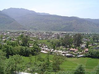
Rajouri or Rajauri is a city in the Rajouri district in the Jammu division of the Indian union territory of Jammu and Kashmir. It is located about 155 kilometres (96 mi) from Srinagar and 150 km (93 mi) from Jammu city on the Poonch Highway.

Poonch, is a town and the administrative headquarters of the Poonch district, of the Indian-administered union territory of Jammu and Kashmir, which is part of the larger disputed territory of Kashmir. It is located near the Line of Control – the de facto border in the disputed region. Poonch shares a de facto border with the Poonch district of the Pakistan-administered, self-governing territory of Azad Kashmir.
Topa is a village in Mendhar Tehsil, Poonch district in the Indian union territory of Jammu and Kashmir. During the Indo-Pakistani War of 1965, the Battle of Topa was fought here by 5 Gorkha Rifles.
The Haveli Tehsil is a tehsil of the Poonch district in the Indian union territory of Jammu and Kashmir. It is headquartered at the Poonch Town.
Surankote is a town in the Surankote Tehsil of the Poonch district of the Indian union territory of Jammu and Kashmir. It occupies the Surankote valley, located between the Pir Panjal and ranges within the Himalayas. It receives snowfall in winters. It is famous for the existence of lakes on the Pir Panjal range which are not still connected with the outside world. Although some people visit these lakes by foot for recreation and refreshment.

Rathsun or Rathsoon is a village and block located in the Jammu and Kashmir's Budgam district. It is situated at the base of the Pir Panjal Range of the Himalayas. It falls under the administrative division of tehsil Beerwah one of the nine tehsils of district Budgam. It is about 23.7 kilometres (14.7 mi) via Beerwah-Budgam Road from district headquarters Budgam, 7 km (4.3 mi) from Beerwah, Jammu and Kashmir, it is situated 29 km (18 mi) away from Srinagar, the summer capital of Jammu and Kashmir. Magam, is nearest town to Rathsun .The shrine of Sufi saint Baba Hanifudin Reshi is on a hill of this village.
Chitterkote is a small village in tehsil Karnah in Kupwara district in the Indian union territory of Jammu and Kashmir. The village is located 75 kilometres (47 mi) from district headquarters Kupwara and 8 kilometres (5.0 mi) from tehsil headquarters Tangdhar.
Bhimber Gali is a village in the Poonch district of Jammu and Kashmir, India. It is often called BG locally as an abbreviated form of Bhimber Gali. It is named after a mountain pass "Bhimber Gali" on the mountain ridge separating the Poonch River and the Rajouri Tawi basins. Bhimber Gali is the point at which four roads meet, one from Hamirpur Balakote, second from Rajouri via Manjakote, third from Mendhar Tehsil and fourth from Poonch Via Surankote. This area borders Pakistan administered Kashmir and thus the surrounding areas often remain in news for cross LoC ceasefire violations.
Dhargloon is a village, located in Mendhar Tehsil of Poonch district in Indian administered union territory of Jammu and Kashmir. Its district headquarters are located in Poonch and administrative units in "Mendhar"(temporarily). This village comes under the "Balakote" block which is its local administrative unit. The village is located close the border with Pakistan and is largely influenced by the border forces. Residents of Dhargaloon staged a protest in May 2017 because of water and power shortages.
Ari is a village situated in Poonch district of Jammu and Kashmir, India. It is one of the largest villages in Jammu and Kashmir. It is located approximately 5 kilometers away from Mendhar Tehsil and 44 kilometers away from Poonch district
Bhata Dhurian is a village in Poonch district, Jammu and Kashmir, India.
Chandimarh or Chandi Marh is a village in Poonch district, Jammu and Kashmir, India, situated between Noori Chamb and Bufliaz Block. It is 26 km east of the district headquarters Poonch, and 22 km from sub-district headquarter Surankote. Nearby towns and they are; Thanamandi town towards South, Surankote tehsil towards North, Balakote Block towards west, Darhal Block towards South.
Mandi is a town and a tehsil in the Poonch district of the Indian union territory of Jammu and Kashmir. Mandi is located in east of the Poonch district, about 171 kilometres (106 mi) from Srinagar and 1 kilometre (0.62 mi) south of the Line of Control with Pakistan. The Ancient Hindu temple Baba Budha Amernath is located here.
Ajas is a village and tehsil located in Bandipora district of the Indian administered union territory of Jammu and Kashmir. The village is located at a distance of 21 kilometres from the district headquarters Bandipore. The village is situated on the banks of the famous and largest freshwater lake of India, the Wular Lake. Its circumference is partly bound by huge mountains and dense green forests. The is one of the wildlife area and only one wildlife range in Bandipora. There are hundreds of Wild Animals like, Leopard, Black Bear, Mask Dear and many other Wild Animals. A large stream flows through the village and is called the "BudKul".
Kralpora is a Tehsil and a village in Kupwara district of the Indian administered union territory of Jammu and Kashmir. The village is located just 15 kilometres from district headquarters Kupwara town.
Balakote is a village and tehsil in Poonch district of the Indian union territory of Jammu and Kashmir. The village is located 63 km (39 mi) from the district headquarters, Poonch.
Mankote is a village and tehsil in Poonch district of the Indian union territory of Jammu and Kashmir. The village is located 91 kilometers from the district headquarters in Poonch. The 2 most spoken languages spoken in Mankote is Gojri and Pahari.
Watter Khani is a village in Kupwara district of the Indian union territory of Jammu and Kashmir. The village is located at a distance of 7 kilometres (4.3 mi) from district headquarters Kupwara town.


