Demographics
| | This section is empty. You can help by adding to it. (June 2014) |
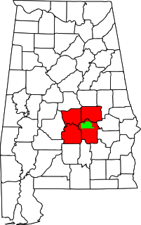
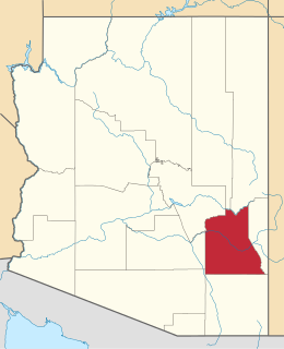
The Talladega-Sylacauga Micropolitan Statistical Area is a micropolitan statistical area that consisted of two counties in Alabama, anchored by the cities of Talladega and Sylacauga, as defined by the United States Census Bureau and the United States Office of Management and Budget. [1] The area is also included in the Birmingham-Hoover-Talladega, Alabama Combined Statistical Area. As of the 2010 census, the μSA had a population of 93,830. [2]
In 2013, the United States Office of Management and Budget added Coosa County to the micropolitan statistical area; it was previously part of the now-defunct Alexander City micropolitan area.
| | This section is empty. You can help by adding to it. (June 2014) |
In the United States, a metropolitan statistical area (MSA) is a geographical region with a relatively high population density at its core and close economic ties throughout the area. Such regions are neither legally incorporated as a city or town would be, nor are they legal administrative divisions like counties or separate entities such as states; because of this, the precise definition of any given metropolitan area can vary with the source. The statistical criteria for a standard metropolitan area were defined in 1949 and redefined as metropolitan statistical area in 1983.

Coosa County is located in the east central portion of the U.S. state of Alabama. As of the 2020 census the population was 10,387. Its county seat is Rockford. Its name derives from a town of the Creek tribe and the Coosa River, which forms one of the county borders.

Talladega County is a county located in the east central portion of the U.S. state of Alabama. As of the 2020 census, the population was 82,149. Its county seat is Talladega.

Goodwater is a town in Coosa County, Alabama, United States. At the 2020 census, the population was 1,291. It is part of the Talladega-Sylacauga Micropolitan Statistical Area.

Rockford is a town in Coosa County, Alabama, United States. At the 2020 census, the population was 349. The town is the county seat of Coosa County and is part of the Talladega-Sylacauga Micropolitan Statistical Area.

Childersburg is a city in Talladega County in the U.S. state of Alabama. It was incorporated in 1889. At the 2020 census, the population was 4,754. It has a history dating back before 1540, when it was noted as a village of the Coosa Nation visited by the Spanish explorer Hernando de Soto. It is said a member of De Soto’s crew fell ill and was left to settle in the area of present day Childersburg where the Coosa people cared for the ill explorer. The Alabama Army Ammunition Plant, important during World War II, was located 4 miles (6 km) north of Childersburg.
Sylacauga is a city in Talladega County, Alabama, United States. At the 2020 census, the population was 12,578.

Alexander City, known to locals as "Alex City", is the largest city in Tallapoosa County, Alabama, United States, with a population of 14,843 as of the 2020 census. It has been the largest community in Tallapoosa County since 1910. It is known for Lake Martin with its 750 miles (1,210 km) of wooded shoreline and 44,000 acres (18,000 ha) of water. Lake Martin stands on the Tallapoosa River and offers boating, swimming, fishing, golfing, and camping. Many neighborhoods and luxury homes are located on the lake.

The U.S. State of Indiana currently has 51 statistical areas that have been delineated by the Office of Management and Budget (OMB). On March 6, 2020, the OMB delineated ten combined statistical areas, 15 metropolitan statistical areas, and 26 micropolitan statistical areas in Indiana.

The U.S. State of Tennessee currently has 34 statistical areas that have been delineated by the Office of Management and Budget (OMB). On March 6, 2020, the OMB delineated seven combined statistical areas, ten metropolitan statistical areas, and 17 micropolitan statistical areas in Tennessee.

The U.S. State of Alabama currently has 36 statistical areas that have been delineated by the Office of Management and Budget (OMB). On March 6, 2020, the OMB delineated nine combined statistical areas, 13 metropolitan statistical areas, and 14 micropolitan statistical areas in Alabama.
The U.S. State of South Carolina currently has 22 statistical areas that have been delineated by the Office of Management and Budget (OMB). On March 6, 2020, the OMB delineated four combined statistical areas, ten metropolitan statistical areas, and eight micropolitan statistical areas in South Carolina.
The Montgomery, Alabama Metropolitan Statistical Area is a metropolitan area in central Alabama. As of 2020, the MSA had a population of 386,047, ranking it 142nd among United States Metropolitan Statistical Areas. That number is up +3.07% from the 2010 census number of 374,536. In September of 2018 the OMB formed the Montgomery-Selma-Alexander City CSA. It's made up of the 4 county Montgomery MSA and the Selma, AL and Alexander City, AL micropolitan areas. The 7 county CSA has a population of 522,873 as of the 2020 census.

The New Bern Metropolitan Statistical Area, as defined by the United States Census Bureau, is an area consisting of three counties in the Inner Banks region of eastern North Carolina, anchored by the city of New Bern. The designation of the area was changed from Micropolitan to Metropolitan in 2013.
The Safford Micropolitan Statistical Area, as defined by the United States Census Bureau, is a micropolitan statistical area (μSA) consisting of one county in eastern Arizona, anchored by the city of Safford.

The Alexander City Micropolitan Statistical Area is a former micropolitan statistical area that consisted of two counties in Alabama, anchored by the city of Alexander City, as defined by the United States Census Bureau. As of the 2010 census, the μSA had a population of 53,155.

Kellyton is an incorporated town in Coosa County, Alabama, United States. It had a population of 217 as of the 2010 census.
The Birmingham metropolitan area, sometimes known as Greater Birmingham, is a metropolitan area in north central Alabama centered on Birmingham, Alabama.
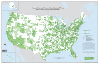
The United States federal government defines and delineates the nation's metropolitan areas for statistical purposes, using a set of standard statistical area definitions. As of 2020, the U.S. Office of Management and Budget (OMB) defined and delineated 392 metropolitan statistical areas (MSAs) and 547 micropolitan statistical areas (μSAs) in the United States and Puerto Rico. Many of these 939 MSAs and μSAs are, in turn, components of larger combined statistical areas (CSAs) consisting of adjacent MSAs and μSAs that are linked by commuting ties; as of 2020, 551 metropolitan and micropolitan areas are components of the 175 defined CSAs. A collective term for MSAs, μSAs, and CSAs is primary statistical areas (PSAs), though that term is not used by OMB.
In the United States, a principal city is the core city or cities in a metropolitan area. The largest city in each metropolitan or micropolitan statistical area is designated a "principal city." Additional cities qualify if specified requirements are met concerning population size and employment. The title of each metropolitan or micropolitan statistical area consists of the names of up to three of its principal cities and the name of each state into which the metropolitan or micropolitan statistical area extends.