Tamrookum Queensland | |||||||||||||||
---|---|---|---|---|---|---|---|---|---|---|---|---|---|---|---|
Coordinates | 28°07′20″S152°54′49″E / 28.1222°S 152.9136°E | ||||||||||||||
Population | 94 (2021 census) [1] | ||||||||||||||
• Density | 4.92/km2 (12.75/sq mi) | ||||||||||||||
Postcode(s) | 4285 | ||||||||||||||
Area | 19.1 km2 (7.4 sq mi) | ||||||||||||||
Time zone | AEST (UTC+10:00) | ||||||||||||||
Location |
| ||||||||||||||
LGA(s) | Scenic Rim Region | ||||||||||||||
State electorate(s) | Scenic Rim | ||||||||||||||
Federal division(s) | Wright | ||||||||||||||
|
Tamrookum is a rural locality in the Scenic Rim Region, Queensland, Australia. [2] In the 2021 census, Tamrookum had a population of 94 people. [1]
The Mount Lindesay Highway traverses Tamrookum from north (Laravale) to south (Innisplain) and forms part of the north-west boundary. The Logan River forms its eastern boundary. [3]
The Sydney–Brisbane rail corridor also passes through the locality from north to south to the west of the highway with Tamrookum railway station at 28°07′10″S152°55′00″E / 28.1194°S 152.9167°E . [3] [4]
A series of vegetated hills in the west rises to elevations of up to 150 metres (490 ft). [3]
In the east adjacent to the river the predominant land use is irrigated cropping and irrigated pasture for grazing. In the west the principal land use is grazing on native vegetation. [3]
The name Tamrookum is believed to be a corruption of the Aboriginal words (from the Yugumbeh language) dhan/buragun meaning place of boomerangs. [2]
The first Tamrookum squatter was John Campbell and the lessee from 1848 was William Barker. In 1872 he paid £ 325 for portion 343 and was issued with a Deed of Grant for 1,000 acres (400 ha) which included the homestead (demolished in 1931) and church site. [5]
Pastoralist John Collins of Mundoolun acquired the land in 1878 and in 1879 his eldest son Robert Martin Collins took up residence after his marriage to Arabella Smyth. RM Collins became the owner in 1886. [5]
RM Collins and his brothers established vast pastoral interests in Queensland and the Northern Territory. He was a founding partner in the North Australian Pastoral Company and a pioneer of the frozen meat industry. He was a parliamentarian from 1896 to 1913 and was responsible for the establishment of Lamington National Park, proclaimed in 1915 after his death. [5]
Following the death of RM Collins in 1913, his family constructed an Anglican church in his memory (Collins had chosen the site prior to his death). All Saint's Memorial Church was dedicated on 31 August 1915 by Archbishop St Clair Donaldson. [6] [7]
Tamrookum State School opened on 31 January 1939. [8]
In October 1944, a meeting of local residents decided to construct memorial hall. [9] However, the project took some years and the Tamrookum Memorial Hall finally opened on 5 April 1952. [10] [11]
In the 2011 census, Tamrookum and surrounds had a population of 266 people. [12]
In the 2016 census, Tamrookum had a population of 91 people. [13]
In the 2021 census, Tamrookum had a population of 94 people. [1]
Tamrookum has a number of heritage-listed sites, including:
Tamrookum State School is a government primary (Prep-6) school for boys and girls at 9019 Mount Lindesay Highway ( 28°06′23″S152°54′56″E / 28.1064°S 152.9155°E ). [15] [16] [17] In 2017, the school had an enrolment of 141 students with 15 teachers (8 full-time equivalent) and 12 non-teaching staff (7 full-time equivalent). [18] There is no government secondary school in Tamrookum; the nearest is Beaudesert State High School in Beaudesert. [3]
Tamrookum has a roadhouse and general store, located on the eastern side of the Mount Lindsay Highway. [19]
Anglican services are held once a month at All Saints Memorial Church at Tamrookum Church Road ( 28°07′25″S152°55′22″E / 28.1236°S 152.9227°E ). [20]
Tamrookum Memorial Hall is on the corner of the Mount Lindesday Highway and Tamrookrum Church Road ( 28°07′24″S152°55′02″E / 28.1233°S 152.9173°E ). [10]
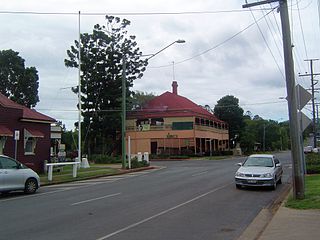
Rathdowney is a rural town and locality in the Scenic Rim Region, Queensland, Australia. In the 2021 census, the locality of Rathdowney had a population of 320 people.
Beaudesert is a rural town and locality in the Scenic Rim Region of Queensland, Australia. In the 2021 census, the locality of Beaudesert had a population of 6,752 people.
Yandina is a rural town and locality in the Sunshine Coast Region, Queensland, Australia. In the 2021 census, the locality of Yandina had a population of 3,073 people.
Toogoolawah is a rural town and locality in the Somerset Region, Queensland, Australia. In the 2021 census, Toogoolawah had a population of 1,200 people.
Marburg is a rural town in the City of Ipswich and a locality split between the City of Ipswich and the Somerset Region, both in Queensland, Australia. In the 2021 census, the locality of Marburg had a population of 1,013 people.
Goomeri is a rural town and locality in the Gympie Region, Queensland, Australia. In the 2021 census, the locality of Goomeri had a population of 677 people.
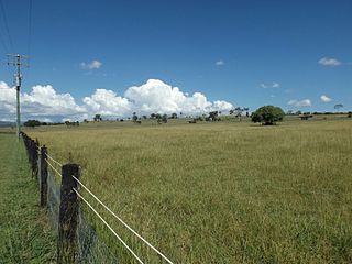
Maroon is a rural locality in the Scenic Rim Region, Queensland, Australia. In the 2021 census, Maroon had a population of 152 people.
Boyland is a rural locality in the Scenic Rim Region, Queensland, Australia. In the 2021 census, Boyland had a population of 855 people.
Coalstoun Lakes is a rural town and locality in the North Burnett Region, Queensland, Australia. In the 2021 census, the locality of Coalstoun Lakes had a population of 99 people.
North Maclean is a locality in the City of Logan, Queensland, Australia. In the 2021 census, North Maclean had a population of 1,581 people.
Cedar Grove is a mixed-use locality in the City of Logan, Queensland, Australia. In the 2021 census, Cedar Grove had a population of 1,992 people.
Tamborine is a rural town in the Scenic Rim Region and a locality split between the Scenic Rim Region and the City of Logan in Queensland, Australia. In the 2021 census, the locality of Tamborine had a population of 4,388 people.
Veresdale is a locality split between the City of Logan and the Scenic Rim Region, Queensland, Australia. In the 2021 census, Veresdale had a population of 414 people.
Laravale is a rural locality in the Scenic Rim Region, Queensland, Australia. In the 2021 census, the locality of Laravale had a population of 185 people.
Josephville is a rural locality in the Scenic Rim Region, Queensland, Australia. In the 2021 census, the locality of Josephville had a population of 172 people.
Palen Creek is a rural locality in the Scenic Rim Region, Queensland, Australia. It borders New South Wales. In the 2021 census, Palen Creek had a population of 368 people.
Sharon is a rural locality in the Bundaberg Region, Queensland, Australia. In the 2021 census, Sharon had a population of 1,209 people.
Innisplain is a rural locality in the Scenic Rim Region, Queensland, Australia. In the 2021 census, Innisplain had a population of 79 people.
Knapp Creek is a rural locality in the Scenic Rim Region, Queensland, Australia. In the 2021 census, Knapp Creek had a population of 59 people.
Gleneagle is a rural locality in the Scenic Rim Region, Queensland, Australia. In the 2021 census, Gleneagle had a population of 2,106 people.
Media related to Tamrookum, Queensland at Wikimedia Commons