Valencia Park, San Diego

Last updated
Valencia Park, San Diego
Valencia Park
Down Division Street.jpg
Down Division Street, facing West, between the neighborhoods of Valencia Park and Alta Vista in Southeast San Diego
Nickname: 
"V.P."
SanDiegoSoutheastMap.gif
Valencia Park is located in the southeastern area of the city of San Diego
Location map Southern San Diego.png
Red pog.svg
Valencia Park, San Diego
Location within San Diego
Coordinates: 32°42′04″N117°04′34″W / 32.701°N 117.076°W / 32.701; -117.076
Country Flag of the United States.svg  United States of America
State Flag of California.svg  California
County San Diego
City San Diego
ZIP Code
92114

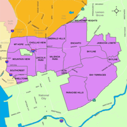
Valencia Park is an urban community in the southeastern section of the city of San Diego, California, United States. It is bordered by Emerald Hills and Market Street on the north, Lincoln Park and Euclid Avenue on the west, Encanto on the east, and Alta Vista and National City, California on the south. Major thoroughfares include Imperial Avenue, Churchward Street, and Valencia Parkway.

Contents

History

Part of the property at Valencia Park Elementary (playground area) was donated by local resident and San Diego Real Estate entrepreneur Astor Basmajian. An earlier resident of this community, Astor bought several pieces of property within Valencia Park as well as property throughout San Diego County. From buying and selling homes that were already there, as well as building a subdivision of new homes within the neighborhood which was later named Astor Heights, he helped contribute to the earlier history of the Valencia Park community. Astor Basmajian, an immigrant from Armenia, escaped the genocide early and became a millionaire twice in his lifetime. A jeweler by trade, he and his brother opened a jewelry shop in New York shortly before World War I. Both brothers served in the war. After returning from the war, Astor continued his business and later moved to Ohio, and then on to California where he remained the rest of his life living out the "American Dream."

With the great influx of Filipino immigrants joining the United States Navy, [1] especially from the Vietnam War era on to the 1990s, many Filipinos inhabited the Southeast San Diego neighborhoods of Alta Vista, Bay Terraces, Paradise Hills, Shelltown, Skyline Hills, and Valencia Park, both for the relatively affordable housing prices and its close proximity to Naval Base San Diego. [2]

Demographics

Valencia Park is a diverse community with one of the most significant African-American populations in the City. Current demographics for the neighborhood are as follows: people of Hispanic heritage make up 52.6%, followed by African-American at 26.4%, then Asian at 15.6%, non-Hispanic Whites at 3.4%, Mixed Race at 2.0% and others at 0.1%. [3] It ranked near the very bottom at 121 out of 125 San Diego neighborhoods in terms of lowest percentage of non-Hispanic whites, and 4 out of 125 San Diego neighborhoods in terms of total population that is non-White (roughly 96.6%), topped only by bordering Lincoln Park, San Ysidro, and Southcrest. [4]

Landmarks and facilities

Valencia Park shares Market Creek Plaza, a shopping center, with neighboring Lincoln Park.

A portion of Chollas Creek runs through Valencia Park. [5]

Education

Valencia Park is served by the San Diego Unified School District. Public schools in Valencia Park include Valencia Park Elementary School, Nye Elementary School, Lincoln High School in bordering Lincoln Park, Morse High School in nearby Skyline, and The O'Farrell Charter Schools, an organization of charter schools located in bordering O'Farrell Park.

Much like the rest of Southeast San Diego, many students in Valencia Park have taken advantage of San Diego Unified School District's Voluntary Enrollment Exchange Program (VEEP), and have opted to be bused to high schools in San Diego's more affluent northern suburban neighborhoods,. [6] Depending on their VEEP Allied School Pattern, a high school student may be voluntarily bused to Mira Mesa High School, Mission Bay High School, Scripps Ranch High School, Serra High School, and University City High School. [7]

See also

Related Research Articles

<span class="mw-page-title-main">Canyon Country, Santa Clarita, California</span> Neighborhood of Santa Clarita, California

Canyon Country is a neighborhood in the eastern part of the city of Santa Clarita, in northwestern Los Angeles County, California, United States. It lies along the Santa Clara River between the Sierra Pelona Mountains and the San Gabriel Mountains. It is the most populous of Santa Clarita's four neighborhoods.

<span class="mw-page-title-main">Logan Heights, San Diego</span> Community of San Diego in California

Logan Heights is an urban neighborhood in central San Diego, California. It is bordered by Interstate 5 on the south and west, Interstate 15 on the east, and Imperial Avenue on the north. It is part of the Southeastern Planning Area.

<span class="mw-page-title-main">Paradise Hills, San Diego</span> Community of San Diego in California

Paradise Hills is an urban neighborhood in the southeastern area of the city of San Diego, California. It is an outlying neighborhood adjacent to the independent city of National City and the unincorporated communities of Lincoln Acres and certain portions of Bonita. The neighborhood is part of the Skyline-Paradise Hills Community Planning Area.

<span class="mw-page-title-main">Encanto, San Diego</span> Community of San Diego in California

Encanto is a hilly urban neighborhood located in the southeastern region of San Diego, California. The neighborhood is bordered by California State Route 94 and the communities of Oak Park and Broadway Heights to the north, O'Farrell to the south, Emerald Hills and Valencia Park to the west and the City of Lemon Grove to the east.

<span class="mw-page-title-main">Oak Park, San Diego</span> Community of San Diego in California

Oak Park is an urban neighborhood of the Southeast region of San Diego, California.

<span class="mw-page-title-main">Southeast San Diego</span> Community of San Diego in California

Southeast San Diego refers to the southeastern portion of the City of San Diego, including the neighborhoods south of State Route 94 and east of Downtown San Diego. Southeast San Diego has no official definition, but it may be considered coterminous with three official planning areas: Skyline-Paradise Hills, Encanto Neighborhoods, and Southeastern.

The O'Farrell Charter Schools is a system of public charter schools on a campus in San Diego, California. The school opened its doors in the San Diego Unified School District in 1959 chosen in 1957 as Mabel E. O'Farrell Junior High. It was voted to become a charter school in 1994. President Bill Clinton made a visit to San Diego in 1995 to sign the Goals 2000 education bill and to visit O'Farrell because it was a charter. It was also mentioned in Hillary Clinton's book It Takes a Village. Through the years, The O'Farrell Charter School has received numerous awards and distinctions. The O'Farrell Charter High School has been named as one of America's top high schools by U.S. News and World report six years in a row. O'Farrell has also been named a school of distinction by National Center for Urban School Transformation. O'Farrell is an AVID National Demonstration School.

<span class="mw-page-title-main">Alta Vista, San Diego</span> Community of San Diego in California

Alta Vista is a small neighborhood in southeastern San Diego, California, United States. It is bordered by National City to the west, Bay Terraces to the east, Encanto and Valencia Park to the north.

<span class="mw-page-title-main">Shelltown, San Diego</span> Community of San Diego in California

Shelltown is a neighborhood located within Southeast San Diego, approximately 5 minutes from downtown San Diego by car and 25 minutes by bicycle. It is bordered by National City on the south, Interstate 5 and Barrio Logan on the west, 43rd Avenue on the east, and Gamma Court and the neighborhood of Southcrest on the north. Prior to the 1980s the northern border of Shelltown was National Ave and many residents still consider that the northern border.

<span class="mw-page-title-main">Mountain View, San Diego</span> Community of San Diego in California

Mountain View is an urban community in the southeastern section of the city of San Diego. It is bordered by Mount Hope and Greenwood Memorial Park on the north, Interstate 15 and the neighborhoods of Stockton and Logan Heights on the west, Interstate 805 and Lincoln Park on the east, and Southcrest and National City on the south. Major thoroughfares include Imperial Avenue and Ocean View Boulevard.

<span class="mw-page-title-main">Southcrest, San Diego</span> Community of San Diego in California

Southcrest is an urban community in the southeastern section of the city of San Diego. It is bordered by Mountain View on the north and east, Interstate 5 and the neighborhoods of Barrio Logan and Logan Heights on the west, and Shelltown on the south. Major thoroughfares include National Avenue and 40th Street.

<span class="mw-page-title-main">Chollas View, San Diego</span> Neighborhood in San Diego, California

Chollas View is an urban community in the southeastern section of the city of San Diego. It is bordered by Webster and California State Route 94 on the north, Mount Hope and Interstate 805 on the west, Emerald Hills and Euclid Avenue on the east, and Lincoln Park and the San Diego Trolley on the south. Major thoroughfares include Market Street and 47th Street.

<span class="mw-page-title-main">Lincoln Park, San Diego</span> Community of San Diego in California

Lincoln Park is an urban community in the southeastern section of San Diego, California. It is bordered by Chollas View and the San Diego Trolley on the north, Mountain View and Interstate 805 on the west, Valencia Park and Euclid Avenue on the east, and National City, California on the south. Major thoroughfares include Imperial Avenue, Ocean View Boulevard, and Logan Avenue.

<span class="mw-page-title-main">Emerald Hills, San Diego</span> Community of San Diego in California

Emerald Hills is a neighborhood in the southeastern section of the city of San Diego, California, United States. It is bordered by Oak Park and California State Route 94 on the north, Chollas View and Euclid Avenue on the west, Encanto and Skyline Drive on the east, and Valencia Park and Market Street on the south. Major thoroughfares include Kelton Road and Roswell Street.

<span class="mw-page-title-main">2002 San Diego City Council election</span>

The 2002 San Diego City Council election occurred on November 5, 2002. The primary election was held on March 5, 2002. Four of the eight seats of the San Diego City Council were contested. Two incumbent council members stood for reelection after having previously been elected to partial terms.

<span class="mw-page-title-main">Skyline, San Diego</span> Community of San Diego in California

Skyline, also known as Skyline Hills or Skyline Park, is a hilly urban neighborhood in Southeastern San Diego. It is bordered by Encanto to the west, Jamacha-Lomita to the North East, and Bay Terraces to the South. The neighborhood is split into two sections, Skyline West and Skyline East. The neighborhood is part of the Skyline-Paradise Hills Community Planning Area.

<span class="mw-page-title-main">Bay Terraces, San Diego</span> Community of San Diego in California

Bay Terraces is a hilly urban neighborhood in the southeastern part of San Diego, California, United States. A composite of North Bay Terrace and South Bay Terrace, it is bordered by Skyline to the north, Paradise Hills to the southwest, Alta Vista, South Encanto and National City to the west. The southern end of the neighborhood is bordered by State Route 54 and Bonita. The neighborhood generally includes the ZIP Codes 92114 and 92139 and as such, parts of the area have often been incorrectly referred to as either "Paradise Hills" or "Skyline Hills" due to its proximity and overlapping ZIP Codes. Nevertheless, Bay Terraces is the largest neighborhood in the Skyline-Paradise Hills Community Planning Area.

<span class="mw-page-title-main">Lomita, San Diego</span> Community of San Diego in California

Lomita, also known as Lomita Village, is an urban neighborhood in the southeastern area of San Diego, California. It is bounded by Meadowbrook Drive and Skyline West to the west, unincorporated La Presa to the east and Skyline East to the south, and Jamacha to the north. Major thoroughfares in the neighborhood include San Vicente Street and Worthington Avenue. The neighborhood is part of the Skyline-Paradise Hills Community Planning Area.

<span class="mw-page-title-main">Jamacha, San Diego</span> Community of San Diego in California

Jamacha is a neighborhood in the southeastern area of San Diego, California. It is generally bounded by the city of Lemon Grove to the north, unincorporated La Presa to the east, Imperial Avenue and Encanto to the west, and Skyline and Lomita Village to the south. Major thoroughfares include Lisbon Street, Jamacha Road, and Woodrow Avenue. The neighborhood is part of the Skyline-Paradise Hills Community Planning Area.

<span class="mw-page-title-main">O'Farrell, San Diego</span> Community of San Diego in California

O'Farrell is the name of the urban region in Southeast San Diego that includes portions of Skyline, Encanto and Valencia Park. The area borders North Bay Terraces to the east and Alta Vista to the south.

References

  1. "Journal of San Diego History" . Retrieved 2007-11-17.
  2. "San Diego Reader - Their Own Paradise" . Retrieved 2020-11-17.
  3. ""Race and Ethnicity in Lincoln Park, San Diego, California"". Statistical Atlas. Retrieved 2020-11-20.
  4. ""Race and Ethnicity in Lincoln Park, San Diego, California"". Statistical Atlas. Retrieved 2020-11-20.
  5. "Southeastern San Diego Community Plan" (PDF).
  6. "VEEP Information". Archived from the original on 2007-12-10. Retrieved 2007-11-17.
  7. "2007–2008 VEEP Allied Patterns" (PDF). Archived from the original (PDF) on 2008-05-02. Retrieved 2007-11-17.

32°42′04″N117°04′34″W / 32.701°N 117.076°W / 32.701; -117.076