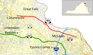
State Route 193 is a primary state highway in the U.S. state of Virginia. Known as Georgetown Pike, the state highway runs 11.79 mi (18.97 km) from SR 7 in Dranesville east to SR 123 in Langley. SR 193 passes through Great Falls and meets Interstate 495 (I-495) in McLean. The state highway was designated the first Virginia Byway for its scenic value in 1974.

The Thomas Viaduct spans the Patapsco River and Patapsco Valley between Relay, Maryland and Elkridge, Maryland, USA. It was commissioned by the Baltimore and Ohio Railroad (B&O); built between July 4, 1833, and July 4, 1835; and named for Philip E. Thomas, the company's first president. It remains the world's oldest multiple arched stone railroad bridge.
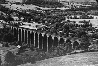
Starrucca Viaduct is a stone arch bridge that spans Starrucca Creek near Lanesboro, Pennsylvania, in the United States. Completed in 1848 at a cost of $320,000, it was at the time the world's largest stone railway viaduct and was thought to be the most expensive railway bridge as well. Still in use, the viaduct is listed on the National Register of Historic Places and is designated as a National Historic Civil Engineering Landmark.

Canton Viaduct is a blind arcade cavity wall railroad viaduct in Canton, Massachusetts, built in 1834–35 for the Boston and Providence Railroad (B&P).

Choate Bridge (1764) is a historic stone arch bridge carrying Route 1A/Route 133 over the Ipswich River in Ipswich, Massachusetts. It is one of the oldest surviving bridges in North America, and is probably the oldest in Massachusetts. It was listed on the National Register of Historic Places in 1972 and also has been designated as a National Historic Civil Engineering Landmark.

The Arrawanna Bridge is a historic bridge, spanning the Coginchaug River near Berlin Street in Middletown, Connecticut, USA. Built in 1918, it is an early example in the state of an open-spandrel concrete arch bridge, and is one of the state's oldest bridges. It was listed on the National Register of Historic Places in 2004. The bridge is now closed to all traffic.

The East Putney Brook Stone Arch Bridge is a historic stone arch bridge in eastern Putney, Vermont. Built in 1902, it is a rare statewide example of a 20th-century stone bridge, and one of a number of such area bridges built by Townshend farmer and mason James Otis Follett. It was listed on the U.S. National Register of Historic Places in 1976. The bridge is located just west (upstream) of the present alignment of River Road, which it formerly carried.

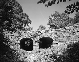
Valley Railroad Stone Bridge is a historic stone arch bridge spanning Folly Mills Creek near Jolivue, Augusta County, Virginia. It was built in 1874 by the Valley Railroad, and is a four-span structure with an overall length of 130 feet (40 m) and a width of 15 feet (4.6 m). It is constructed of granite and faced in ashlar and features semi-circular arches set on gently splayed piers. It was acquired by the Virginia Department of Transportation in 1965. It is considered a scenic landmark along Interstate 81.

The Stone Arch Bridge is a stone arch railroad bridge in Keene, New Hampshire, United States. Built in 1847 to carry the Cheshire Railroad, it is one of the best-preserved pre-1850 stone arch bridges in the nation. The bridge was listed on the National Register of Historic Places in 2012, and the New Hampshire State Register of Historic Places in 2006. It now carries a multi-purpose rail trail.
The Mulladay Hollow Bridge is a stone arch bridge in rural Carroll County, Arkansas. It carries County Road 204 across Mulladay Hollow Creek, near the southwestern tip of Lake Leatherwood It has two spans, and is built out of roughly square and semi-coursed fieldstone. The arches are elliptical in shape, 9 feet (2.7 m) in height and 9.5 feet (2.9 m) wide, with nearly-square voussoirs forming the arches. The barrels of the arches are skewed with respect to the spandrels, and the wing walls are slightly curved. The roadway carried by the bridge is 30 feet (9.1 m) wide, and the total length of the structure is 120 feet (37 m). The bridge was built with Works Progress Administration funding as part of the development of Lake Leatherwood as a recreation area.

The Sacketts Brook Stone Arch Bridge, also known locally as the Hi-Lo Biddy Stone Arch Bridge, is a historic bridge just outside the village of Putney, Vermont. It is a stone arch bridge that formerly carried Mill Street across Sacketts Brook, about 0.25 miles (0.40 km) east of United States Route 5. It was built in 1906 by James Otis Follett, an area stonemason, and is one of a few surviving examples of his work. The bridge was listed on the National Register of Historic Places in 1976.
The Simpsonville Stone Arch Bridge is a historic stone arch bridge, carrying Vermont Route 35 across Simpson Brook, north of the village of Townshend, Vermont. Built about 1909, it is one of a few surviving bridges in the region built by local mason James Otis Follett. It was listed on the National Register of Historic Places in 1977.

The West Townshend Stone Arch Bridge carries Round Hill Road across Tannery Brook in the village of West Townshend, Vermont. Built about 1910, it is one of the few surviving bridges of a group built by local mason James Otis Follett in the early 20th century. It was listed on the National Register of Historic Places in 1977.

The Colburn Bridge is a historic bridge in Pittsford, Vermont. It is a masonry arch bridge, carrying U.S. Route 7 (US 7) across Sugar Hollow Brook a short way east of the town center. Built in 1899, it is one of a modest number of surviving masonry arch bridges in the state, and exhibits particularly high quality period workmanship. It was listed on the National Register of Historic Places in 1990.

The Steyer Bridge is a historic structure located on the west side of Decorah, Iowa, United States. This is one of the few stone arch bridges that continue to exist in Iowa. It was constructed by local stonemason Michael Steyer over Twin Springs Creek in 1875. Steyer emigrated from Germany in 1867, and settled in Decorah. His brother Joseph was the proprietor of the Steyer Opera House in town. Compared to other stone bridges in the state, this one is less sophisticated and is a good example of vernacular engineering. It is a small structure that consists of a single arch that is formed by rough-cut limestone voussoirs. The keystone is a block of dressed limestone with Steyer's name and the date "1875" carved on it. The spandrels and the walls that form the foundation for the approaches to the bridge consist of coursed rubble limestone. The base of the walls and the lower edges of the arch were reinforced with concrete in the 1970s. The concrete bridge deck is edged with wooden posts. When U.S. Route 52 was relocated to this area in the early 1970s, the Steyer Bridge was scheduled to be removed, but local protests saved it and the highway bridge built over it. The bridge listed on the National Register of Historic Places in 1983.

The Quechee Gorge Bridge is a historic bridge, carrying U.S. Route 4 (US 4) across Quechee Gorge, near the Quechee village of Hartford, Vermont. Built in 1911, it is Vermont's oldest surviving steel arch bridge. It was listed on the National Register of Historic Places in 1990.

The State Street Bridge is a historic structure located in Mason City, Iowa, United States. The span carries East State Street over Willow Creek for 62 feet (19 m). In the mid- to late-19th century, State Street was the only road into town from the east. There was a bridge at this crossing from at least 1875, but it is unknown what kind of bridges or how many served the crossing. Completed in 1903, this bridge features a barrel arch with filled spandrels. Although the original guardrails have been replaced, it is the oldest roadway arch bridge in Cerro Gordo County. It was listed on the National Register of Historic Places in 1998.

The Landers Creek Bridge, also known as the Goodrich Bridge and located at the southern edge of Goodrich in Linn County, Kansas, is a stone arch bridge which was built in 1917. It was listed on the National Register of Historic Places in 1985.

The West Sixth Street Bridge is a historic stone arch bridge in downtown Austin, Texas. Built in 1887, the bridge is one of the state's oldest masonry arch bridges. It is located at the site of the first bridge in Austin, carrying Sixth Street across Shoal Creek to link the western and central parts of the old city. The bridge was added to the National Register of Historic Places in 2014.

The San Jacinto Street Bridge is a viaduct which crosses Buffalo Bayou in Houston, Texas. The structure is listed on the National Register of Historic Places (NRHP). This bridge was built in 1914 to replace an iron pivot bridge of 1883 origin, and rehabilitated in 1997. It is a transportation conduit connecting downtown and the historical Fifth Ward.


