
The Hotchkissville Historic District is a historic district in the town of Woodbury, Connecticut, that was listed on the National Register of Historic Places in 1995. The district encompasses most of the historic village of Hotchkissville, which is centered at the junction of Washington and Weekeepeemee roads. The village began as a dispersed rural agricultural community, but developed in the 19th century with the arrival of industry, primarily the manufacture of textiles. Despite this, the village has retained a significantly rural character, and includes a broad cross-section of 18th- and 19th-century architectural styles.
The North Chester Historic District is a historic district encompassing the rural village center of North Chester in the town of Chester, Massachusetts. One of the rural community's early settlement nodes, it thrived into the early 19th century around a stagecoach tavern, a few small mills, and farming, and retains buildings and archaeological remains representative of this history. The district was listed on the National Register of Historic Places in 1998.

The Old Mill Site Historic District in Hatfield, Massachusetts encompasses the site of a late 19th century mill. It is one of only two such sites in the town. The centerpiece of the district is the former Shattuck Gun Factory building, which in 1989 housed newspaper offices and in 2006 a bed and breakfast. The district, which was listed on the National Register of Historic Places in 1982, includes three other elements: an 1891 Warren pony truss bridge across the Mill River, now closed to traffic, and a machine shop and garage, both built in 1886. The district was also included in the larger Mill-Prospect Street Historic District in 2002.

The Skaneateles Historic District is a 17 acres (6.9 ha) historic district in the village of Skaneateles, New York that dates back to 1796, includes one building from the 20th century, but is otherwise composed of 19th-century residences and commercial buildings. It includes 59 contributing buildings and one contributing site – Thayer Park along Skaneateles Lake, – as well as five non-contributing structures. The district runs along both sides of East Genesee Street from Jordan Street to Onondaga Street, and includes the core of Skaneateles' historic downtown area, which was rebuilt in 1836 after being almost totally destroyed by fire in 1835. Also included are properties on Jordan Street up to the intersection of Fennell Street, and the stone mill property on Fennell Street.

Hanford Mills Museum, also known as Kelso Mill, is a historic grist mill and sawmill and national historic district located at East Meredith, New York in Delaware County, New York. The district contains nine contributing buildings and three contributing structures. The complex includes both natural and structural facilities. It includes a mill race from Kortright Creek to the damned up Mill Pond which supplies the waterwheel, a spillway for the pond's overflow, a section of old (1900) New York Central Railroad track, two railroad bridges crossing Kortright Creek, and a variety of buildings. The main structure is a mill building dating to the 1820s with additions from the 1870s, 1880s, and 1890s. The four story wood-frame structure is approximately 150 feet long and 120 feet high. Also on the property is a one-story depot building with grain elevator and storage facilities. It is now operated as a museum. It was listed on the National Register of Historic Places in 1973.

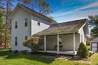
Hubbell Family Farm and Kelly's Corners Cemetery is a historic farm complex, cemetery, and national historic district located at Kelly's Corners, Delaware County, New York. The district contains 19 contributing buildings, two contributing sites, and four contributing structures.

South Otselic Historic District is a national historic district located at South Otselic in Chenango County, New York. The district includes 60 contributing buildings. It encompasses the hamlet's historic core and includes commercial, residential, ecclesiastical, and industrial buildings. Among the notable buildings are the Methodist Church, Gladding Corporation factory and office (1895), J. Brown Grist Mill, Noonan's Blacksmith Shop (1870), Cox Block, and Dew Drop Building. Notable residences include the Octagon House and the Queen Anne style Former Gladding Mansion.
Riders Mills Historic District is a national historic district located at Chatham in Columbia County, New York. The district includes 20 contributing buildings, eight contributing structures, and one contributing site. It includes the remnants of the one thriving hamlet of Riders Mills, located along the Kinderhook Creek and largely wiped out by a flood in 1869. Most of the buildings are residential and date to the early to mid-19th century and reflect a variety of popular architectural styles such as Georgian and Greek Revival. In addition to residences, the district includes a schoolhouse and bridge. There are also eight known archaeological sites, mostly the foundations of mills and residences.
Warrensburg is a town in Warren County, New York, United States. It is centrally located in the county, west of Lake George. It is part of the Glens Falls metropolitan area. The town population was 3,959 at the 2020 census. While the county is named after General Joseph Warren, the town is named after James Warren, a prominent early settler. U.S. Route 9 passes through the town, which is immediately west of Interstate 87.

Hamlet of Warrensburgh Historic District is a national historic district located at Warrensburg, Warren County, New York. It includes 351 contributing buildings, three contributing sites, and five contributing structures. It encompasses the historic commercial core on the north side of the Schroon River and historic industrial core on the south side of the river of the hamlet of Warrensburgh. It includes more high styled residences and notable civic and religious properties on the north side and vernacular residences on the south side. Notable commercial buildings include the Woodward Block, Wills Block, bank building at 138 Main Street, and the former Sturdevan's Bakery. Three historic churches within the district are the Church of the Holy Cross (1864), First Methodist Church (1904), and United Presbyterian Church (1840). Civic buildings located within the district are the Richards Library (1900) and Warrensburgh Central School (1942). In addition, the Floyd Bennett Park and Bandstand (1930–31), named for Warrensburg native Floyd Bennett, is within the district.
Upper–Mill Street Historic District is a national historic district located at Poughkeepsie, Dutchess County, New York. It includes 25 contributing buildings built during the mid- to late-19th century. They include a variety of brick and frame buildings, originally residential, that have been converted to office and other commercial use. They are representative of vernacular mill workers' dwellings and fashionable factory owners' residences. The district also includes two churches.

The Bennington Village Historic District of Bennington, New Hampshire encompasses the 19th-century center of the village. Growth of the village followed a typical pattern for rural New Hampshire towns, based in this case around the growth in the early 19th century of the paper industry, which continues to be a significant economic force in the community. The district is centered on the junctions of Main, Center, and School Streets with Bible Hill Road and Francestown Road. The district was listed on the National Register of Historic Places in 2010.
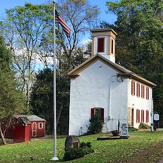
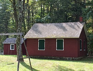
The New Hampton Historic District is a 76-acre (31 ha) historic district in the village of New Hampton in Lebanon Township in Hunterdon County, New Jersey, United States. The district was added to the National Register of Historic Places on April 6, 1998, for its significance in architecture, commerce, education, transportation, and community development from c. 1780 to 1929. It includes 42 contributing buildings, six contributing sites, and four contributing structures located along Musconetcong River Road.

The Kingston Mill Historic District is a 49-acre (20 ha) historic district in Kingston, New Jersey. It is roughly bounded by the Millstone, River, and Princeton-Kingston Roads in the townships of Princeton in Mercer County, South Brunswick in Middlesex County, and Franklin in Somerset County. It was added to the National Register of Historic Places on April 10, 1986 for its significance in engineering, exploration/settlement, industry, and transportation. The district includes 16 contributing buildings and 2 contributing structures.

The Falls of Rough Historic District, along Kentucky Route 110 in Falls of Rough, Kentucky, is a 50 acres (20 ha) historic district which was listed on the National Register of Historic Places in 1978. It included 10 contributing buildings, a contributing structure, and three contributing sites.

The Asbury Historic District is a 288-acre (117 ha) historic district encompassing the community of Asbury in Franklin Township of Warren County, New Jersey. It is bounded by County Route 632, County Route 643, Maple Avenue, Kitchen Road, and School Street and extends along the Musconetcong River into Bethlehem Township of Hunterdon County. It was listed on the National Register of Historic Places on March 19, 1993 for its significance in architecture, industry, religion, community development, politics/government, and commerce. The district includes 141 contributing buildings, a contributing structure, two contributing sites, and four contributing objects.

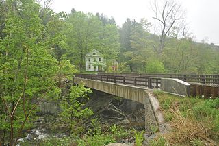
The New Hampton Pony Pratt Truss Bridge is a historic pony Pratt truss bridge on Shoddy Mill Road in New Hampton of Lebanon Township, Hunterdon County, New Jersey. It crosses the Musconetcong River between Lebanon Township, Hunterdon County and Washington Township, Warren County. It was designed by Francis C. Lowthorp and built in 1868 by William Cowin of Lambertville, New Jersey. The bridge was added to the National Register of Historic Places on July 26, 1977 for its significance in engineering, industry and transportation. It is one of the few early examples of iron Pratt truss bridges remaining in the United States. It was later documented by the Historic American Engineering Record in 1991. It was added as a contributing property to the New Hampton Historic District on April 6, 1998.

The Imlaydale Historic District is a 32-acre (13 ha) historic district primarily in Washington Township of Warren County, New Jersey. It was added to the National Register of Historic Places on March 27, 1991 for its significance in architecture, community development, industry, politics/government, and transportation. The listing includes 12 contributing buildings, four contributing structures, and two contributing sites.
The Fallasburg Historic District is a historic district containing the remaining portions of a nineteenth century hamlet surrounding the remains of a sawmill and gristmill. The district is located near the Fallasburg Bridge, where Covered Bridge Road crosses the Flat River in Vergennes Township, Michigan. It was listed on the National Register of Historic Places in 1999.

Millville is an unincorporated community located along River Road and Shimers Brook in Montague Township of Sussex County, New Jersey. The Montague Grange and other parts of the community are in the Delaware Water Gap National Recreation Area.


