Mount Whitney is the tallest mountain in the contiguous United States and the Sierra Nevada, with an elevation of 14,505 feet (4,421 m). It is located in East–Central California, on the boundary between California's Inyo and Tulare counties, 84.6 miles (136.2 km) west-northwest of the lowest point in North America at Badwater Basin in Death Valley National Park at 282 ft (86 m) below sea level. The west slope of the mountain is in Sequoia National Park and the summit is the southern terminus of the John Muir Trail which runs 211.9 mi (341.0 km) from Happy Isles in Yosemite Valley. The east slope is in the Inyo National Forest in Inyo County.

The John Muir Wilderness is a wilderness area that extends along the crest of the Sierra Nevada of California for 90 miles (140 km), in the Inyo and Sierra National Forests. Established in 1964 by the Wilderness Act and named for naturalist John Muir, it contains 581,000 acres (2,350 km2). The wilderness lies along the eastern escarpment of the Sierra from near Mammoth Lakes and Devils Postpile National Monument in the north, to Cottonwood Pass near Mount Whitney in the south. The wilderness area also spans the Sierra crest north of Kings Canyon National Park, and extends on the west side of the park down to the Monarch Wilderness.
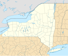
The Tioughnioga River is a 34.2-mile-long (55.0 km) tributary of the Chenango River in central New York in the United States. It drains a dissected plateau area east of the Finger Lakes at the northernmost edge of the watershed of the Susquehanna River.
The Otselic River(aht-SEEL-ik), formerly known as Otselic Creek is a 55.4-mile-long (89.2 km) tributary of the Tioughnioga River in central New York in the United States. It drains a hilly area, mostly forested and agricultural, east of the Finger Lakes at the northern edge of the Susquehanna River watershed.

The Tule River, also called Rio de San Pedro or Rio San Pedro, is a 71.4-mile (114.9 km) river in Tulare County in the U.S. state of California. The river originates in the Sierra Nevada east of Porterville and consists of three forks, North, Middle and South. The North Fork and Middle Fork meet above Springville. The South Fork meets the others at Lake Success. Downstream of Success Dam, the river flows west through Porterville. The river used to empty into Tulare Lake, but its waters have been diverted for irrigation. However, the river does reach Tulare Lake during floods. Tulare Lake is the terminal sink of an endorheic basin that historically also received the Kaweah and Kern Rivers as well as southern distributaries of the Kings.

The Mayacamas Mountains are located in northwestern California in the United States. The mountain range is part of the Northern Inner Coast Ranges, of the California Coast Ranges System.

Mount Russell is a peak in the Sierra Nevada mountain range in the U.S. state of California, about 0.8 miles (1.3 km) north of Mount Whitney. It rises to an elevation of 14,094 feet (4,296 m) and is the seventh-highest peak in the state.

Lake Burton is a 2,775 acre (11.23 km²) reservoir with 62 miles (100 km) of shoreline located in the northeastern corner of Georgia in Rabun County. It is the first lake in a six-lake series called the Tallulah River Watershed that follows the original course of the Tallulah River. The chain begins with Lake Burton as the northernmost lake followed by Lake Seed, Lake Rabun, Lake Tallulah Falls, Lake Tugalo, and Lake Yonah. The lakes are owned and operated by the Georgia Power Company to generate hydroelectric energy for Georgia's largest city, Atlanta. At one time these lakes were the largest producers of electricity in the state of Georgia. At present the lakes provide power only during periods of peak electricity consumption.

The Mount Whitney Trail is a trail that climbs Mount Whitney. It starts at Whitney Portal, 13 miles (21 km) west of the town of Lone Pine, California. The hike is about 22 mi (35 km) round trip, with an elevation gain of over 6,100 feet (1,860 m). It is an extremely popular trail, and its access is restricted by quotas from May to October.

Rush Creek is a 27.2-mile-long (43.8 km) creek in California on the eastern slope of the Sierra Nevada, running east and then northeast to Mono Lake. Rush Creek is the largest stream in the Mono Basin, carrying 41% of the total runoff. It was extensively diverted by the Los Angeles Aqueduct system in the twentieth century until California Trout, Inc., the National Audubon Society, and the Mono Lake Committee sued Los Angeles Department of Water and Power (LADWP) for continuous low flows in Rush Creek to maintain trout populations in good condition, which was ordered by the court in 1985.

Lake Whitney Ranch is a 876-acre (3.55 km2) property near Whitney, Texas that is under development as a summer youth camp, Pathfinder camp, church camp and conference center for the Texas Conference of Seventh-day Adventists.

The Mount Whitney Fish Hatchery, located in Independence, California, in the United States, is an historic fish hatchery that has played an important role in the preservation of the golden trout, California's state fish.

The MacFarlane River is a river in Unorganized Kenora District in northwestern Ontario, Canada and a tributary of the Winnipeg River. Locally it has been called the "Black River", a reference to the dark tannin stained water.
Golden Trout Creek is an approximately 9-mile (14 km) long tributary of the Kern River, flowing in northeastern Tulare County, California.

Mount Gabb is in the central Sierra Nevada in the U.S. state of California. Mount Gabb is in the John Muir Wilderness of Sierra National Forest and is named after William More Gabb, a paleontologist and member of the Whitney Survey.