Windcrest, Texas

Last updated

Windcrest, Texas
Nickname: 
City of Lights
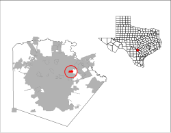
TXMap-doton-Windcrest.PNG
Location of Windcrest, Texas
Bexar Windcrest.svg
Coordinates: 29°30′57″N98°22′47″W / 29.51583°N 98.37972°W / 29.51583; -98.37972
Country United States
State Texas
County Bexar
Government
  Type Council-Manager
   City Council Mayor Dan Reese
Susie Hamilton
Cindy Strzelecki, Mayor Pro Tem
Greg Turner
Marcus Yax
Adam Astleford
   City Manager Rafael Castillo
Area
[1]
  Total
2.15 sq mi (5.58 km2)
  Land2.15 sq mi (5.57 km2)
  Water0.01 sq mi (0.01 km2)
Elevation
[2]
791 ft (241 m)
Population
 (2020)
  Total
5,865
  Density2,733.02/sq mi (1,055.37/km2)
Time zone UTC-6 (Central (CST))
  Summer (DST) UTC-5 (CDT)
ZIP code
78239
Area code(s) 210, 726 (planned)
FIPS code 48-79672 [3]
GNIS feature ID1350289 [2]
ANSI Code2412280 [4]
Website www.ci.windcrest.tx.us

Windcrest is a city in Bexar County, Texas, United States. Its population was 5,865 at the 2020 census. [5] It is part of the San Antonio metropolitan area.

Contents

Geography

Windcrest is located in northeastern Bexar County. It is bordered to the north, west, and south by San Antonio and to the east by unincorporated neighborhoods in Bexar County. It is 11 miles (18 km) northeast of downtown San Antonio.

According to the United States Census Bureau, it has a total area of 2.2 square miles (5.6 km2), of which 0.004 square miles (0.01 km2), or 0.23%, is covered by water. [5]

Demographics

Historical population
CensusPop.Note
1960 441
1970 3,371664.4%
1980 5,33258.2%
1990 5,3310.0%
2000 5,105−4.2%
2010 5,3645.1%
2020 5,8659.3%
U.S. Decennial Census [6]
Windcrest racial composition as of 2020 [7]
(NH = Non-Hispanic) [a]
RaceNumberPercentage
White (NH)2,68146.7%
Black or African American (NH)66912.1%
Native American or Alaska Native (NH)210.4%
Asian (NH)2365%
Pacific Islander (NH)80%
Some other race (NH)210.36%
Mixed/multiracial (NH)1933.29%
Hispanic or Latino 2,03632.8%
Total5,865

As of the 2020 United States census, there were 5,865 people, 1,903 households, and 1,317 families residing in the city.

As of the census [3] of 2020, 5,865 people, 2.389 households, and -- families were residing in the city. The population density was 2,727.9 inhabitants per square mile (1,053.2/km2).\ The racial makeup of the city was 46.7% White alone (not Hispanic or Latino), 32.8% Hispanic or Latino, 12.1% African American, 0.4% American Indian and Alaska Native alone, 5% Asian, 0% Pacific Islander, and 17.9% were Two or More races,. The census reported 941 Veterans and that 10.6% of the population were foreign born persons.

Of the 2,389 households, 10.8% had children under 18 living with them, with 3.5% under the age of 5. 39.4% had someone who was 65 or older, and 54.6% of households held female persons. The average household size was 2.38. 22.1% of households had persons over 5 who spoke a language other than English in the home.

97.4% of households had a computer, and 96.1% had a broadband access subscription.

The median income for a household in the city was $95,329 (in 2023 dollars). The per capita income for the city in the past 12 months was $53,595 (in 2023 dollars). 9.2% of the population were below the poverty line, nearly half the percentage of neighboring San Antonio. The median value of owner occupied housing units was $276,900 (2019-2023).

Education

The city is served by North East Independent School District. [10]

Zoned schools include: [11] Windcrest Elementary School in Windcrest, [12] Ed White Middle School in San Antonio, [13] and Roosevelt High School in San Antonio. [14]

Area charter schools include Premier High School and Compass Rose Journey.

Related Research Articles

<span class="mw-page-title-main">Bexar County, Texas</span> County in Texas, United States

Bexar County is a county in the U.S. state of Texas. It is in South Texas and its county seat is San Antonio.

<span class="mw-page-title-main">Atascosa County, Texas</span> County in Texas, United States

Atascosa County is a county located in the U.S. state of Texas. It is in South Texas and its county seat is Jourdanton.

<span class="mw-page-title-main">Balcones Heights, Texas</span> City in Texas, United States

Balcones Heights is a city in Bexar County, Texas, United States. Its population was 2,746 at the 2020 census, and it was incorporated in 1948. Balcones Heights is an enclave of San Antonio, surrounded entirely by the city, thus some residents and out-of-town visitors erroneously consider it merely a neighborhood of the larger city rather than its own unique community that did so to prevent annexation.

<span class="mw-page-title-main">Castle Hills, Texas</span> City in Bexar County, Texas, United States

Castle Hills is an enclave city located in northern Bexar County, Texas, United States. As of the 2020 census, the city had a total population of 3,978. It is city surrounded by San Antonio.

<span class="mw-page-title-main">China Grove, Texas</span> Town in Texas, United States

China Grove is a town in Bexar County, Texas, United States, located on the far east side of San Antonio. The population was 1,141 at the 2020 census. It is part of the San Antonio Metropolitan Statistical Area.

<span class="mw-page-title-main">Converse, Texas</span> City in Bexar County, Texas, United States

Converse is a city in Bexar County, Texas, United States, 15 miles (24 km) northeast of downtown San Antonio. As of the 2020 census, it had a population of 27,466. It is part of the San Antonio Metropolitan Statistical Area.

<span class="mw-page-title-main">Cross Mountain, Texas</span> Census-designated place in Texas, United States

Cross Mountain is a census-designated place (CDP) in Bexar County, Texas, United States. The population was 3,944 at the 2020 census, an increase over the figure of 3,124 tabulated in 2010. It is part of the San Antonio Metropolitan Statistical Area.

<span class="mw-page-title-main">Elmendorf, Texas</span> City in Bexar and Wilson counties in Texas, United States

Elmendorf is a city in Bexar County, Texas, United States. It is part of the San Antonio—New Braunfels metropolitan statistical area. Its population was 1,862 at the 2020 census. It was founded in 1885, and named after Henry Elmendorf, a former mayor of San Antonio, and a German-Texan. For a long time, the biggest employer was Star Clay Products.

<span class="mw-page-title-main">Hill Country Village, Texas</span> City in Texas, United States

Hill Country Village is a city in Bexar County, Texas, United States. The population was 942 at the 2020 census. It is a very affluent enclave city, home to old money families. It is part of the San Antonio Metropolitan Statistical Area. It is the 7th wealthiest location in Texas by per capita income.

<span class="mw-page-title-main">Live Oak, Texas</span> City in Bexar County, Texas, United States

Live Oak is a city in Bexar County, Texas, United States. The population was 15,781 at the 2020 census. It is part of the San Antonio Metropolitan Statistical Area.

<span class="mw-page-title-main">Scenic Oaks, Texas</span> Census-designated place in Texas, United States

Scenic Oaks is a census-designated place (CDP) in Bexar County, Texas, United States. It is part of the San Antonio Metropolitan Statistical Area. The population was 10,458 at the 2020 census, up from 4,957 at the 2010 census.

<span class="mw-page-title-main">Shavano Park, Texas</span> City in Texas, United States

Shavano Park is a city located in Bexar County, Texas, United States. As of the 2020 census, the population was 3,524, an increase over the figure of 3,035 tabulated in 2010. It is part of the San Antonio Metropolitan Statistical Area, despite being much different in terms of demographics and having some of the wealthiest families in Bexar County.

<span class="mw-page-title-main">St. Hedwig, Texas</span> Town in Texas, United States

St. Hedwig is a rural town in Bexar County, Texas, United States founded by German and Polish emigrants in 1852. The population was 2,227 at the 2020 census. It is part of the San Antonio Metropolitan Statistical Area. It was founded by German and Polish emigrants and named after Saint Hedwig, a prominent Germanic saint in the Catholic Church.

<span class="mw-page-title-main">Terrell Hills, Texas</span> City in Bexar County, Texas, United States

Terrell Hills is a city in Bexar County, Texas, United States; it is located 5 miles (8 km) northeast of downtown San Antonio. As of the 2020 census Terrell Hills had a population of 5,045.

<span class="mw-page-title-main">Timberwood Park, Texas</span> Census-designated place in Texas, United States

Timberwood Park is a census-designated place (CDP) in far northern unincorporated Bexar County, Texas, United States and located within the southern edge of the Texas Hill Country. The district has roughly 42 miles of roads and encompasses over 2,000 acres. The overall plan shows 3,263 platted lots. The population was 35,217 at the 2020 census, up from 13,447 at the 2010 census. It is part of the San Antonio Metropolitan Statistical Area.

<span class="mw-page-title-main">Fair Oaks Ranch, Texas</span> City in Texas, United States

Fair Oaks Ranch is a city in Bexar, Comal, and Kendall counties in the U.S. state of Texas. The population was 9,833 at the 2020 census, and an estimated 10,505 in 2021. It is part of the San Antonio-New Braunfels Metropolitan Statistical Area. The city was named after Ralph Fair Sr, an oilman who had a large cattle ranch on the now residential town. The Fair family decided to sell a portion of the ranch to build what is now Fair Oaks Ranch in 1975.

<span class="mw-page-title-main">Schertz, Texas</span> City in Texas, United States

Schertz is a city in Guadalupe, Bexar, and Comal counties in the U.S. state of Texas, within the San Antonio–New Braunfels metropolitan area. The population was 42,002 at the 2020 census, up from 31,465 at the 2010 census. Schertz was settled by Alsatian emigrants in the 1800s.

<span class="mw-page-title-main">Selma, Texas</span> City in Bexar, Comal, and Guadalupe counties in Texas, United States

Selma is a city in Bexar, Comal, and Guadalupe counties in Texas, United States. It is part of the San Antonio metropolitan statistical area. Its population was 10,952 at the 2020 census, up from 5,540 at the 2010 census. Selma was settled by German and Polish immigrants in the mid-1800s.

<span class="mw-page-title-main">Greater San Antonio</span> Metropolitan Statistical Area in Texas, United States

Greater San Antonio, officially designated San Antonio–New Braunfels, is an eight-county metropolitan area in the U.S. state of Texas defined by the Office of Management and Budget (OMB). The metropolitan area straddles South Texas and Central Texas and is on the southwestern corner of the Texas Triangle. The official 2020 U.S. census showed the metropolitan area's population at 2,558,143—up from a reported 1,711,103 in 2000—making it the 24th largest metropolitan area in the United States. Downtown Austin and Downtown San Antonio are approximately 80 miles (129 km) apart, and both fall along the Interstate 35 corridor. This combined metropolitan region of San Antonio–Austin has approximately 5 million people.

<span class="mw-page-title-main">Alamo Heights, Texas</span> City in Bexar County, Texas, United States

Alamo Heights is a city in Bexar County, Texas, United States, that is surrounded by the city of San Antonio. At the time of the 2020 census, the population of Alamo Heights was 7,357. It is part of the Greater San Antonio metropolitan area. A portion of the University of the Incarnate Word is in Alamo Heights.

References

  1. "2019 U.S. Gazetteer Files". United States Census Bureau. Retrieved August 7, 2020.
  2. 1 2 U.S. Geological Survey Geographic Names Information System: Windcrest, Texas
  3. 1 2 "U.S. Census website". United States Census Bureau . Retrieved January 31, 2008.
  4. "US Gazetteer Files 2016-Places-Texas". US Census. Retrieved January 24, 2017.
  5. 1 2 "Geographic Identifiers: 2010 Demographic Profile Data (G001): Windcrest city, Texas". U.S. Census Bureau, American Factfinder. Archived from the original on February 12, 2020. Retrieved April 15, 2014.
  6. "Census of Population and Housing". Census.gov. Retrieved June 4, 2015.
  7. "Explore Census Data". data.census.gov. Retrieved May 24, 2022.
  8. https://www.census.gov/ [ not specific enough to verify ]
  9. "About the Hispanic Population and its Origin". www.census.gov. Retrieved May 18, 2022.
  10. "2020 CENSUS - SCHOOL DISTRICT REFERENCE MAP: Bexar County, TX" (PDF). U.S. Census Bureau . Retrieved October 29, 2024. - Text list
  11. "Zoning Map of the City of Windcrest." City of Windcrest. Retrieved on March 24, 2010. North Map and South Map
  12. "Windcrest Elementary School" Map. North East Independent School District. Retrieved on March 24, 2010.
  13. "Ed White Middle School" Map. North East Independent School District. Retrieved on March 24, 2010.
  14. "Roosevelt High School" Map. North East Independent School District. Retrieved on March 24, 2010.
  1. Note: the US Census treats Hispanic/Latino as an ethnic category. This table excludes Latinos from the racial categories and assigns them to a separate category. Hispanics/Latinos can be of any race. [8] [9]