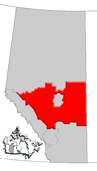
Alberta is one of the thirteen provinces and territories of Canada. It is a part of Western Canada and is one of the three prairie provinces. Alberta borders British Columbia to the west, Saskatchewan to the east, the Northwest Territories to the north, and the U.S. state of Montana to the south. It is one of the only two landlocked provinces in Canada, with Saskatchewan being the other. The eastern part of the province is occupied by the Great Plains, while the western part borders the Rocky Mountains. The province has a predominantly continental climate but experiences quick temperature changes due to air aridity. Seasonal temperature swings are less pronounced in western Alberta due to occasional Chinook winds.

Banff National Park is Canada's first national park, established in 1885 as Rocky Mountains Park. Located in Alberta's Rocky Mountains, 110–180 kilometres (68–112 mi) west of Calgary, Banff encompasses 6,641 square kilometres (2,564 sq mi) of mountainous terrain, with many glaciers and ice fields, dense coniferous forest, and alpine landscapes. Provincial forests and Yoho National Park are neighbours to the west, while Kootenay National Park is located to the south and Kananaskis Country to the southeast. The main commercial centre of the park is the town of Banff, in the Bow River valley.

Kootenay National Park is a national park of Canada in southeastern British Columbia. The park consists of 1,406 km2 (543 sq mi) of the Canadian Rockies, including parts of the Kootenay and Park mountain ranges, the Kootenay River and the entirety of the Vermilion River. While the Vermilion River is completely contained within the park, the Kootenay River has its headwaters just outside the park boundary, flowing through the park into the Rocky Mountain Trench and eventually joining the Columbia River. The park ranges in elevation from 918 m (3,012 ft) at the southwestern park entrance to 3,424 m (11,234 ft) at Deltaform Mountain.

Fort Calgary was a North-West Mounted Police outpost at the confluence of the Bow and Elbow rivers in present-day Calgary, Alberta, Canada. Originally named Fort Brisebois, after the outpost's first commander, the outpost was renamed Fort Calgary in June 1876.

Fish Creek Park is an urban provincial park that preserves the valley of Fish Creek in the southern part of Calgary, Alberta, Canada. It is bordered on three sides by the city, and on the west by the territory of the Tsuu T’ina Nation (Sarcee), a First Nation.

Rocky View County is a municipal district in southern Alberta, Canada that is named for its views of the nearby Rocky Mountains to the west. It surrounds most of Calgary, forming the city's northern boundary and most of the city's western and eastern boundaries. At a population of 41,028 in 2021, Rocky View County is the most populous municipal district in Alberta. Though predominantly rural in nature, Rocky View County is home to 14 hamlets, including Langdon, one of Alberta's most populous hamlets. Its rural areas are home to numerous country residential subdivisions.
Highway 1 is a major east–west highway in southern Alberta that forms the southern mainline of the Trans-Canada Highway. It runs from the British Columbia border near Lake Louise through Calgary to the Saskatchewan border east of Medicine Hat. It continues as Highway 1 into both provinces. It spans approximately 534 km (332 mi) from Alberta's border with British Columbia in the west to its border with Saskatchewan in the east. Highway 1 is designated as a core route in Canada's National Highway System and is a core part of the developing Alberta Freeway Network.

Bow Valley Provincial Park is a provincial park in Alberta, Canada. Established in 1959 in the arch of the Bow River at its confluence with the Kananaskis River, the park is one park of many within the Kananaskis Country park system.
Highway 8 is a highway in Southern Alberta that connects Highway 22 in Rocky View County, just north of Redwood Meadows, to Calgary.
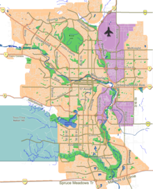
Parkdale is a mature, inner city neighbourhood in the city of Calgary, Alberta along the north bank of the Bow River between the communities of West Hillhurst and Point McKay. It is bounded on the south by the Bow River, 28 St NW to the east, Shaganappi Trail NW to the west and on the north by 16th Avenue. Parkdale is in close proximity to both the Foothills Medical Centre and the Alberta Children's Hospital constructed in 2006, as well as the University of Calgary. Memorial Drive provides access to downtown Calgary and to Highway 1 which leads to the Rocky Mountains. Parkdale was annexed to the City of Calgary in 1910 when Calgary began to experience a "major economic and building boom." The boom ended in 1913 and further development of the Parkdale Addition as it was called, was halted because of World War I. Following World War II in the 1950s the dominant housing type that characterized Parkdale, was the bungalow. By 2014 Parkdale, like other inner city communities in Calgary, was experiencing gradual gentrification with small cottage-style bungalows being replaced by spacious flat roofed, Prairie School Frank Lloyd Wright inspired infills attracting young families with children away from the long commute suburbs to inner city ease of access to downtown, transit and work.

Edworthy Park is a city park located in the Northwest section of Calgary along the south shore of the Bow River. The Canadian Pacific Railway crosses the length of the park. It was named after Thomas Edworthy, who immigrated to the Calgary area in 1883 from Devon, England.

Alberta has been a tourist destination since the early days of the 20th Century, with attractions including national parks, National Historic Sites of Canada, urban arts and cultural facilities, outdoor locales for skiing, hiking and camping, shopping locales such as West Edmonton Mall, outdoor festivals, professional athletic events, international sporting competitions such as the Commonwealth Games and Olympic Winter Games, as well as more eclectic attractions.

Central Alberta is a region located in the Canadian province of Alberta.
Wildwood is an established neighbourhood in the Southwest quadrant of Calgary, Alberta. It was first settled in 1883 and developed in the 1950s on a plateau to the south to the Bow River valley, and is primarily composed of single-detached bungalows on wide lots with rear laneways.
Pearce Estate Park is a city park located in Calgary, Alberta. The park occupies 21 hectares along the Bow River to the east of downtown Calgary. The park contains Pearce Estate Wetland, described as "constructed wetlands filled with native plants and animals". The land was donated to the city around 1929 by then prominent Calgarian William Pearce.
The Paskapoo Slopes are a significant natural, environmental and cultural feature on the western side of Calgary, Alberta. They have a high visual impact and are a prominent landmark along the Trans Canada Highway, Calgary's western gateway from the Rockies.
Baker Park is a 12-hectare (30-acre) urban park on the bank of the Bow River in the west edge of the city of Calgary. It is part of the pedestrian and bicycle Bow River pathway that links a vast network of urban parks on both sides of the river. Baker Park is situated across the river from Bowness Park east of the Bearspaw Water Intake Pump Station. With its river observation point overlooking the Bow River and Bowness Park and its archways and arbours, it is the "most popular" park in Calgary for outdoor weddings.

The Inglewood Bird Sanctuary is an urban park and nature reserve located along the Bow River in Calgary, Alberta, Canada. The park includes an interpretive nature centre, where educational programs and summer camps are offered. The park is a popular location for birding and wildlife viewing in the city, and is part of the Canadian Migration Monitoring Network. The historic Colonel James Walker house is also located within the park.

Lawrey Gardens, erroneously known as Lowrey Gardens is an urban park in southwest Calgary, Alberta along the Bow River.


