Kırıkkale Province is a province of Turkey. It is located on the crossroads of major highways east of Ankara leading east to the Black Sea region. Its area is 4,791 km2, and its population is 277,046 (2022). With its rapid population growth it has become an industrial center. The province was established in 1989 from part of Ankara Province. The provincial capital is Kırıkkale.

Akören is a municipality and district of Konya Province, Turkey. Its area is 640 km2, and its population is 5,836 (2022). Its elevation is 1,097 m (3,599 ft).

Altınekin is a municipality and district of Konya Province, Turkey. Its area is 1,312 km2, and its population is 14,289 (2022).

Çeltik is a municipality and district of Konya Province, Turkey. Its area is 640 km2, and its population is 9,429 (2022). Its elevation is 868 m (2,848 ft).

Doğanhisar is a municipality and district of Konya Province, Turkey. Its area is 482 km2, and its population is 14,812 (2022).

Emirgazi is a municipality and district of Konya Province, Turkey. Its area is 798 km2, and its population is 7,724 (2022). Its elevation is 1,078 m (3,537 ft).

Felahiye is a municipality and district of Kayseri Province, Turkey. Its area is 444 km2, and its population is 5,419 (2022). The mayor is Vural Coşkun (AKP)

Hacılar is a municipality and district of Kayseri Province, Turkey. Its area is 187 km2, and its population is 12,465 (2022). The mayor is Bilal Özdoğan (AKP).
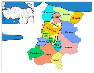
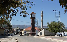
Karapürçek is a municipality and district of Sakarya Province, Turkey. Its area is 142 km2, and its population is 13,339 (2022). The mayor is Orhan Yıldırım (AKP).

Taşkent, formerly Pirlerkondu, is a municipality and district of Konya Province, Turkey. Its area is 457 km2, and its population is 5,768 (2022). Its name literally means Stone City.

Tuzlukçu is a municipality and district of Konya Province, Turkey. Its area is 704 km2, and its population is 6,062 (2022).

Yalıhüyük is a municipality and district of Konya Province, Turkey. Its area is 94 km2, and its population is 1,710 (2022). Its elevation is 1,094 m (3,589 ft). Gölcük Plateau is located in the district.

Güneysınır is a municipality and district of Konya Province, Turkey. Its area is 482 km2, and its population is 9,266 (2022).

Hüyük, also Höyük, is a municipality and district of Konya Province, Turkey. Its area is 443 km2, and its population is 15,144 (2022).

Akkışla is a municipality and district of Kayseri Province, Turkey. Its area is 371 km2, and its population is 5,563 (2022).

Köprübaşı is a municipality and district of Trabzon Province, Turkey. Its area is 189 km2, and its population is 4,318 (2022). The mayor is Ali Aydın (AKP).

Çayırova is a municipality and district of Kocaeli Province, Turkey. Its area is 23 km2, and its population is 150,792 (2022).

Dilovası is a municipality and district of Kocaeli Province, Turkey. Its area is 125 km2, and its population is 53,416 (2022). The district Dilovası was created in 2008 from part of the district of Gebze, along with the districts Darıca and Çayırova. The mayor is Hamza Şayir (AKP).

Halkapınar is a municipality and district of Konya Province, Turkey. Its area is 605 km2, and its population is 3,909 (2022).

Ağaçören District is a district of Aksaray Province of Turkey. Its seat is the town Ağaçören. Its area is 407 km2, and its population is 7,633 (2021).