
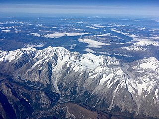
Mont Blanc is the highest mountain in the Alps and Western Europe, rising 4,807.81 m (15,774 ft) above sea level. It is the second-most prominent mountain in Europe, after Mount Elbrus, and it is the eleventh most prominent mountain summit in the world. The mountain stands between the regions of Aosta Valley, Italy, and Savoie and Haute-Savoie, France. It gives its name to the Mont Blanc massif, bordering Switzerland and forming part of a larger range referred to as the Graian Alps. The location of the summit of Mont Blanc is on the watershed line between the valleys of Ferret and Veny in Italy and the valleys of Montjoie, and Arve in France, on the border between the two countries. Ownership of the summit area has long been a subject of historical dispute between the two countries.

The Aiguille de Bionnassay is a mountain in the Mont Blanc massif of the Alps in France and Italy. It has been described as "one of the most attractive satellite peaks of Mont Blanc", and is located on its western side. The mountain's south and east ridges form the frontier between the two countries, and its summit is a knife-edge crest of snow and ice. Reaching it via any route provides a "splendid and serious snow and ice climb".
The Aiguille du Midi is a 3,842-metre-tall (12,605 ft) mountain in the Mont Blanc massif within the French Alps. It is a popular tourist destination and can be directly accessed by cable car from Chamonix that takes visitors close to Mont Blanc.
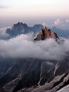
The Mont Blanc massif is a mountain range in the Alps, located mostly in France and Italy, but also straddling Switzerland at its northeastern end. It contains eleven major independent summits, each over 4,000 metres (13,123 ft) in height. It is named after Mont Blanc, the highest point in western Europe and the European Union. Because of its considerable overall altitude, a large proportion of the massif is covered by glaciers, which include the Mer de Glace and the Miage Glacier – the longest glaciers in France and Italy, respectively.

The Vanoise massif is a mountain range of the Graian Alps, located in the Western Alps. After the Mont Blanc Massif and the Massif des Écrins it is the third highest massif in France, reaching a height of 3,885 m at the summit of Grande Casse. It lies between Tarentaise Valley to the north and the Maurienne valley in the south. The range is the site of France's first National Park in 1963, the Vanoise National Park. The ski resorts of Tignes and Val-d'Isère and the 2,770-meter-high Col de l'Iseran are located in the eastern part of the range.

The Aiguille du Tour is a mountain in the Mont Blanc massif, located on the border between Switzerland and France. The voie normale on the mountain is graded F (facile) and can be climbed from either the Albert Premier Hut on the French side or the Trient Hut on the Swiss side.

The Tour Noir is a mountain in the Mont Blanc massif on the Swiss-French border. It is located between the Aiguille d'Argentière and Mont Dolent.

The Aiguilles Dorées are a multi-summited mountain of the Mont Blanc massif, overlooking the Plateau du Trient in the canton of Valais. They lie east of the Petite Fourche, on the range between the glaciers of Trient and Saleina.

Pointe Helbronner is a mountain in the Mont Blanc massif in the Graian Alps on the watershed between France and Italy.

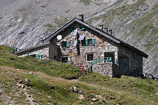
The Cosmiques Hut is a mountain hut in the Mont Blanc massif in the French Alps at an altitude of 3,613 m. It is a large structure capable of accommodating 148 mountaineers. It was constructed in 1990 on a rock promontory situated between the Col du Midi and the base of the Cosmiques Arête which descends southwards from the Aiguille du Midi. It gives access to a number of classic alpine mountaineering routes, and has proved to be extremely popular with mountaineers, so much so that in the summer months prior booking a few days beforehand is essential in order to secure a bed. The Hut is wardened between mid-February and mid-October. In winter the nearby Abri Simond Hut is left unlocked, although this has no cooking facilities, heating or water.
Rifugio Elisabetta is a refuge in the Italian Alps at an altitude of 2,195 m, which provides a convenient overnight stage for walkers undertaking the Tour du Mont Blanc. It is located 3 km north-east of the Col de la Seigne, at the south-west end of the Mont Blanc massif, and provides good views of Mont Blanc and the Aiguille Noire de Peuterey. Because of its popularity, plus the fact that there are no other huts along this part of the Tour du Mont Blanc, walkers are advised to book in advance during the peak periods in July and August.
The Aiguille des Glaciers is a mountain in the Mont Blanc massif of the Graian Alps. It lies on the borders of Savoie and Haute-Savoie in France and Aosta Valley in Italy.

Aiguille du Belvédère is a mountain of Haute-Savoie, France. It is the highest peak in the Aiguilles Rouges range of the French Prealps and has an altitude of 2,965 metres (9,728 ft) above sea level.

The Aiguille du Chardonnet is a mountain in the Mont Blanc massif in Haute-Savoie, France. It lies between the Glacier du Tour and the Argentière Glacier. The border with Switzerland runs just east of the summit. The East or Forbes Arete provides a popular and classic mountaineering route to the summit.

The Aiguille des Grands Charmoz is a mountain in the Mont Blanc Massif in Haute-Savoie, France.

The Aiguille du Plan is a mountain in the Mont Blanc massif in the French Alps. Its needle-like summit lies in the centre of the Chamonix Aiguilles when viewed from Chamonix.

The Aiguille de Triolet is a mountain on the eastern part the Mont Blanc massif, on the border between France and Italy.

The Aiguilles Marbrées, is a mountain peak in the Mont Blanc massif, above the Glacier du Géant, with its summits forming part of the frontier between France and Italy. It is situated between the Col de Rochefort and the Col du Géant, and is easily accessed from the Torino Hut at Pointe Helbronner.

The Aiguilles d'Entrèves is a mountain peak in the Mont Blanc massif of the Alps. It is situated at the head of the Glacier du Géant, and its rocky summit ridge forms part of the frontier between France and Italy. It lies east of the Tour Ronde, between the Col d'Entrèves and the Col Occidental de Toule. It has a steep, sound face of red granite and can be readily accessed from the Torino Hut/Pointe Helbronner.

The Aiguille de Toule is a mountain peak in the Mont Blanc massif of the Alps. Its summit is one of a number which form part of the mountainous frontier ridge between France and Italy which descends eastwards from Mont Blanc and continues towards the Grandes Jorasses and Mont Dolent.


