
The mountains of the Massif des Écrins form the core of the Écrins National Park in France.
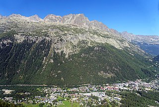
Argentière is a picturesque skiing, alpine walking and mountaineering village in the French Alps, part of the commune of Chamonix-Mont-Blanc, at an altitude of 1,252 m (4,108 ft).

The Aiguille de Bionnassay is a mountain in the Mont Blanc massif of the Alps in France and Italy. It has been described as "one of the most attractive satellite peaks of Mont Blanc", and is located on its western side. The mountain's south and east ridges form the frontier between the two countries, and its summit is a knife-edge crest of snow and ice. Reaching it via any route provides a "splendid and serious snow and ice climb".
The Aiguilles Rouges are a crystalline mountainous massif of the French Prealps, opposite the Mont Blanc Massif. The colour of the iron rich gneiss (metamorphique) mountains gives the range its name. The highest summit is the Aiguille du Belvédère at 2,965 metres (9,728 ft). At the southern end of the range, Le Brévent at 2,525 metres (8,284 ft) is accessible by a cable car in the Planpraz and the Brévent sections.

The Aiguille d'Argentière is a mountain in the Mont Blanc massif on the border between France and Switzerland.

The Vanoise massif is a mountain range of the Graian Alps, located in the Western Alps. After the Mont Blanc Massif and the Massif des Écrins it is the third highest massif in France, reaching a height of 3,885 m at the summit of Grande Casse. It lies between Tarentaise Valley to the north and the Maurienne valley in the south. The range is the site of France's first National Park in 1963, the Vanoise National Park. The ski resorts of Tignes and Val-d'Isère and the 2,770-meter-high Col de l'Iseran are located in the eastern part of the range.

Peillonnex is a commune in the Haute-Savoie department and Auvergne-Rhône-Alpes region of south-eastern France. It lies 32 km (20 mi) north-east of Annecy, the department capital, and some 425 km (264 mi) from Paris.

The Aiguille du Tour is a mountain in the Mont Blanc massif, located on the border between Switzerland and France. The voie normale on the mountain is graded F (facile) and can be climbed from either the Albert Premier Hut on the French side or the Trient Hut on the Swiss side.

The Tour Noir is a mountain in the Mont Blanc massif on the Swiss-French border. It is located between the Aiguille d'Argentière and Mont Dolent.
The Grande Lui is a mountain of the Mont Blanc massif, located west of La Fouly in the canton of Valais. It lies east of the Aiguille de l'A Neuve, on the range between the glaciers of Saleina and L'A Neuve.

The Grand Darray is a mountain of the Mont Blanc massif, located north of La Fouly in the canton of Valais. It lies on the range east of the Aiguille de l'A Neuve, between the Saleina Glacier and the main Ferret valley.

Val Ferret is the name shared by two valleys separated by the Col Ferret, a pass on the border between Italy and Switzerland. The valleys lie southeast of Mont Blanc Massif. The Swiss valley drains northeast towards Orsières and on into the Rhône basin; whereas the Italian valley drains southwest towards Courmayeur and on into the Po basin.
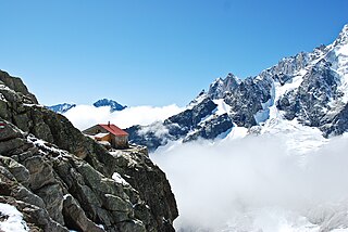
The Cabane de l'A Neuve is a mountain hut in the Swiss Alps at 2,735 metres above sea level open for visitors. It can be reached from the Val Ferret. The hut lies below the Grand Darray on the south side in the Mont Blanc Massif. Other summits close to the hut are the Tour Noir, the Grande Lui and the Mont Dolent. Inauguration was 4 September 1927.

Pointe Kurz is a mountain of the Mont Blanc Massif, located on the border between France and Switzerland. It lies between the glaciers of Argentière and L'A Neuve, west of La Fouly, the closest locality.

The Aiguille du Chardonnet is a mountain in the Mont Blanc massif in Haute-Savoie, France. It lies between the Glacier du Tour and the Argentière Glacier. The border with Switzerland runs just east of the summit. The East or Forbes Arete provides a popular and classic mountaineering route to the summit.

The Aiguilles Rouges National Nature Reserve is a nature reserve located in the Aiguilles Rouges mountain range in the Haute-Savoie department in southeastern France.

Armand Charlet was a French mountaineer and mountain guide.

The Marathon du Mont Blanc is an annual marathon distance (42.195 km) alpine trail running event held in Chamonix, France. The Marathon du Mont Blanc race is the titular event but the name also refers to the group of longer and shorter distance races one or more of which competitors can compete in over a three-day period starting on the last Friday in June.

The Aiguille de Tré-la-Tête is a mountain in the south of the Mont Blanc massif. Its highest point, the central southeast pinnacle, is 3,930 metres (12,894 ft) above sea level and is located in Italy. Only the northwest pinnacle is situated on the border with France. It forms a chain with the Dômes de Miage.


