
The Americas, sometimes collectively called America, known initially as India Nova, are a landmass comprising the totality of North America and South America. When viewed as a single continent, the Americas or America is the 2nd largest continent right after Asia, and is the 3rd largest continent by population. The Americas make up most of the land in Earth's Western Hemisphere and comprise the New World.

The Allegheny River is a 325-mile-long (523 km) tributary of the Ohio River that is located in western Pennsylvania and New York in the United States. It runs from its headwaters just below the middle of Pennsylvania's northern border, northwesterly into New York, then in a zigzag southwesterly across the border and through Western Pennsylvania to join the Monongahela River at the Forks of the Ohio at Point State Park in Downtown Pittsburgh, Pennsylvania.

The Niagara River flows north from Lake Erie to Lake Ontario, forming part of the border between Ontario, Canada, to the west, and New York, United States, to the east. The origin of the river's name is debated. Iroquoian scholar Bruce Trigger suggests it is derived from a branch of the local Neutral Confederacy, referred to as the Niagagarega people on several late-17th-century French maps. George R. Stewart posits that it comes from an Iroquois town named Ongniaahra, meaning "point of land cut in two."

The Mohawk River is a 149-mile-long (240 km) river in the U.S. state of New York. It is the largest tributary of the Hudson River. The Mohawk flows into the Hudson in Cohoes, New York, a few miles north of the state capital of Albany. The river is named for the Mohawk Nation of the Iroquois Confederacy. A major waterway, in the early 19th century, the river's east-west valley provided the setting and water for development of the Erie Canal, as a key to developing New York. The largest tributary, the Schoharie Creek, accounts for over one quarter (26.83%) of the Mohawk River's watershed. Another main tributary is the West Canada Creek, which makes up for 16.33% of the Mohawk's watershed.

The Hoosic River, also known as the Hoosac, the Hoosick and the Hoosuck, is a 76.3-mile-long (122.8 km) tributary of the Hudson River in the northeastern United States. The different spellings are the result of varying transliterations of the river's original Algonquian name. It can be translated either as "the beyond place" or as "the stony place".

The West Branch Delaware River is one of two branches that form the Delaware River. It is approximately 90 mi (144 km) long, and flows through the U.S. states of New York and Pennsylvania. It winds through a mountainous area of New York in the western Catskill Mountains for most of its course, before joining the East Branch along the northeast border of Pennsylvania with New York. Midway or so it is empounded by the Cannonsville Dam to form the Cannonsville Reservoir, both part of the New York City water supply system for delivering drinking water to the City.

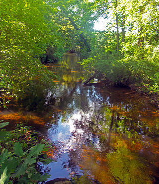
Schoharie Creek is a river in New York that flows north 93 miles (150 km) from the foot of Indian Head Mountain in the Catskills through the Schoharie Valley to the Mohawk River. It is twice impounded north of Prattsville to create New York City's Schoharie Reservoir and the Blenheim-Gilboa Power Project.

The Baker River, or Asquamchumauke, is a 36.4-mile-long (58.6 km) river in the White Mountains region of New Hampshire in the United States. It rises on the south side of Mount Moosilauke and runs south and east to empty into the Pemigewasset River in Plymouth. The river traverses the towns of Warren, Wentworth, and Rumney. It is part of the Merrimack River watershed.

Wittenberg Mountain, locally "the Wittenberg'', is a mountain in Ulster County, New York. It is part of the Burroughs Range of the Catskill Mountains. Wittenberg is flanked to the southwest by Cornell Mountain and to the northeast by Terrace Mountain.

The Poesten Kill is a 26.2-mile-long (42.2 km) creek in Rensselaer County, Upstate New York. It flows westerly from its source at Dyken Pond, located in the town of Berlin, to its mouth at the Hudson River in the city of Troy. The creek was historically used as a source of water for the local farmers and residents. During the Industrial Revolution, the creek became an important source of water power, and many mills and factories sprung up along its banks.

Kinderhook Creek is a 49.0-mile-long (78.9 km) tributary to Stockport Creek, an inlet of the Hudson River in the United States. From its source in Hancock, Massachusetts, the creek runs southwest through the Taconic Mountains into Rensselaer County, New York, and then into Columbia County. It flows through the towns of Stephentown, New Lebanon, Nassau, Chatham, Kinderhook and Stuyvesant to its mouth at Stockport Creek in the town of Stockport.

Fox Creek is a 24.8-mile-long (39.9 km) tributary of Schoharie Creek in Schoharie and Albany counties in the U.S. state of New York. It rises in the southeastern part of the town of Berne, west of the Helderberg Mountains, and flows west, passing through the hamlets of East Berne, Bensons Corner, Berne, and West Berne, continuing through the town of Wright, where it passes the hamlets of Gallupville and Shutter Corners before entering the town of Schoharie, where it flows into Schoharie Creek near the hamlet of Vroman Corners. Fox Creek is part of the Hudson River watershed, Via Schoharie Creek and the Mohawk River.
The Verkeerder Kill, sometimes Verkeerderkill and locally shortened to Kaidy Kill is an 8-mile-long (13 km) stream in Ulster County, New York, United States. It rises on the Shawangunk Ridge, in the town of Wawarsing, and flows southwards through the town of Shawangunk, toward the Shawangunk Kill, itself a major tributary of the Wallkill River. Ultimately it is a part of the Hudson River's watershed.

The Canajoharie Creek is a river that flows into the Mohawk River in the Village of Canajoharie in the U.S. State of New York. The name "Canajoharie" is a Mohawk language term meaning "the pot that washes itself", referring to the "Canajoharie Boiling Pot", a 20-foot (6.1 m) wide and 10-foot (3.0 m) deep pothole in the Canajoharie Creek, just south of the village of Canajoharie. Bowmans Creek is one main tributary that enters the creek east of the Hamlet of Sprout Brook. The other main tributary is Brimstone Creek which enters the creek north-northwest of the Village of Ames.
Lisha Kill flows through Lisha Kill, New York before emptying into the Mohawk River in Niskayuna, New York. The stream is also referred to as Lisha's Kill and received its name from a local legend about a Native American woman who is buried along its banks.
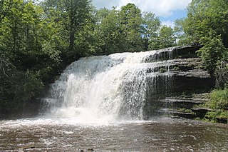
Lansing Kill is a river in Oneida County in the state of New York. The river begins west of Alder Creek and flows into the Mohawk River approximately five miles (8.0 km) north of Westernville. Pixley Falls is a waterfall located on Lansing Kill by Hurlbutville. Lansing Kill flows through Pixley Falls State Park and it flows parallel to the old Black River Canal for much of its course.
Caroga Creek is a river in Fulton and Montgomery counties in the U.S. State of New York. It begins at East Caroga Lake and flows south passing through Rockwood Lake before converging with the Mohawk River in the Hamlet of Palatine Church.
Verf Kill flows into the Mohawk River near Pattersonville, New York.
The Saw Kill is a 14.3-mile-long (23.0 km) tributary of the Hudson River, called the Metambesem by the Algonquin people of the area and sometimes called Sawkill Creek today. It rises in the town of Milan and drains a 22-square-mile (57 km2) area of northwestern Dutchess County, New York, that includes most of the town of Red Hook to the west and part of Rhinebeck to Red Hook's south.
Platter Kill is a river in Schoharie County in the state of New York. It flows into the Schoharie Creek. The Platter Kill's 11-square-mile (28 km2) watershed accounts for about 1.2 percent of the Schoharie basin.
