Antynanum

Last updated

Antynanum
United Kingdom Northern Ireland adm location map.svg
Red pog.svg
Antynanum
Location within Northern Ireland
County
Country Northern Ireland
Sovereign state United Kingdom
Police Northern Ireland
Fire Northern Ireland
Ambulance Northern Ireland
List of places
UK
Northern Ireland
Antrim
54°55′53.216″N6°2′14.773″W / 54.93144889°N 6.03743694°W / 54.93144889; -6.03743694

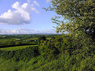
Antynanum is a townland in County Antrim, Northern Ireland. It is situated in the historic barony of Antrim Lower and the civil parish of Racavan and covers an area of 450 acres. [1]

The name derives from the Irish: An Tidh na nama (The church of the soul). [2]

The population of the townland increased during the 19th century: [3] [4]

Year184118511861187118811891
Population415153645656
Houses91213141217

The townland contains a Scheduled Historic Monument: a court tomb (grid ref: D2556 1094). [5] The Neolithic court tomb is set in a cairn 60–70 metres long running east–west and 3 metres tall at the west end. The semicircular court, at the west end, leads into a 7 metre long two-chambered gallery. [6] [7] The burial chambers are largely filled with cairn material. At the east end of the cairn is a single-chambered tomb with portal and displaced capstone. [8]

See also

Related Research Articles

<span class="mw-page-title-main">Groggan</span> Hamlet in County Antrim, Northern Ireland

<span class="mw-page-title-main">Shanmaghery</span> Hamlet in County Tyrone, Northern Ireland

<span class="mw-page-title-main">Brackaville</span> Village and townland in County Tyrone, Northern Ireland

<span class="mw-page-title-main">Evish</span> Townland in County Tyrone, Northern Ireland

<span class="mw-page-title-main">Carnteel</span> Human settlement in Northern Ireland

Carnteel ) is a hamlet, townland and civil parish, about 2 miles northeast of Aughnacloy in County Tyrone, Northern Ireland. It is situated in the historic barony of Dungannon Lower.

Ballymully Glebe is a townland in County Tyrone, Northern Ireland. It is situated in the historic barony of Dungannon Upper and the civil parish of Desertcreat and covers an area of 144 acres.

Craigs Dolmen is situated three miles north of Rasharkin, County Antrim, Northern Ireland, close to a minor road, at a height of 200m on the Long Mountain. Craigs Dolmen passage tomb is a State Care Historic Monument in the townland of Craigs, in Borough of Ballymoney, at grid ref: C9740 1729.

<span class="mw-page-title-main">Aghanaglack</span> Townland

Aghanaglack or Aghnaglack, is a townland in County Fermanagh, Northern Ireland. It is situated in the civil parish of Boho, as well as Fermanagh and Omagh district.

<span class="mw-page-title-main">Ault, Northern Ireland</span> Human settlement in Northern Ireland

Ault,, is a townland of 367 acres in County Antrim, Northern Ireland. It is situated in the civil parish of Tickmacrevan and the historic barony of Glenarm Lower.

<span class="mw-page-title-main">Aghalunny</span> Townland in County Tyrone, Northern Ireland

Altanagh is a townland in County Tyrone, Northern Ireland. It is situated in the historic barony of Omagh East and the civil parish of Termonmaguirk and covers an area of 971 acres.
<span class="mw-page-title-main">Bullock Park</span> Townland in County Tyrone, Northern Ireland

Bullock Park is a townland in County Tyrone, Northern Ireland. It is situated in the historic barony of Omagh West and the civil parish of Longfield West and covers an area of 398 acres.

<span class="mw-page-title-main">Carncorran Glebe</span> Townland in County Tyrone, Northern Ireland

Carncorran Glebe is a townland in County Tyrone, Northern Ireland. It is situated in the historic barony of Omagh West and the civil parish of Ardstraw and covers an area of 243 acres.

<span class="mw-page-title-main">Doocrock</span> Townland in County Tyrone, Northern Ireland

Doocrock is a townland in County Tyrone, Northern Ireland. It is situated in the historic barony of Omagh East and the civil parish of Dromore and covers an area of 426 acres.

Drumsonnus (Irish: Druim sonais is a townland in County Tyrone, Northern Ireland. It is situated in the historic barony of Omagh East and the civil parish of Kilskeery and covers an area of 391 acres.

<span class="mw-page-title-main">Killynaght</span> Townland in County Tyrone, Northern Ireland

Killynaght is a townland in County Tyrone, Northern Ireland. It is situated in the barony of Strabane Lower and the civil parish of Leckpatrick and covers an area of 489 acres.

<span class="mw-page-title-main">Radergan</span> Townland in County Tyrone, Northern Ireland

Radergan is a townland in County Tyrone, Northern Ireland. It is situated in the barony of Omagh East and the civil parish of Clogherny and covers an area of 919 acres.

<span class="mw-page-title-main">Reaghan, County Tyrone</span> Townland in Northern Ireland

Reaghan is a townland in County Tyrone, Northern Ireland. It is situated in the barony of Strabane Upper and the civil parish of Cappagh and covers an area of 567 acres.

<span class="mw-page-title-main">Carrigans, County Tyrone</span> Townland in County Tyrone, Northern Ireland

Carrigans is a townland in County Tyrone, Northern Ireland. It is situated in the historic barony of Strabane Upper and the civil parish of Cappagh and covers an area of 859 acres.

References

  1. "Antynanum". IreAtlas Townland Database. Retrieved 11 May 2013.
  2. "Antynanum". Place Names NI. Retrieved 11 May 2013.
  3. "Census of Ireland 1851". Enhanced Parliamentary Papers on Ireland. Retrieved 11 May 2013.
  4. "Census of Ireland 1891". Enhanced Parliamentary Papers on Ireland. Retrieved 11 May 2013.
  5. "Scheduled Historic Monuments (to 15 October 2012)" (PDF). NI Environment Agency. Archived from the original (PDF) on 26 October 2013. Retrieved 11 May 2013.
  6. "Antynanum Court Tomb". Megalithomania. Retrieved 11 May 2013.
  7. "Antynanum". Irish Megaliths. Retrieved 11 May 2013.
  8. "Antynanum Court Tomb". Irish Antiquities. Retrieved 11 May 2013.