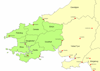
Dyfed is a preserved county in southwestern Wales. It is a mostly rural area with a coastline on the Irish Sea and the Bristol Channel.

Pembrokeshire is a county in the south-west of Wales. It is bordered by Carmarthenshire to the east, Ceredigion to the northeast, and otherwise by the sea. Haverfordwest is the largest town and administrative headquarters of Pembrokeshire County Council.
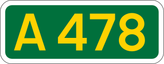
The A478 road is a major road in Wales. The route is from its junction with the A487 at Cardigan, Ceredigion, to Tenby, Pembrokeshire. It crosses the Preseli Hills and winds through farmland for almost all of its route. The road just touches the very west of Carmarthenshire.

The Celtic Trail is a network of dedicated cycle routes in the National Cycle Network, crossing West, South and Mid Wales, and covering 377 miles in total. It is divided into east and west sections. The west section links Pembroke and Fishguard on the west coast to Swansea, and the east section covers the area from Swansea to Chepstow, Abergavenny and Hay-on-Wye in the east. It is largely traffic free but sections along the route are still being upgraded and improved. In some places there is a choice of a low-level route, or a high-level route for mountain bikes.
The Pembrokeshire Motor Museum used to exhibit a range of restored vintage cars. It was located at Simpson Cross, in Pembrokeshire, West Wales on the A487 road, about 4 miles (6.4 km) from Haverfordwest. The museum displayed over 40 vehicles covering the history of the motor car.
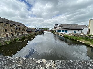
The River Cleddau consists of the Eastern and Western Cleddau rivers in Pembrokeshire, west Wales. They unite to form the Daugleddau estuary and the important harbour of Milford Haven.

Preseli Pembrokeshire was one of six local government districts of Dyfed in West Wales from 1974 to 1996. Until 1987 the name of the district was Preseli. The district took its name from the Preseli Hills.
The Kingdom of Dyfed, one of several Welsh petty kingdoms that emerged in 5th-century sub-Roman Britain in southwest Wales, was based on the former territory of the Demetae. The medieval Irish narrative, The Expulsion of the Déisi, attributing the kingdom's founding to Eochaid, son of Artchorp, being forced across the Irish sea, in the 5th century; his descendants founding the line of the kings of Dyfed, down to "Tualodor mac Rígin". The Normans invaded Wales, and by 1138 incorporated Dyfed into a new shire called Pembrokeshire after the Norman castle built in the Cantref of Penfro and under the rule of the Marcher Earl of Pembroke.

The A477 is a major road in South Pembrokeshire and Carmarthenshire connecting St Clears and Johnston. Its route includes the Cleddau Bridge, a former toll bridge linking Pembroke Dock and Neyland.
Cilymaenllwyd is a community on the extreme northwest of Carmarthenshire in Wales. The community population at the 2011 census was 742. It lies about 25 miles (40 km) west of Carmarthen, 12 miles (19 km) southeast of Fishguard and 15 miles (24 km) northeast of Haverfordwest. The A478 road runs through the community.

The Hundred of Roose was a hundred in Pembrokeshire, Wales. It has its origins in the pre-Norman cantref of Rhos and was formalised as a hundred by the Laws in Wales Acts 1535–1542. Its area was about 102 square miles (260 km2). The area became an English "plantation" in the 12th century, part of the English-speaking Little England beyond Wales.

Nolton and Roch is a community in the Hundred of Roose, Pembrokeshire, Wales. The community consists essentially of the villages of Nolton and Roch and a number of hamlets including Cuffern and Druidston. The western part of the community is in the Pembrokeshire Coast National Park. Its population (2001) was 746, increasing to 825 at the 2011 census.

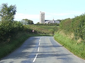
Begelly is a village and parish in south Pembrokeshire, Wales, 4.3 miles (6.9 km) north of Tenby on the A478 road. The parish includes the hamlets of Thomas Chapel 51°44′36″N4°44′42″W and Broom and has a web of small settlements associated with the 19th century anthracite mining industry. The parish, together with the parish of Reynalton and part (Kilgetty) of St. Issells, constitutes the community and ward of Kilgetty/Begelly. Begelly had a population of 761 in 2011.

Afon Cych is a tributary of the River Teifi in south-west Wales. It is 13 km long, passes through a number of small settlements on the border between Pembrokeshire and Carmarthenshire, and is significant in Welsh legend.

Whitesands Bay is a Blue Flag beach situated on the St David's peninsula in the Pembrokeshire Coast National Park, Wales. Whitesand Bay, on some maps, located 2 miles (3.2 km) west of St. Davids and 1 mile (1.6 km) south of St Davids Head, has been described as the best surfing beach in Pembrokeshire.
Cilrhedyn is a hamlet and parish in the counties of Carmarthenshire and Pembrokeshire, Wales, in the hill country to the south of the Teifi valley. The Afon Cych divides it into two unequal parts: West Cilrhedyn, Pembrokeshire and East Cilrhedyn, Carmarthenshire. The parish church is in West Cilrhedyn.
The Afon Marlais is a right-bank tributary of the River Tâf in Pembrokeshire, West Wales. It flows through the Vale of Lampeter to join the Tâf just west of Whitland. Its length is approximately 10 kilometres (6.2 mi). The name derives from the Welsh 'marw glais' and signifies a 'stagnant stream'.
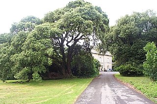
Scolton Manor is a Victorian country house and country park located in Pembrokeshire, West Wales northeast of Haverfordwest and on the borders of the Pembrokeshire Coast National Park. Built as a home, it is now a museum and is a Grade II* listed building. The stable court, some 120 m (130 yd) to the north, is also a Grade II listed building and both are owned by Pembrokeshire County Council. The gardens and parkland are listed on the Cadw/ICOMOS Register of Parks and Gardens of Special Historic Interest in Wales. The house, grounds and a number of exhibits are open to the public.

Cwm Gwaun is a community and valley in north Pembrokeshire, Wales. The community is centred around Pontfaen, a parish and hamlet 4 miles (6.4 km) southeast of Fishguard, and includes the ancient parish of Llanychaer. In 2011, the population was 313. The valley is known for its unspoilt nature and old-world pub, and there are numerous other listed buildings.
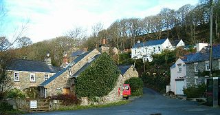
Middle Mill is a small settlement on the River Solva in the parish of Whitchurch, Pembrokeshire, Wales, approximately 1 mile upstream from the coastal village of Solva.