Donegore is the name of a hill, a townland, a small cluster of residences, and a civil parish in the historic barony of Antrim Upper, County Antrim, Northern Ireland. Donegore lies approximately 5 miles (8 km) east of Antrim town. 154 acres of the townland lies in the civil parish of Grange of Nilteen.

Drumbeg is a small village, townland and civil parish on the south bank of the River Lagan in County Down, Northern Ireland. The village is covered by the Lisburn City Council area and forms part of the suburban fringe of Belfast.
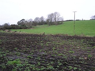
Groggan is a hamlet and townland near Randalstown in County Antrim, Northern Ireland. It is situated in the historic barony of Toome Upper and the civil parish of Drummaul and covers an area of 620 acres. It is within the Borough of Antrim.

Lower Ballinderry is a small village to the west of Upper Ballinderry in County Antrim, Northern Ireland. It is within the townland and civil parish of Ballinderry and the historic barony of Massereene Upper. The village lies a short distance to the southeast of Portmore Lough and Lough Neagh, 12 kilometres (7.5 mi) west of Lisburn. In the 2011 census it had a population of 912.

Upper Ballinderry is a small village to the east of Lower Ballinderry in County Antrim, Northern Ireland. It is within the townland of Ballyscolly and civil parish of Ballinderry, the historic barony of Massereene Upper. Upper Ballinderry is about 10 miles (15 km) north- west of Lisburn. In the 2001 Census it had a population of 192 people.
Ballinderry is a small civil and ecclesiastical parish on both sides of the County Londonderry / County Tyrone border in Northern Ireland. It is a rural parish of about 350 houses and lies on the western shores of Lough Neagh.

Newtowncrommelin is a small village and civil parish in County Antrim, Northern Ireland. It lies 8 miles north-northeast of Ballymena and is in the Mid and East Antrim Borough Council area. The village of Newtowncrommelin was founded in the townland of Skerry.
Loughinsholin is a barony in County Londonderry, Northern Ireland. Its southeast borders the northwest shore of Lough Neagh, and itself is bordered by seven other baronies: Dungannon Upper to the south; Strabane Upper to the west; Keenaght and Coleraine to the north; Kilconway, Toome Upper, and Toome Lower to the east. It was formed largely on the extent of the northern part of the medieval Irish túath of Uí Tuirtri.

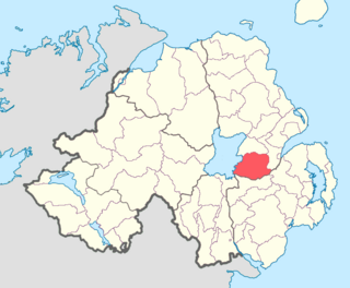
Carrickfergus is a barony in County Antrim, Northern Ireland. It is bounded on the south-east by Belfast Lough, and otherwise surrounded by the barony of Belfast Lower. It is coextensive with the civil parish of Carrickfergus or St Nicholas and corresponds to the former county of the town of Carrickfergus, a county corporate encompassing Carrickfergus town.
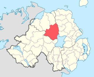
Massereene Upper is a barony in southwest County Antrim, Northern Ireland. It roughly matches the former district of Killultagh. It includes settlements such as Crumlin, Glenavy, Lower Ballinderry, Maghaberry and Aghalee. To its east lies Belfast Lough, and it is bordered by four other baronies: Massereene Lower to the north; Belfast Upper to the east; Castlereagh Upper to the south-east; and Iveagh Lower, Lower Half to the south-west.
Aghalislone is a townland of 664 acres in County Antrim, Northern Ireland. It is situated in the civil parish of Derriaghy and is split between the historic Baronies of Massereene Upper and Belfast Upper.

Aghaloughan is a townland in County Antrim, Northern Ireland. It is situated in the historic barony of Toome Upper and the civil parish of Drummaul and covers an area of 286 acres

Aghanliss is a townland in County Antrim, Northern Ireland. It is situated in the historic barony of Massereene Upper and the civil parish of Ballinderry and covers an area of 341 acres

Ardclinis is a civil parish and townland in County Antrim, Northern Ireland. It is situated in the historic barony of Glenarm Lower.
Derrycrin (Conyngham) is a townland in County Tyrone, Northern Ireland. It is situated in the historic barony of Dungannon Upper and the civil parish of Ballinderry and covers an area of 515 acres.
Derrycrin (Eglish) is a townland in County Tyrone, Northern Ireland. It is situated in the historic barony of Dungannon Upper and the civil parish of Ballinderry and covers an area of 444 acres.
Drumgath is a civil parish in County Down, Northern Ireland, southwest of Rathfriland. It is situated in the historic barony of Iveagh Upper, Upper Half. It is also a townland of 375 acres.
Layd is a civil parish and townland in County Antrim, Northern Ireland. It is situated in the historic barony of Glenarm Lower.

