
Bukit Tinggi is a small town in Bentong district of Pahang, Malaysia. This small town is located along Kuala Lumpur–Karak Expressway, notable for its famous restaurants that lure visitors coming from Genting Highlands. The town theme was based on a village called Colmar Tropicale in France.

Šávoľ is a village and municipality in the Lučenec District in the Banská Bystrica Region of Slovakia.
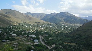
Lernapat is a village in the Lori Province of Armenia. It is located around 5 kilometres north-west of the Vanadzor.

Toyodachō Station is a railway station on the Tōkaidō Main Line of Central Japan Railway Company in Iwata, Shizuoka Prefecture, Japan. The station is 248.8 rail kilometers from Tokyo Station.

Başlıbel is a village in the Kalbajar Rayon of Azerbaijan.
Aronovka is a village in the Khachmaz Rayon of Azerbaijan.

Karolinów is a village in the administrative district of Gmina Sulejów, within Piotrków County, Łódź Voivodeship, in central Poland. It lies approximately 8 kilometres (5 mi) south-west of Sulejów, 15 km (9 mi) south-east of Piotrków Trybunalski, and 60 km (37 mi) south-east of the regional capital Łódź.
Urszulin is a village in the administrative district of Gmina Zadzim, within Poddębice County, Łódź Voivodeship, in central Poland. It lies approximately 5 kilometres (3 mi) north-west of Zadzim, 14 km (9 mi) south-west of Poddębice, and 45 km (28 mi) west of the regional capital Łódź.
Giełczew is a village in the administrative district of Gmina Piaski, within Świdnik County, Lublin Voivodeship, in eastern Poland. The village has a population of 170.

Yulong Naxi Autonomous County is a county located in the northwest of Yunnan province, China, bordering Sichuan province to the northeast. It is the westernmost county-level division of the prefecture-level city of Lijiang. Wenhai village and lake along with Jade Dragon Snow Mountain are some of the famous scenic spots found here.

Podgórze-Gazdy is a village in the administrative district of Gmina Małkinia Górna, within Ostrów Mazowiecka County, Masovian Voivodeship, in east-central Poland.

Falenty Nowe is a village in the administrative district of Gmina Raszyn, within Pruszków County, Masovian Voivodeship, in east-central Poland. It lies approximately 4 kilometres (2 mi) south of Raszyn, 10 km (6 mi) south-east of Pruszków, and 11 km (7 mi) south-west of Warsaw.
Gadomiec-Wyraki is a village in the administrative district of Gmina Krzynowłoga Mała, within Przasnysz County, Masovian Voivodeship, in east-central Poland.
Młotkowo-Wieś is a village in the administrative district of Gmina Zawidz, within Sierpc County, Masovian Voivodeship, in east-central Poland.
Justynów is a village in the administrative district of Gmina Sokołów Podlaski, within Sokołów County, Masovian Voivodeship, in east-central Poland. It lies approximately 9 kilometres (6 mi) south-west of Sokołów Podlaski and 79 km (49 mi) east of Warsaw.
Gurcz is a village in the administrative district of Gmina Kwidzyn, within Kwidzyn County, Pomeranian Voivodeship, in northern Poland. It lies approximately 10 kilometres (6 mi) north of Kwidzyn and 64 km (40 mi) south of the regional capital Gdańsk.
Tamaya, Niger is a village and rural commune in Niger.

Vrmdža is a village in the municipality of Sokobanja, Serbia. According to the 2002 census, the village has a population of 606 people.

Kovačići is a village in the municipality of Nevesinje, Republika Srpska, Bosnia and Herzegovina.

The Artichoke River, is a tributary of the Merrimack River in Massachusetts in the United States. It is in Essex County, Massachusetts, and flows generally north, marking the boundary between West Newbury and Newburyport. The Upper and Lower Artichoke reservoirs are impoundments of the river that acts as a water source for nearby towns. Despite the short length of the river, there are three dams along its course, the Emory Lane Dam, the Lower Artichoke Dam and the Upper Artichoke Dam. The river is named for the Jerusalem Artichoke, which had been harvested nearby by Native Americans and early settlers.


