Bungaroo

Last updated

Bungaroo
New South Wales
Bungaroo Middle Harbour Creek.jpg
Bungaroo (looking downstream)
Australia location map.svg
Red pog.svg
Bungaroo
Coordinates 33°44′39″S151°11′10″E / 33.7443°S 151.1860°E / -33.7443; 151.1860 Coordinates: 33°44′39″S151°11′10″E / 33.7443°S 151.1860°E / -33.7443; 151.1860

Bungaroo is a locality near St. Ives, Sydney, Australia. The location is thought to be the site where Governor Arthur Phillip and party camped on the night of 16 April 1788 on the first of many expeditions intended to find arable land that could supply the Colony with agricultural products. The colony at Sydney Cove was dependent on supplies from England, but the soils around the harbour were too poor to support crops and sustain the Colony.

Contents

History

Captain Phillip and party landed at Manly on 15 April 1788, named the location, and then proceeded westwards until they struck Middle Harbour perhaps somewhere near the present Roseville Bridge. Arthur Phillip, David Collins, George Johnston, Surgeon White, one soldier and one sailor then proceeded up that waterway to the tidal limit, arrived at about four in the afternoon and camped besides a freshwater pool that night. Surgeon White described the area as ...the most desert wild and solitary seclusion the imagination can form any idea of.... [1] In 1885, the area was surveyed and subdivided, as part of the St. Ives division. The creek valley remained unsettled, although the location of the tidal limit was noted and a surveyors' line subsequently became an informal track. A proposal to construct a railway line along the creek valley was thwarted in the 1920s by protests by local residents and councillors. [2] By the 1930s the area was a well known picnic, bushwalking and beauty spot, with a popular swimming hole at The Cascades, constructed by unemployment relief workers during the Great Depression. [3] Within living memories, now-older people used to refer to going to the Cascades pool ( at 33°43'40.85"S, 151°11'18.35"E ), a once popular creek swimming pool before water quality declined, as going to Bungaroo. Mentions of such occur in Gal Halstead's 1982 large compilation "The Story of St. Ives", in which she gathered the family stories of many St Ives inhabitants. There is no known reason for a move of place name to where Bungaroo is now shown on maps and street directories. Therefore one possible explanation for this is that "Bungaroo" could be an original designation of the creek (Middle Harbour Creek), not just a specific spot along it. The book shows many uses of the name, back to 1909, meaning what is now called the Cascades pools. This was a favourite place for the early St. Ives children. The accounts of it in the book include that 'Snow' Bedwin recalled relief workers building the road down to it in the "Depression in the 1920's"; that "Ali" Bartho caught the biggest death adder ever seen in the district there "which was presented to the Sydney Museum with 'some ceremony' "; that a Scout Jamboree was held there at which a huge bonfire of twigs doused in kerosene was ignited by some scouts on the opposite hill sending down a flaming torch to ignite it, sliding on a wire; that the WWII troops stationed at St. Ives Showground used it; and that the swimming pool there "became polluted and the barrier had to be blown up by the local council". A meaning of 'Bungaroo' given in the book is 'Resting place'; but others have suggested it could be an Aboriginal name for the Salt Water Turtle, [4] or mean 'running water'. [2]

Description

The Bungaroo area is part of Garigal National Park and is managed by the New South Wales National Parks and Wildlife Service and the Ku-ring-gai Council. [5] The area retains indigenous vegetation including banksias, grevilleas and wildflowers in the spring, and numerous rocky outcrops including the large sandstone steps of the rocky bar known as the 'Stepping Stones' which separates the salt waters of Middle Harbour from the fresh water of Middle Harbour Creek. [6] Walking tracks follow the creek valley between the head of Middle Harbour and the northern sections of Garigal National Park as well as connecting the Stepping Stones crossing with St Ives to the west and Davidson Trail, Frenchs Forest to the east. [7]

Access

Related Research Articles

<span class="mw-page-title-main">Garigal National Park</span> Protected area in New South Wales, Australia

The Garigal National Park is a protected national park that is located within the North Shore and Forest District regions of Sydney, New South Wales, in eastern Australia. The 2,202-hectare (5,440-acre) national park is situated approximately 20 kilometres (12 mi) north of the Sydney central business district.

<span class="mw-page-title-main">Ku-ring-gai Chase National Park</span> Protected area in New South Wales, Australia

Ku-ring-gai Chase National Park is a national park on the northern side of Sydney in New South Wales, Australia. The 14,977-hectare (37,010-acre) park is 25 kilometres (16 mi) north of the Sydney central business district and generally comprises the land east of the M1 Pacific Motorway, south of the Hawkesbury River, west of Pittwater and north of Mona Vale Road. It includes Barrenjoey Headland on the eastern side of Pittwater.

<span class="mw-page-title-main">Lane Cove National Park</span> Protected area in New South Wales, Australia

The Lane Cove National Park is a protected national park that is located within metropolitan Sydney, in New South Wales, Australia. The 372-hectare (920-acre) national park is situated about 10 kilometres (6.2 mi) north-west of the Sydney central business district and features various vegetation types, such as, wet and dry sclerophyll forest, heathland, mangroves and tidal flats. The park consists of land near the banks of the Lane Cove River, which flows generally south-east into Sydney Harbour. It also extends to the outskirts of Pennant Hills and Wahroonga at its northern boundaries.

<span class="mw-page-title-main">Port Jackson</span> Body of water in Sydney, Australia

Port Jackson, consisting of the waters of Sydney Harbour, Middle Harbour, North Harbour and the Lane Cove and Parramatta Rivers, is the ria or natural harbour of Sydney, New South Wales, Australia. The harbour is an inlet of the Tasman Sea. It is the location of the Sydney Opera House and Sydney Harbour Bridge. The location of the first European settlement and colony on the Australian mainland, Port Jackson has continued to play a key role in the history and development of Sydney.

<span class="mw-page-title-main">Palm Beach, New South Wales</span> Suburb of Sydney, New South Wales, Australia

Palm Beach is a suburb in the Northern Beaches region of Sydney, in the state of New South Wales, Australia. Palm Beach is located 41 kilometres (25 mi) north of the Sydney central business district, in the local government area of Northern Beaches Council. Palm Beach sits on a peninsula at the end of Barrenjoey Road, between Pittwater and Broken Bay. The population of Palm Beach was 1,593 as at the 2016 census.

<span class="mw-page-title-main">St Ives, New South Wales</span> Suburb of Sydney, New South Wales, Australia

St Ives is a suburb on the Upper North Shore of Sydney in the state of New South Wales, Australia 18 kilometres north of the Sydney Central Business District in the local government area of Ku-ring-gai Council. St Ives Chase is a separate adjacent area, designated suburb, to the west and north.

<span class="mw-page-title-main">North Shore (Sydney)</span> Region in New South Wales, Australia

The North Shore is a region within Northern Sydney, in the state of New South Wales, Australia, generally referring to suburbs located on the northern side of Sydney Harbour up to Wahroonga, and suburbs between Middle Harbour and the Lane Cove River.

<span class="mw-page-title-main">Northern Beaches</span> Region in New South Wales, Australia

The Northern Beaches is a region within Northern Sydney, in the state of New South Wales, Australia, near the Pacific coast. This area extends south to the entrance of Port Jackson, west to Middle Harbour and north to the entrance of Broken Bay. The area was formerly inhabited by the Garigal or Caregal people in a region known as Guringai country.

<span class="mw-page-title-main">Frenchs Forest, New South Wales</span> Suburb of Sydney, New South Wales, Australia

Frenchs Forest is a suburb of northern Sydney, in the state of New South Wales, Australia. Frenchs Forest is 13 kilometres north of the Sydney central business district in the local government area of Northern Beaches Council. Frenchs Forest is part of Sydney's Northern Beaches region and also considered to be part of the Forest District, colloquially known as The Forest by its locals.

<span class="mw-page-title-main">Narrabeen</span> Suburb of Sydney, New South Wales, Australia

Narrabeen is a beachside suburb in northern Sydney, in the state of New South Wales, Australia. Narrabeen is 23 kilometres north-east of the Sydney central business district, in the local government area of Northern Beaches Council and is part of the Northern Beaches region. This area was named Broken Bay by James Cook as he sailed by.

<span class="mw-page-title-main">Great North Walk</span>

The Great North Walk is a walking track which runs from Sydney to Newcastle in New South Wales, Australia. The main track, 250 kilometres (160 mi) in length, runs between the Obelisk in Macquarie Place in Sydney to Queens Wharf in Bicentennial Park in Newcastle and is well sign-posted. There are many "side tracks" which link the track to populated areas along the length of the walk. The walk includes a huge variety of wildlife and scenery.

<span class="mw-page-title-main">Pittwater</span> Estuary in Sydney, Australia

Pittwater is a semi-mature tide dominated drowned valley estuary, located about 40 kilometres (25 mi) north of the Sydney central business district, New South Wales, Australia; being one of the bodies of water that separate greater Metropolitan Sydney from the Central Coast.

<span class="mw-page-title-main">Roseville Chase, New South Wales</span> Suburb of Sydney, New South Wales, Australia

Roseville Chase is a suburb on the Upper North Shore of Sydney in the state of New South Wales, Australia 11 kilometres north-west of the Sydney central business district, in the local government area of Ku-ring-gai Council. Roseville is a separate suburb to the west.

<span class="mw-page-title-main">Roseville, New South Wales</span> Suburb of Sydney, New South Wales, Australia

Roseville is a suburb on the Upper North Shore of Sydney in the state of New South Wales, Australia 12 kilometres (7.5 mi) north-west of the Sydney central business district, in the local government areas of Ku-ring-gai and Willoughby. Roseville Chase is a separate suburb to the east.

<span class="mw-page-title-main">Mount Kuring-gai, New South Wales</span> Suburb of Sydney, New South Wales, Australia

Mount Kuring-gai is an outer suburb of Northern Sydney, in the state of New South Wales, Australia. Mount Kuring-gai is located 31 kilometres north-west of the Sydney central business district, in the local government area of Hornsby Shire.

<span class="mw-page-title-main">Bantry Bay (New South Wales)</span> Body of water

Bantry Bay is a bay located in the Garigal National Park in Middle Harbour within Sydney Harbour, in New South Wales, Australia. The local Bluff Track starts at the end of Grattan Crescent Frenchs Forest. There is a steep walk down to a wharf on the bay. It was named after Bantry Bay in Ireland.

<span class="mw-page-title-main">Middle Harbour Creek</span> River in New South Wales, Australia

Middle Harbour Creek, a tributary of Middle Harbour, is a youthful tide-dominated, drowned-valley estuary north–west of Sydney Harbour, in Sydney, New South Wales, Australia.

<span class="mw-page-title-main">Roseville Bridge</span> Bridge in New South Wales, Australia

The Roseville Bridge, is a pre-stressed concrete box girder road bridge that carries Warringah Road, part of the A38 across Middle Harbour, located adjacent to the suburb of Roseville, in Sydney, New South Wales, Australia. The bridge is one of two crossings of Middle Harbour, the other being the Spit Bridge.

<span class="mw-page-title-main">Aboriginal sites of New South Wales</span>

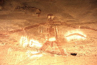
Aboriginal sites of New South Wales consist of a large number of places in the Australian state of New South Wales where it is still possible to see visible signs of the activities and culture of the Australian Aboriginals who previously occupied these areas.

<span class="mw-page-title-main">Bare Creek</span> River in New South Wales, Australia

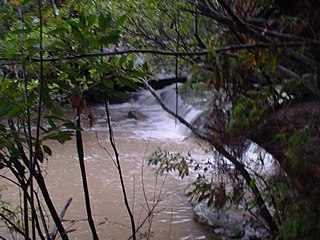
Bare Creek is a watercourse that is part of the Middle Harbour catchment of Sydney Harbour that is located in the northern beaches region of Sydney, New South Wales, Australia.

References

  1. Tim Flannery, The Birth of Sydney Text Publishing, 16 Nov. 1999 ISBN   1-876485-45-0.
  2. 1 2 "Bungaroo, Short histories and oral statements, Middle Harbour, by E Hilder 22 April 1970, Harry Morris 1990 F McLeod 15 May 1983, Ku-ring-gai Library" (PDF). Retrieved 25 June 2017.
  3. The Secret of Bungaroo, by R. Emerson Curtis, The Sydney Mail, 7 March 1934 p.14
  4. "Founders Way Walking Track, Bungaroo". www.visitsydneyaustralia.com.au. Retrieved 25 June 2017.
  5. "Bungaroo Track walking track". www.wildwalks.com.au. Retrieved 25 June 2017.
  6. "National Parks NSW Parknotes" . Retrieved 25 June 2017.
  7. "Bungaroo Walking Track". Ku-ring-gai Council. Retrieved 7 September 2012.
  8. Bushwalk Australia, Bungaroo, accessed 3/7/2017
  9. Davidson Park to Stepping Stone Crossing walk, Garigal National Park, accessed 3/7/2017