Caesar's Camp, Bracknell Forest

Last updated

Bank and ditch at Caesar's Camp Bank and ditch of Caesar's Camp, Bracknell - geograph.org.uk - 729718.jpg
Bank and ditch at Caesar's Camp
3D view of the digital terrain model Caesars Camp Bracknell Forest Digital Terrain Model.jpg
3D view of the digital terrain model

Caesar's Camp is an Iron Age hill fort around 2,400 years old. It is located just in Crowthorne civil parish to the south of Bracknell in the English county of Berkshire. It falls within the Windsor Forest and is well wooded, although parts of the fort have now been cleared of some trees. The area is managed by the Forestry Commission but owned by Crown Estate, and is open and accessible to the public. The hill fort covers an area of about 17.2 acres (7 hectares) and is surrounded by a mile-long ditch, making it one of the largest in southern England. [1]

Contents

Etymology

The origin of the name "Caesar's Camp" is unknown. However, the hill fort is close to the Roman road known as the Devil's Highway, and this may have led Medieval mapmakers to attribute the structure (wrongly) to the Romans.

History

Caesar's Camp is thought to have been established around 500–300BC. It is the only hill fort of its type that has been identified in east Berkshire. [2] Because the area had a thick bed of sandstone beneath the top layers of soil, it was likely not suitable for farming – the community at Caesar's Camp was therefore dependent on the produce of neighbouring settlements. Caesar's Camp was therefore most likely used as an assembly point and a marketplace. Its huge outer walls and 1-mile-long (1.6 km) dump rampart also suggest that it was used as a safe haven in case of attack.

Multivallate defences at Caesar's Camp Caesar's Camp - geograph.org.uk - 1181919.jpg
Multivallate defences at Caesar's Camp

Caesar's Camp appears to have fallen under the rule of Cunobelin, king of the Catuvellauni tribe in the first century AD from a coin discovered in the interior. [2] Soon after, the Romans invaded England; after this time, there is no evidence that Caesar's Camp continued to exist as an inhabited community. A road from its south entrance was later built, connecting it to the Devil's Highway (Roman Britain). There is a small Roman settlement about halfway along this road, known as Wickham Bushes, which has yielded pottery and other Roman artifacts. The main Roman road connected Londinium with Calleva Atrebatum, the tribal capital of the Atrebates, about 10 miles to the west in Hampshire.

A redoubt roughly 40 m across in the fort is thought to be part of a defence line built in 1792 in preparation for the Napoleonic Wars. [1]

Description

Scots pines on bank at Caesar's Camp Pine trees, Caesar's Camp - geograph.org.uk - 1181921.jpg
Scots pines on bank at Caesar's Camp
Heather on upper rampart at Caesar's Camp Caesar's Camp, Bracknell Forest 01.jpg
Heather on upper rampart at Caesar's Camp

The layout consists of a number of steep banks and ditches in the shape of an oak leaf, enclosing a large flat area of a settlement. The main entrance is at its northern end (at the tip of the leaf) and is very well defended with multiple banks and a sinuous entrance road. The banks to the side of the entrance are very steep, guiding any entrants along the way. [3] It is north of the Roman road known as the Devil's Highway which connected Londinium to Calleva Atrebatum (Silchester). It is within the Crowthorne Woods part of Swinley Forest crown plantation and is located off Nine Mile Ride approximately 0.75 miles (1.2 km) from the Look Out visitor centre. Much of the fort is covered by mature broadleaf and coniferous trees, although some of the spruce plantation on the southern part of the fort has been cleared, and the ground reverted to heathland and scrub. On clear days, central Bracknell and Crowthorne, including Broadmoor hospital, are visible from its highest points. The camp falls within the Broadmoor to Bagshot Woods and Heaths Site of Special Scientific Interest, and forms part of the northern edge of the SSI. The zone protects numerous rare birds such as the woodlark and nightjar, as well as its diverse insect life and fauna.

It is an entirely hand-built complex. [4] The camp has suffered significant erosion, both natural and man-made. Efforts have been made by Bracknell Forest Council to restore some of the natural parts. [4] A geophysical survey (examining the sub-structures) of 2 ha in the southern part of the fort was undertaken in 1995 before the restoration work. It found some evidence for sustained occupation and structures; the survey did find a ditch type anomaly within the western ramparts and a scatter of pit type anomalies. [5]

1978 People's Free Festival

The site was reoccupied between 29 August and 8 September 1978, when it became the location of the last of the Windsor Free Festivals in 1978, after the forced removal of those attempting to attend the People's Free Festival, in Windsor Great Park, by police. [6]

See also

Related Research Articles

<span class="mw-page-title-main">Bracknell Forest</span> District in Berkshire, England

Bracknell Forest is a unitary authority area in Berkshire, southern England. It covers the two towns of Bracknell and Sandhurst and the village of Crowthorne and also includes the areas of North Ascot, Binfield, Warfield, and Winkfield. The borough borders Wokingham and the Royal Borough of Windsor & Maidenhead in Berkshire, and also parts of Surrey and Hampshire.

<span class="mw-page-title-main">Roman sites in Great Britain</span>

There are many Roman sites in Great Britain that are open to the public. There are also many sites that do not require special access, including Roman roads, and sites that have not been uncovered.

<span class="mw-page-title-main">Sandhurst, Berkshire</span> Human settlement in England

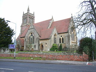
Sandhurst is a town and civil parish in the Bracknell Forest borough in Berkshire, England. It is in the south eastern corner of Berkshire, and is situated 32 miles (51 km) west-southwest of central London, 2.5 miles (4.0 km) north west of Camberley and 5 miles (8.0 km) south of Bracknell. Sandhurst is known worldwide as the location of the Royal Military Academy Sandhurst. Despite its close proximity to Camberley, Sandhurst is also home to a large and well-known out-of-town mercantile development. The site is named "The Meadows" and has a Tesco Extra hypermarket and a Marks & Spencer, two of the largest in the country. A large Next clothing and homeware store is open on the site of the old Homebase.

<span class="mw-page-title-main">Danebury</span> Iron Age hillfort in Hampshire, England

Danebury is an Iron Age hillfort in Hampshire, England, about 19 kilometres (12 mi) north-west of Winchester. The site, covering 5 hectares, was excavated by Barry Cunliffe in the 1970s. Danebury is considered a type-site for hill forts, and was important in developing the understanding of hillforts, as only some others have been so intensively excavated.

<span class="mw-page-title-main">Crowthorne</span> Village in Berkshire, England

Crowthorne is a large village and civil parish in the Bracknell Forest district of south-eastern Berkshire, England. It had a population of 7,806 at the 2021 census. Crowthorne is the venue of Wellington College, a large co-educational boarding and day independent school, which opened in 1859, and of Broadmoor Hospital, one of England's three maximum-security psychiatric hospitals, which lies on the eastern edge of the village.

<span class="mw-page-title-main">Hod Hill</span> Hillfort in Dorset, England

Hod Hill is a large hill fort in the Blackmore Vale, 3 miles (5 km) north-west of Blandford Forum, Dorset, England. The fort sits on a 143 m (469 ft) chalk hill of the same name that lies between the adjacent Dorset Downs and Cranborne Chase. The hill fort at Hambledon Hill is just to the north. The name probably comes from Old English "hod", meaning a shelter, though "hod" could also mean "hood", referring to the shape of the hill.

<span class="mw-page-title-main">Easthampstead</span> Human settlement in England

Easthampstead is a former village and now a southern suburb of the town of Bracknell in the English county of Berkshire, although the old village can still be easily identified around the Church of St Michael and St Mary Magdalene. This building houses some of the finest stained glass works of Sir Edward Burne-Jones.

<span class="mw-page-title-main">Hanworth, Bracknell</span> Human settlement in England

Hanworth is a southern suburb of Bracknell, originally part of the now-defunct civil parish of Easthampstead, in the English county of Berkshire. The Hanworth estate was built in the 1970s upon the site of the wooded Hanworth Plantation. It is bounded by Birch Hill to the east, Great Hollands to the north-west, Easthampstead and the Church Hill estate to the north and the Nine Mile Ride and Crown plantations at Crowthorne Woods to the south. The Iron Age hill fort of Caesar's Camp is basically at Hanworth, although it has been transferred to the parish of Crowthorne.

<span class="mw-page-title-main">Swinley Forest</span> Woodland in Southern England

Swinley Forest is a large expanse of Crown Estate woodland managed by Forestry England mainly within the civil parishes of Windlesham in Surrey and Winkfield and Crowthorne in Berkshire, England.

<span class="mw-page-title-main">Port Way</span> Roman road that ran from Calleva Atrebatum to Sorbiodunum

Port Way is an ancient road in southern England, which ran from Calleva Atrebatum in a south-westerly direction to Sorbiodunum. Often associated with the Roman Empire, the road may have predated the Roman occupation of Britain.

<span class="mw-page-title-main">Broadmoor to Bagshot Woods and Heaths</span>

Broadmoor to Bagshot Woods and Heaths is a 1,696.3-hectare (4,192-acre) biological Site of Special Scientific Interest (SSSI) in Berkshire and Surrey that extend from a minority of the parish of Crowthorne including around Broadmoor Hospital in the west to Bagshot south-east, Bracknell north-east, and Sandhurst, south. It is part of the Thames Basin Heaths Special Protection Area. Two nature reserves which are managed by the Surrey Wildlife Trust are in the SSSI, Barossa nature reserve and Poors Allotment. Broadmoor Bottom, which is part of Wildmoor Heath, also falls within the SSSI; this reserve is managed by the Berkshire, Buckinghamshire and Oxfordshire Wildlife Trust.

Nine Mile Ride is a length of the B3430 road in the English county of Berkshire, running from the south of Bracknell to Finchampstead, in the Borough of Wokingham. Despite its name, the road is 6.7 miles (10.8 km) long.

<span class="mw-page-title-main">Buckland Rings</span> Iron Age hillfort in Hampshire, England

Buckland Rings is the site of an Iron Age hill fort in the town of Lymington, Hampshire. Today, the mounds and dykes around the outside which once constituted its defences are still clearly visible, although the outer bank lies under the road on the west side, and on the south-east it is nearly ploughed-out. Excavations of the inner and middle ramparts in 1935 revealed that they were of wall-and-fill construction, retained at the front by upright timber beams and walls of cut and laid turf. The entrance, which lies on the east side, was also excavated revealing a long entrance passage and the postholes for a pair of stout gateposts. The site was bought by Hampshire County Council in 1989 to ensure its preservation, and it is open to the public from the A337 road onto which part of it faces.

<span class="mw-page-title-main">Blewburton Hill</span> Hillfort in Oxfordshire, England

Blewburton Hill is the site of an Iron Age hillfort located in Oxfordshire, in the southeast of England. It was a univallate hillfort. The area is mostly farmland with some small areas of wooded copse to the south and the northeast. The hill fort may have been occupied from the 4th century BC to the 1st century BC, and replaced a small settlement surrounded by a stockade, which is estimated to have been built in the 5th or 6th century BC.

<span class="mw-page-title-main">Thames Basin Heaths</span>

The Thames Basin Heaths are a natural region in southern England in Berkshire, Hampshire and Surrey, a slightly mottled east-west belt of ecologically recognised and protected land.

<span class="mw-page-title-main">Bigbury Camp</span> Hillfort in Kent, England

Bigbury Camp is a univallate hill fort in the parish of Harbledown and Rough Common in Kent in England. The fort is a Scheduled Ancient Monument, with a list entry identification number of 1005169. Bigbury Camp is the only confirmed Iron Age hill fort in east Kent. It is managed by Kent Wildlife Trust.

<span class="mw-page-title-main">Caesar's Camp, Rushmoor and Waverley</span> Iron Age hillfort in Hampshire, England

<span class="mw-page-title-main">Devil's Highway (Roman Britain)</span> Roman road in England

The Devil's Highway was a Roman road in Britain connecting Londinium (London) to Calleva Atrebatum (Silchester) via Pontes (Staines). The road was the principal route to the west of Britain during the Roman period but whilst maintained for its easternmost section, was replaced by other routes after the demise of Roman Britain.

Dungeon Hill is an Iron Age hillfort, about 1+14 miles north of the village of Buckland Newton in Dorset, England. It is a scheduled monument.

Brandon Camp is an archaeological site, about 1 mile south of Leintwardine, in Herefordshire. England. It is a hillfort of the Iron Age, which later became a Roman fort. The site is a scheduled monument.

References

  1. 1 2 Historic England. "Details from listed building database (1016334)". National Heritage List for England . Retrieved 23 February 2016.
  2. 1 2 Cotton, Aylwin (1962). "Berkshire Hill Forts". Berkshire Archaeological Journal. 60: 30–52. doi:10.5284/1000017 . Retrieved 23 February 2016.
  3. Hogg, A H A (1975). Hill-forts of Britain. Hart-Davis. p. 157. ISBN   978-0246108357.
  4. 1 2 "Caesar's Camp". Bracknell Forest Council. Archived from the original on 3 March 2016. Retrieved 23 February 2016. The hillfort which covers an area of about 17.2 acres (7 hectares) and is surrounded by a mile-long ditch, is a remarkable piece of engineering having been constructed entirely by hand using basic tools.
  5. Linford, N (1995). "Caesar's Camp, Windsor Forest, Berks, Report On Geophysical Survey, 1995". Historic Buildings and Monuments Commission for England . Retrieved 24 February 2016.
  6. "Caesar's Camp free festival −1978- Peoples Free Festival 1978". Ukrockfestivals.com. Retrieved 8 August 2012.

51°22′59″N0°45′36″W / 51.383°N 0.760°W / 51.383; -0.760