Cryna, Queensland

Last updated

Cryna
Queensland
Fields along Markwell Creek Road at Cryna, Queensland 2.jpg
Fields, Markwell Creek Road, 2016
Australia Queensland location map.svg
Red pog.svg
Cryna
Coordinates 28°02′26″S152°59′11″E / 28.0405°S 152.9863°E / -28.0405; 152.9863 Coordinates: 28°02′26″S152°59′11″E / 28.0405°S 152.9863°E / -28.0405; 152.9863
Population113 (2016 census) [1]
 • Density4.93/km2 (12.78/sq mi)
Postcode(s) 4285
Area22.9 km2 (8.8 sq mi)
Time zone AEST (UTC+10:00)
LGA(s) Scenic Rim Region
State electorate(s) Scenic Rim
Federal division(s) Wright
Suburbs around Cryna:
Beaudesert Beaudesert Beaudesert
Josephville Cryna Nindooinbah
Laravale Laravale Kerry

Cryna is a rural locality in the Scenic Rim Region, Queensland, Australia. [2] In the 2016 census, Cryna had a population of 113 people. [1]

Contents

Geography

Part of the western border is marked by the Mount Lindesay Highway. Part of the northern boundary follow Spring Creek. The main land use in the area is agriculture. Parts of the central area are elevated along a ridge marking the northern extent of Jinbroken Range.[ citation needed ]

History

The location name comes from the 1870s agricultural and grazing property of Charles Overend Garbutt (1850–1905). [3] Garbutt came from Marton Hall, Middlesbrough-on-Tees, Yorkshire, England. [4] The 3,400 acres (1,400 hectares) Spring Creek holdings went to auction in December 1877 as Garbutt was moving from the district. [5] It was then purchased by Harry and William Webb until 1882, before being purchased by June 1896 by the Queensland Government under the Agricultural Lands Purchase Act 1894 (and the later Closer Settlement Act 1906) where the property was subdivided into agricultural blocks. [6] [7] [8] [9]

Cryna Provisional School opened on 30 April 1907. [10] [11] On 1 January 1909 it became Cryna State School. It closed in 1935. [12]

The Beaudesert Shire Tramway passed through the area but did not have a station.[ when? ] The closest station was at Josephville or the terminus in Beaudesert.[ citation needed ]

Cryna has a population of 113 at the 2016 census.In the 2016 census, Cryna had a population of 113 people. [1] The locality contains 51 households, in which 52.6% of the population are males and 47.4% of the population are females with a median age of 42, 4 years above the national average. The average weekly household income is $1,281, $157 below the national average. 0.0% of Cryna's population is either of Aborigional or Torres Strait Islander descent. 56.0% of the population aged 15 or over is either registered or de facto married, while 44.0% of the population is not married. 24.1% of the population is currently attending some form of a compulsory education. The most common nominated ancestries were English (37.1%), Australian (30.5%) and Irish (14.6%), while the most common country of birth was Australia (80.7%), and the most commonly spoken language at home was English (100.0%). The most common nominated religions were Catholic (27.4%), No religion (27.4%) and Anglican (15.1%). The most common occupation was a manager (21.8%) and the majority/plurality of residents worked 40 or more hours per week (46.4%). [1]

Related Research Articles

Milton, Queensland Suburb of Brisbane, Queensland, Australia

Milton is a riverside inner suburb of the City of Brisbane, Queensland, Australia. In the 2016 census, the population of Milton was 2,274 people.

Ipswich, Queensland Suburb of Ipswich, Queensland, Australia

Ipswich is an urban region in South East Queensland, Australia. Situated on the Bremer River, it is approximately 40 kilometres (25 mi) west of the Brisbane central business district. A local government area, the City of Ipswich has a population of 232,000. The city is renowned for its architectural, natural and cultural heritage. Ipswich preserves and operates from many of its historical buildings, with more than 6000 heritage-listed sites and over 500 parks. Ipswich began in 1827 as a mining settlement.

Rathdowney, Queensland Town in Queensland, Australia

Rathdowney is a rural town and locality in the Scenic Rim Region, Queensland, Australia. In the 2016 census, Rathdowney had a population of 308 people.

Beaudesert, Queensland Town in Queensland, Australia

Beaudesert is a rural town and locality in the Scenic Rim Region, Queensland, Australia. In the 2016 census, Beaudesert had a population of 6,395 people.

Holland Park, Queensland Suburb of Brisbane, Queensland, Australia

Holland Park is a southern suburb in the City of Brisbane, Queensland, Australia. In the 2016 census, Holland Park had a population of 8,111 people.

Indooroopilly, Queensland Suburb of Brisbane, Queensland, Australia

Indooroopilly is a riverside suburb west of the City of Brisbane, Queensland, Australia. In the 2016 census, Indooroopilly had a population of 12,242 people.

Bulimba, Queensland Suburb of Brisbane, Queensland, Australia

Bulimba is a suburb in the City of Brisbane, Queensland, Australia. In the 2016 census, Bulimba had a population of 6,843 people.

Yeerongpilly, Queensland Suburb of Brisbane, Queensland, Australia

Yeerongpilly is a southern suburb in the City of Brisbane, Queensland, Australia. In the 2016 census, Yeerongpilly had a population of 1,934 people.

Booval, Queensland Suburb of Ipswich, Queensland, Australia

Booval is a suburb of Ipswich in the City of Ipswich, Queensland, Australia. In the 2016 census Booval had a population of 2,622 people.

Logan Village, Queensland Suburb of Logan City, Queensland, Australia

Logan Village is a semi-rural town and locality in the City of Logan, Queensland, Australia. In the 2016 census, the locality of Logan Village had a population of 4,417 people. Logan Village was once known as the head of the navigable Logan River. Its importance as a town grew again when the railway arrived.

Munruben, Queensland Suburb of Logan City, Queensland, Australia

Munruben is a rural locality in the City of Logan, Queensland, Australia. Once a rural community, it has been developed into a low density residential community. In the 2016 census, Munruben had a population of 2,871 people.

Beaudesert Shire Tramway Former tramway in Queensland, Australia

The Beaudesert Shire Tramway was a narrow gauge tramway which operated from Beaudesert to Lamington and Rathdowney in the Scenic Rim Region, Queensland, Australia, It was one of 15 light railways built and operated by Divisional Boards and Shire Councils in Queensland. The line carried passengers and cargo. It operated from 1903 to 1944. It was initially profitable and seen as a great success for the local shire council. The tramway is credited with opening up the agricultural lands of the upper Logan River.

Kerry, Queensland Town in Queensland, Australia

Kerry is a rural locality in the Scenic Rim Region, Queensland, Australia. In the 2016 census, Kerry had a population of 326 people.

Barney View, Queensland Suburb of Scenic Rim Region, Queensland, Australia

Barney View is a rural locality in the Scenic Rim Region, Queensland, Australia. In the 2016 census, Barney View had a population of 64 people.

Josephville, Queensland Town in Queensland, Australia

Josephville is a rural locality in the Scenic Rim Region, Queensland, Australia. In the 2016 census, Josephville had a population of 166 people.

1937 Airlines of Australia Stinson crash

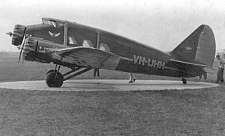
The 1937 Airlines of Australia Stinson crash was an accident which occurred on 19 February 1937. The Airlines of Australia Stinson Model A airliner disappeared during a flight from Brisbane to Sydney, carrying five passengers and two pilots. Both pilots and two passengers were killed in the crash. One of the surviving passengers died while attempting to bring help to the other survivors.

Palen Creek, Queensland Suburb of Scenic Rim Region, Queensland, Australia

Palen Creek is a rural locality in the Scenic Rim Region, Queensland, Australia. It borders New South Wales. In the 2016 census, Palen Creek had a population of 280 people.

Wyaralong, Queensland Suburb of Scenic Rim Region, Queensland, Australia

Wyaralong is a rural locality in the Scenic Rim Region, Queensland, Australia. In the 2016 census, Wyaralong had a population of 20 people.

Mount Gipps, Queensland Suburb of Scenic Rim Region, Queensland, Australia

Mount Gipps is a rural locality in the Scenic Rim Region, Queensland, Australia. In the 2016 census, Mount Gipps had a population of 7 people.

Thomas Plunkett, senior Australian politician

Thomas Plunkett was a farmer and Member of the Queensland Legislative Assembly in Queensland, Australia.

References

  1. 1 2 3 4 Australian Bureau of Statistics (27 June 2017). "Cryna (SSC)". 2016 Census QuickStats. Retrieved 20 October 2018. OOjs UI icon edit-ltr-progressive.svg
  2. "Cryna – locality in Scenic Rim Region (entry 45134)". Queensland Place Names. Queensland Government . Retrieved 5 November 2019.
  3. "Advertising". The Week. Vol. IV, no. 97. Queensland, Australia. 3 November 1877. p. 28. Archived from the original on 25 May 2022. Retrieved 16 September 2020 via National Library of Australia.
  4. "C.W.A. pioneers". Townsville Daily Bulletin . Vol. LIII, no. 31. Queensland, Australia. 5 February 1931. p. 11. Archived from the original on 25 May 2022. Retrieved 16 September 2020 via National Library of Australia.
  5. "Classified Advertising". The Brisbane Courier . Vol. XXXII, no. 3, 255. Queensland, Australia. 23 October 1877. p. 4. Archived from the original on 25 May 2022. Retrieved 16 September 2020 via National Library of Australia.
  6. "Repurchased Lands". The Queenslander . Vol. L, no. 1088. Queensland, Australia. 29 August 1896. p. 426. Archived from the original on 25 May 2022. Retrieved 16 September 2020 via National Library of Australia.
  7. "Agricultural Lands Purchase Act". Queensland Times, Ipswich Herald And General Advertiser. Vol. XXXVIII, no. 5640. Queensland, Australia. 4 September 1897. p. 2. Archived from the original on 25 May 2022. Retrieved 16 September 2020 via National Library of Australia.
  8. "Logan Early Settlers". The Beaudesert Times . Vol. 6, no. 354. Queensland, Australia. 30 July 1915. p. 8. Archived from the original on 25 May 2022. Retrieved 16 September 2020 via National Library of Australia.
  9. "Resumption of estates". The Brisbane Courier . Vol. LXIV, no. 15, 678. Queensland, Australia. 11 April 1908. p. 10. Archived from the original on 25 May 2022. Retrieved 16 September 2020 via National Library of Australia.
  10. "Advertising". The Brisbane Courier . Queensland, Australia. 5 January 1907. p. 16. Archived from the original on 25 May 2022. Retrieved 3 May 2020 via Trove.
  11. "Public Works". The Telegraph . Queensland, Australia. 30 January 1907. p. 8 (SECOND EDITION). Archived from the original on 25 May 2022. Retrieved 3 May 2020 via Trove.
  12. Queensland Family History Society (2010), Queensland schools past and present (Version 1.01 ed.), Queensland Family History Society, ISBN   978-1-921171-26-0

Commons-logo.svg Media related to Cryna, Queensland at Wikimedia Commons