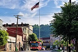
Etna, Pennsylvania

Last updated

Etna, Pennsylvania
Etna Downtown Butler Street.jpg
Butler Street in downtown Etna
Motto: 
Etna is for Everyone
Allegheny County Pennsylvania incorporated and unincorporated areas Etna highlighted.svg
Location in Allegheny County and the U.S. state of Pennsylvania
CountryUnited States
StatePennsylvania
County Allegheny
Area
[1]
  Total0.80 sq mi (2.07 km2)
  Land0.74 sq mi (1.91 km2)
  Water0.07 sq mi (0.17 km2)
Population
 (2020) [2]
  Total3,437
  Density4,669.84/sq mi (1,803.06/km2)
Time zone UTC-5 (EST)
  Summer (DST) UTC-4 (EDT)
ZIP code
15223
FIPS code 42-24160
Website www.etnaborough.org

Etna is a borough in Allegheny County, Pennsylvania, United States, located across the Allegheny River from Pittsburgh. The population was 3,437 at the 2020 census. [3] It is a suburb of the Pittsburgh metropolitan area.

Contents

Etna was named after the Sicilian volcano Mount Etna, an allusion to blast furnaces, steel mills, galvanized-pipe works, and other manufacturers located there. [4] Historically, it was a steel town with a blue-collar community. The Isabella Furnace of Carnegie Steel was located in Etna, operating until 1953. [5] In 2019, Etna was recognized as the first ever ecodistrict.

Geography

Etna is located at 40°30′1″N79°56′56″W / 40.50028°N 79.94889°W / 40.50028; -79.94889 (40.500338, −79.948755). [6] It is located off Route 28 from Pittsburgh and borders the Allegheny river and Pine Creek.

According to the United States Census Bureau, the borough has a total area of 0.8 square miles (2.1 km2), all land.

Surrounding communities

Etna is almost entirely bordered by Shaler Township with its only other border being with the borough of Sharpsburg to the southeast. Nearby to the west is Millvale and Pittsburgh is immediately across the Allegheny River to the south.

Demographics

Historical population
CensusPop.Note
1870 1,447
1880 2,33461.3%
1890 3,70758.8%
1900 5,38445.2%
1910 5,8308.3%
1920 6,3418.8%
1930 7,49318.2%
1940 7,223−3.6%
1950 6,750−6.5%
1960 5,519−18.2%
1970 5,8195.4%
1980 4,534−22.1%
1990 4,200−7.4%
2000 3,924−6.6%
2010 3,451−12.1%
2020 3,437−0.4%
Sources: [7] [8] [9] [10] [11] [12] [13] [2]

As of the 2000 census, [12] there were 3,924 people, 1,749 households, and 981 families residing in the borough. The population density was 5,254.8 inhabitants per square mile (2,028.9/km2). There were 1,934 housing units at an average density of 2,589.9 per square mile (1,000.0/km2). The racial makeup of the borough was 97.78% White, 0.76% African American, 0.36% Native American, 0.15% Asian, 0.15% from other races, and 0.79% from two or more races. Hispanic or Latino of any race were 1.15% of the population.

There were 1,749 households, out of which 26.6% had children under the age of 18 living with them, 38.2% were married couples living together, 13.7% had a female householder with no husband present, and 43.9% were non-families. 38.5% of all households were made up of individuals, and 15.8% had someone living alone who was 65 years of age or older. The average household size was 2.22 and the average family size was 3.01.

In the borough the population was spread out, with 22.6% under the age of 18, 8.0% from 18 to 24, 31.7% from 25 to 44, 20.6% from 45 to 64, and 17.1% who were 65 years of age or older. The median age was 39 years. For every 100 females there were 89.1 males. For every 100 females age 18 and over, there were 84.6 males.

The median income for a household in the borough was $31,529, and the median income for a family was $41,577. Males had a median income of $31,386 versus $23,601 for females. The per capita income for the borough was $17,580. About 7.5% of families and 9.2% of the population were below the poverty line, including 12.0% of those under age 18 and 17.5% of those age 65 or over.

Parks and recreation

Etna River Front Park EtnaRiverfrontPark.png
Etna River Front Park

The Etna Riverfront Trail opened October 22, 2021. The Etna segment of the Riverfront trail project will connect via bike path to a series of Riverfront Parks including Millvale, North Shore, Sharpsburg and Aspinwall.

Etna Riverfront is a recreational area that borders the Allegheny River, with paved walking paths, lookout spots, benches and picnic tables.

Dougherty Nature Trail is a walking trail behind Dougherty Veteran's Field that runs along Pine Creek. Dougherty Nature Trail is accessible from Crescent Street by Dougherty Veteran's Field and a pedestrian bridge to Pine Street past the Etna Park.

Education

Etna is part of the Shaler Area School District, which encompasses multiple of Pittsburgh's northern suburbs.

Related Research Articles

<span class="mw-page-title-main">Aspinwall, Pennsylvania</span> Borough of Pennsylvania, United States

Aspinwall is a borough on the Allegheny River in Allegheny County, Pennsylvania, United States. It is part of the Pittsburgh metropolitan area. The population was 2,916 at the 2020 census.

<span class="mw-page-title-main">Blawnox, Pennsylvania</span> Borough in Pennsylvania, United States

Blawnox is a borough in Allegheny County, Pennsylvania, United States. The population was 1,454 at the 2020 census. It is part of the Pittsburgh metropolitan area.

<span class="mw-page-title-main">Brackenridge, Pennsylvania</span> Borough in Pennsylvania, United States

Brackenridge is a borough in Allegheny County, Pennsylvania, United States, located along the Allegheny River. It is part of the Greater Pittsburgh metropolitan area.

<span class="mw-page-title-main">Chalfant, Pennsylvania</span> Borough in Pennsylvania, United States

Chalfant is a borough in Allegheny County, Pennsylvania, United States. The population was 748 at the 2020 census.

<span class="mw-page-title-main">Churchill, Pennsylvania</span> Borough in Pennsylvania, United States

Churchill is a borough in Allegheny County, Pennsylvania, United States. The population was 3,157 at the 2020 census. It is a residential suburb of the Pittsburgh metropolitan area. The town was named from the hilltop Beulah Presbyterian Church.

<span class="mw-page-title-main">East McKeesport, Pennsylvania</span> Borough in Pennsylvania, United States

East McKeesport is a borough in Allegheny County, Pennsylvania, United States, and is part of the Pittsburgh Metro Area. The population was 2,076 at the 2020 census.

<span class="mw-page-title-main">East Pittsburgh, Pennsylvania</span> Borough in Pennsylvania, United States

East Pittsburgh is a borough in Allegheny County, Pennsylvania, United States, approximately 11 miles (18 km) southeast of the confluence of the Monongahela and the Allegheny rivers at Pittsburgh. The population in 1900 stood at 2,883, and in 1910, at 5,615. As of the 2020 census, the borough population was 1,927, having fallen from 6,079 in 1940. George Westinghouse erected large works there which supplied equipment to the great power plants at Niagara Falls and for the elevated and rapid-transit systems of New York City. Nearby, the George Westinghouse Bridge over Turtle Creek is a prominent fixture in the area, which is very near the borough of Braddock.

<span class="mw-page-title-main">Jefferson Hills, Pennsylvania</span> Borough in Pennsylvania, United States

Jefferson Hills is a borough in Allegheny County, Pennsylvania, United States. In the 2020 census, the population was 12,424. It is part of the Pittsburgh metropolitan area.

<span class="mw-page-title-main">Millvale, Pennsylvania</span> Borough in Pennsylvania, United States

Millvale is a borough in Allegheny County, Pennsylvania, United States, along the Allegheny River, opposite Pittsburgh. The borough is located off Pennsylvania Route 28. The population was 3,376 at the 2020 census.

<span class="mw-page-title-main">Munhall, Pennsylvania</span> Borough in Pennsylvania, United States

Munhall is a borough in Allegheny County, Pennsylvania, United States, on the west bank of the Monongahela River. The population was 10,774 at the 2020 census. It is a residential suburb of the Pittsburgh metropolitan area.

<span class="mw-page-title-main">Pleasant Hills, Pennsylvania</span> Borough in Pennsylvania, United States

Pleasant Hills is a borough in Allegheny County, Pennsylvania, United States. As of the 2020 census, the population was 8,504. It is a suburb of the Pittsburgh metropolitan area.

<span class="mw-page-title-main">Sharpsburg, Pennsylvania</span> Borough in Pennsylvania, United States

Sharpsburg is a borough in Allegheny County, Pennsylvania, United States, 5 miles (8 km) northeast of downtown Pittsburgh, along the Allegheny River. In 1900, nearly 7,000 people lived here; in 1920, the population peaked at just over 8,900 people. The population was 3,187 at the 2020 census.

<span class="mw-page-title-main">Turtle Creek, Pennsylvania</span> Borough in Pennsylvania, United States

Turtle Creek is a borough in Allegheny County, Pennsylvania, United States, 12 miles (19 km) southeast of Pittsburgh. The population was 5,114 at the 2020 census. George Westinghouse constructed a manufacturing plant nearby. Turtle Creek takes its name from a small stream that flows into the Monongahela River. Before white settlers arrived, there was a small village of Native Americans living there from the Turtle Clan of the Iroquois Nation.

<span class="mw-page-title-main">Verona, Pennsylvania</span> Borough in Pennsylvania, United States

Verona is a borough in Allegheny County, Pennsylvania, United States. It is 13 miles (21 km) northeast of downtown Pittsburgh, along the left bank of the Allegheny River. As of the 2020 census, the borough had a population of 2,492.

<span class="mw-page-title-main">Whitaker, Pennsylvania</span> Borough in Pennsylvania, United States

Whitaker is a borough in Allegheny County, Pennsylvania, United States, and is on the Monongahela River 3 miles (5 km) upriver from Pittsburgh. The population was 1,179 at the 2020 census.

<span class="mw-page-title-main">Smithton, Pennsylvania</span> Borough in Pennsylvania, United States

Smithton is a borough in Westmoreland County, Pennsylvania, United States. The population was 399 at the 2010 census. As of 2018, the population was listed at 378. Smithton has its own post office, with zip code 15479, and is serviced by Yough School District.

<span class="mw-page-title-main">Trafford, Pennsylvania</span> Borough in Pennsylvania, United States

Trafford is a borough in Allegheny and Westmoreland counties in the U.S. state of Pennsylvania. Located near Pittsburgh in western Pennsylvania, the borough lies primarily in Westmoreland County; only a small portion extends into Allegheny County. It was incorporated in 1904 from the northernmost corner of North Huntingdon Township, and was named by George Westinghouse for Trafford near Manchester, England. Westinghouse purchased the land in 1902, and the Trafford Foundry began operations on October 3, 1903. The population was 3,317 at the 2020 census. Of this, 3,113 were in Westmoreland County, and only 61 were in Allegheny County.

<span class="mw-page-title-main">Hampton Township, Allegheny County, Pennsylvania</span> Township in Pennsylvania, United States

Hampton Township is a township in Allegheny County, Pennsylvania, United States. The population was 18,470 at the 2020 census. It is a suburb of the Pittsburgh metropolitan area.

<span class="mw-page-title-main">O'Hara Township, Pennsylvania</span> Township in Pennsylvania, United States

O'Hara Township is a township with home rule status in Allegheny County, Pennsylvania, United States, six miles northeast of Downtown Pittsburgh. The community was long organized as a township, and retains "Township" in its official name, but adopted a home rule charter in 1973 and is no longer subject to the Pennsylvania Township Code. The population was 9,288 at the 2020 census.

<span class="mw-page-title-main">Shaler Township, Pennsylvania</span> Township in Pennsylvania, United States

Shaler Township is a township in Allegheny County in the U.S. state of Pennsylvania. It consists of much of the community of Glenshaw and several neighboring communities. The population was 28,757 at the 2010 census. It is part of the Pittsburgh metropolitan area.

References

  1. "ArcGIS REST Services Directory". United States Census Bureau. Retrieved October 15, 2022.
  2. 1 2 "Census Population API". United States Census Bureau. Retrieved October 12, 2022.
  3. "Explore Census Data".
  4. "What's in a name? For some, a bit of history". Pittsburgh Post-Gazette. May 10, 1984. p. 2. Retrieved May 16, 2015.
  5. "Close Down Isabella". Iron Age. Chilton Company. 172: 155. 1953.
  6. "US Gazetteer files: 2010, 2000, and 1990". United States Census Bureau. February 12, 2011. Retrieved April 23, 2011.
  7. "Population of Civil Divisions Less than Counties" (PDF). 1880 United States Census. U.S. Census Bureau. Retrieved November 24, 2013.
  8. "Population-Pennsylvania" (PDF). U.S. Census 1910. U.S. Census Bureau. Retrieved November 22, 2013.
  9. "Number and Distribution of Inhabitants:Pennsylvania-Tennessee" (PDF). Fifteenth Census. U.S. Census Bureau.
  10. "Number of Inhabitants: Pennsylvania" (PDF). 18th Census of the United States. U.S. Census Bureau. Retrieved November 22, 2013.
  11. "Pennsylvania: Population and Housing Unit Counts" (PDF). U.S. Census Bureau. Retrieved November 22, 2013.
  12. 1 2 "U.S. Census website". United States Census Bureau . Retrieved January 31, 2008.
  13. "Annual Estimates of the Resident Population". U.S. Census Bureau. Archived from the original on November 20, 2013. Retrieved November 22, 2013.
Preceded by Bordering communities
of Pittsburgh
Succeeded by