Thermal radiation is electromagnetic radiation emitted by the thermal motion of particles in matter. All matter with a temperature greater than absolute zero emits thermal radiation. The emission of energy arises from a combination of electronic, molecular, and lattice oscillations in a material. Kinetic energy is converted to electromagnetism due to charge-acceleration or dipole oscillation. At room temperature, most of the emission is in the infrared (IR) spectrum, though above around 525 °C (977 °F) enough of it becomes visible for the matter to visibly glow. This visible glow is called incandescence. Thermal radiation is one of the fundamental mechanisms of heat transfer, along with conduction and convection.

Infrared thermography (IRT), thermal video or thermal imaging, is a process where a thermal camera captures and creates an image of an object by using infrared radiation emitted from the object in a process, which are examples of infrared imaging science. Thermographic cameras usually detect radiation in the long-infrared range of the electromagnetic spectrum and produce images of that radiation, called thermograms. Since infrared radiation is emitted by all objects with a temperature above absolute zero according to the black body radiation law, thermography makes it possible to see one's environment with or without visible illumination. The amount of radiation emitted by an object increases with temperature; therefore, thermography allows one to see variations in temperature. When viewed through a thermal imaging camera, warm objects stand out well against cooler backgrounds; humans and other warm-blooded animals become easily visible against the environment, day or night. As a result, thermography is particularly useful to the military and other users of surveillance cameras.

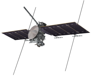
The Thermal Emission Imaging System (THEMIS) is a camera on board the 2001 Mars Odyssey orbiter. It images Mars in the visible and infrared parts of the electromagnetic spectrum in order to determine the thermal properties of the surface and to refine the distribution of minerals on the surface of Mars as determined by the Thermal Emission Spectrometer (TES). Additionally, it helps scientists to understand how the mineralogy of Mars relates to its landforms, and it can be used to search for thermal hotspots in the Martian subsurface.
Thermal infrared spectroscopy is the subset of infrared spectroscopy that deals with radiation emitted in the infrared part of the electromagnetic spectrum. The emitted infrared radiation, though similar to blackbody radiation, is different in that the radiation is banded at characteristic vibrations in the material. The method measures the thermal infrared radiation emitted from a volume or surface. This method is commonly used to identify the composition of surface by analyzing its spectrum and comparing it to previously measured materials. It is particularly suited to airborne and spaceborne applications.
Lunar water is water that is present on the Moon. The search for the presence of lunar water has attracted considerable attention and motivated several recent lunar missions, largely because of water's usefulness in making long-term lunar habitation feasible.

Multispectral imaging captures image data within specific wavelength ranges across the electromagnetic spectrum. The wavelengths may be separated by filters or detected with the use of instruments that are sensitive to particular wavelengths, including light from frequencies beyond the visible light range. It can allow extraction of additional information the human eye fails to capture with its visible receptors for red, green and blue. It was originally developed for military target identification and reconnaissance. Early space-based imaging platforms incorporated multispectral imaging technology to map details of the Earth related to coastal boundaries, vegetation, and landforms. Multispectral imaging has also found use in document and painting analysis.

Philip Russel Christensen is a geologist whose research interests focus on the composition, physical properties, processes, and morphology of planetary surfaces, with an emphasis on Mars and the Earth. He is currently a Regents' Professor and the Ed and Helen Korrick Professor of Geological Sciences at Arizona State University (ASU).
Themis is one of the twelve Titan children of Gaia and Uranus in Greek mythology.

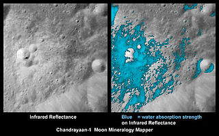
The Moon Mineralogy Mapper (M3) is one of two instruments of NASA that was carried by India's first mission to the Moon, Chandrayaan-1, launched October 22, 2008. It is an imaging spectrometer, and the team is led by Principal investigator Carle Pieters of Brown University, and managed by NASA's Jet Propulsion Laboratory.
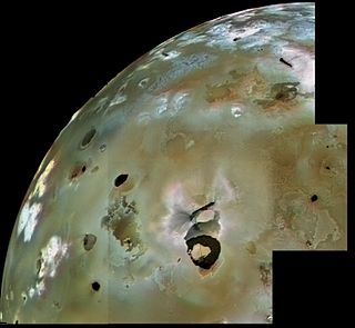
Loki Patera is the largest volcanic depression on Jupiter's moon Io, 202 kilometres (126 mi) in diameter. It contains an active lava lake, with an episodically overturning crust. The level of activity seen is similar to a superfast spreading mid-ocean ridge on Earth. It is the largest volcano on Io, producing about 10% of Io’s total thermal emission. Temperature measurements of thermal emission at Loki Patera taken by Voyager 1's Infrared Interferometer Spectrometer and Radiometer (IRIS) instrument were consistent with sulfur volcanism.
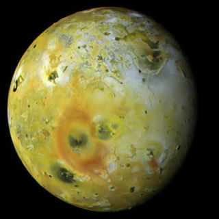
Pele is an active volcano on the surface of Jupiter's moon Io. It is located on Io's trailing hemisphere at 18.7°S 255.3°W. A large, 300-kilometer (190 mi) tall volcanic plume has been observed at Pele by various spacecraft starting with Voyager 1 in 1979, though it has not been persistent. The discovery of the Pele plume on March 8, 1979 confirmed the existence of active volcanism on Io. The plume is associated with a lava lake at the northern end of the mountain Danube Planum. Pele is also notable for a persistent, large red ring circling the volcano resulting from sulfurous fallout from the volcanic plume.

Volcanism on Io, a moon of Jupiter, is represented by the presence of volcanoes, volcanic pits and lava flows on the surface. Io's volcanic activity was discovered in 1979 by Linda Morabito, an imaging scientist working on Voyager 1. Observations of Io by passing spacecraft and Earth-based astronomers have revealed more than 150 active volcanoes. As of 2024, up to 400 such volcanoes are predicted to exist based on these observations. Io's volcanism makes the satellite one of only four known currently volcanically or cryovolcanically active worlds in the Solar System

The formation of carbonates on Mars have been suggested based on evidence of the presence of liquid water and atmospheric carbon dioxide in the planet's early stages. Moreover, due to their utility in registering changes in environmental conditions such as pH, temperature, fluid composition, carbonates have been considered as a primary target for planetary scientists' research. However, since their first detection in 2008, the large deposits of carbonates that were once expected on Mars have not been found, leading to multiple potential explanations that can explain why carbonates did not form massively on the planet.

Mawrth Vallis is a valley on Mars, located in the Oxia Palus quadrangle at 22.3°N, 343.5°E with an elevation approximately two kilometers below datum. Situated between the southern highlands and northern lowlands, the valley is a channel formed by massive flooding which occurred in Mars’ ancient past. It is an ancient water outflow channel with light-colored clay-rich rocks.

Bruce Martin Jakosky is a professor of Geological Sciences and associate director of the Laboratory for Atmospheric and Space Physics (LASP) at the University of Colorado, Boulder. He has been involved with the Viking, Solar Mesosphere Explorer, Clementine, Mars Observer, Mars Global Surveyor, Mars Odyssey, Mars Science Laboratory and MAVEN spacecraft missions, and is involved in planning future spacecraft missions.
The mineralogy of Mars is the chemical composition of rocks and soil that encompass the surface of Mars. Various orbital crafts have used spectroscopic methods to identify the signature of some minerals. The planetary landers performed concrete chemical analysis of the soil in rocks to further identify and confirm the presence of other minerals. The only samples of Martian rocks that are on Earth are in the form of meteorites. The elemental and atmospheric composition along with planetary conditions is essential in knowing what minerals can be formed from these base parts.
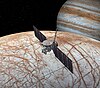
Europa Clipper is a space probe developed by NASA to study Europa, a Galilean moon of Jupiter. It was launched on October 14, 2024, and is expected to arrive in the Jupiter system in 2030. The spacecraft will then perform a series of flybys of Europa while in orbit around Jupiter. The spacecraft is larger than any other used for previous NASA planetary missions.

Zamama is an active volcanic center on Jupiter's moon Io. This volcanic center erupted after the Voyager 1 flyby in 1979, making it one of the few planetary volcanoes known to have activated during this generation's lifetime. Further analysis and study by the Galileo spacecraft helped with the overall study of Io's volcanism. Galileo located it on Io at 21°N173°W. Zamama has a fissure-fed-type flow that is 150 km (93 mi) long with temperatures of 1,100 K, and the volcanic center site has explosive and effusive eruption characteristics. The flow appears to be emanating from the Promethean-type volcano.
The Mapping Imaging Spectrometer for Europa (MISE) is an imaging near infrared spectrometer on board the Europa Clipper mission to Jupiter's moon Europa. MISE will examine Europa's surface composition and relate it to the habitability of its internal water ocean.
Lunar Trailblazer is a planned small lunar orbiter, part of NASA's SIMPLEx program, that will detect and map water on the lunar surface to determine how its form, abundance, and location relate to geology. Its mission is to aid in the understanding of lunar water and the Moon's water cycle. Lunar Trailblazer is currently slated to launch in January 2025 as a secondary payload on the IM-2 mission. The Principal Investigator (PI) of the mission is Bethany Ehlmann, a professor at Caltech.