
Hadfield is a town in the High Peak of Derbyshire,England,with a population at the 2021 Census of 6,763. It lies on the south side of the River Etherow,near to the border with Greater Manchester,at the western edge of the Peak District close to Glossop. It doubled as the fictional town of Royston Vasey in the BBC comedy series The League of Gentlemen.

The Woodhead line was a railway line linking Sheffield,Penistone and Manchester in the north of England. A key feature of the route is the passage under the high moorlands of the northern Peak District through the Woodhead Tunnels. The line was electrified in 1953 and closed between Hadfield and Penistone in 1981.

Stockport railway station serves the large market and industrial town of Stockport in Greater Manchester,England. It is located 6 miles south-east of Manchester Piccadilly,on a spur of the West Coast Main Line to London Euston.
Marple railway station serves the town of Marple,in Greater Manchester,England. It is a stop on the Hope Valley Line,sited 8.9 miles (14.3 km) south-east of Manchester Piccadilly. The station opened in 1865 by the Manchester,Sheffield and Lincolnshire Railway;it was demolished and rebuilt in 1970. It is managed and served by Northern Trains,who generally provide two trains per hour in each direction. Rose Hill Marple station also serves the town on a spur of the Hope Valley Line which,until 1970,continued towards Macclesfield.

Romiley railway station serves Romiley,in the Metropolitan Borough of Stockport,Greater Manchester,England. It is sited at a junction of two parts of the Hope Valley Line,providing services between Manchester Piccadilly,New Mills Central and Sheffield,and also between Piccadilly and Rose Hill Marple.
Ashburys railway station serves the area of Openshaw,in Greater Manchester,England. It is a stop on a junction of the Glossop Line,the Hope Valley line and the freight line to Phillips Park Junction. It has been open since 1855 and is the nearest station to the City of Manchester Stadium.
Hyde Central is the main railway station serving Hyde,in Greater Manchester,England;other stations in the town include Hyde North,Flowery Field and Newton for Hyde. It is a stop on the Hope Valley line,hosting services between Manchester Piccadilly and Rose Hill Marple.

Hyde North is a railway station serving the north of Hyde,Greater Manchester,England. It is managed by Northern Trains,who also operate all services that stop here.

Guide Bridge railway station serves Guide Bridge in Audenshaw,Greater Manchester,England,and is operated by Northern Trains. The station is 4+3⁄4 miles (7.6 km) east of Manchester Piccadilly on both the Rose Hill Marple and Glossop Lines.

The Stockport–Stalybridge line is a railway line in Greater Manchester,England,running north-east from Stockport to Stalybridge,via Guide Bridge. The line is used mainly by freight and empty stock workings,although it once had a frequent passenger service. In 1992,the service pattern reduced to a single weekly passenger train but,in 2018,this was increased to twice a week:one service in each direction on Saturday mornings. Services are operated by Northern,usually with a Class 150 diesel multiple unit. The line is intended to be electrified as part of the Transpennine Route Upgrade.

Gorton railway station serves the Gorton district of the city of Manchester,England. It is sited 2+1⁄2 miles (4.0 km) east of Manchester Piccadilly. The station is a stop on the Glossop and Hope Valley lines;Northern Trains operate all services that stop here and also manage the station.

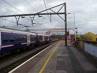
The Glossop line is a railway line connecting the city of Manchester with the towns of Hadfield and Glossop in Derbyshire,England. It formed part of the historic Great Central Main Line between Manchester Piccadilly and Sheffield Victoria. Passenger services on the line are operated by Northern Trains.

Knutsford railway station serves the town of Knutsford in Cheshire,England. The station is 21+3⁄4 miles (35.0 km) south of Manchester Piccadilly on the Mid-Cheshire Line to Chester. The line is referred to as the Chester via Altrincham line at Manchester Piccadilly,but as the Manchester via Stockport line at Chester station.

Godley railway station serves the Godley area of Hyde,Tameside,Greater Manchester,England. It is 8+1⁄2 miles (13.7 km) east of Manchester Piccadilly on the Manchester-Glossop Line.

Newton for Hyde railway station,serves the Newton area of Hyde in Greater Manchester,England. Newton for Hyde is 7+1⁄2 miles (12.1 km) east of Manchester Piccadilly station and managed by Northern Trains. The station unusually features both a covered subway underneath the platforms and a larger viaduct tunnel accessible from both sides,meaning there are 2 ways to cross platforms underground. The eastern side of the station containing these passageways is raised on the viaduct.
Broadbottom railway station serves the village of Broadbottom in Greater Manchester,England. It is on the Manchester-Glossop Line,10 miles (16 km) east of Manchester Piccadilly. It was opened by the Sheffield,Ashton-Under-Lyne and Manchester Railway in 1842. It was renamed Mottram in 1845,but has since reverted to its original name.

Dinting railway station serves the village of Dinting in Derbyshire,England. It is a stop on the Glossop line and,prior to the Woodhead Line's closure in 1981,Dinting was a station on the Great Central Main Line between Manchester Piccadilly and Sheffield Victoria.
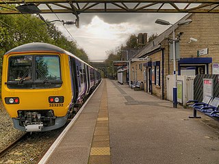
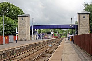
Hadfield railway station serves the Peak District town of Hadfield in Derbyshire,England. The station is one of the twin termini at the Derbyshire end of the Manchester-Glossop Line,the other being Glossop. It was opened by the Sheffield,Ashton-under-Lyne and Manchester Railway in 1844.
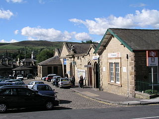
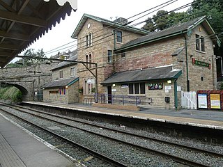
Glossop railway station serves the Peak District town of Glossop in Derbyshire,England. Glossop is the third busiest railway station in the county of Derbyshire after Derby and Chesterfield. It is located just north of Norfolk Square in the centre of Glossop.
