Cutchogue is a hamlet and census-designated place (CDP) in Suffolk County, New York, United States, on the North Fork of Long Island's East End. The population was 3,349 at the 2010 census.

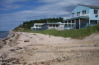
Montauk is a hamlet and census-designated place (CDP) in the Town of East Hampton in Suffolk County, New York, on the eastern end of the South Shore of Long Island. As of the 2020 United States census, the CDP's population was 4,318.

Southold is a census-designated place (CDP) that generally corresponds to the hamlet by the same name in the Town of Southold in Suffolk County, New York, United States. The CDP population was 5,748 at the 2010 census.

The Town of Southold is one of ten towns in Suffolk County, New York, United States. It is located in the northeastern tip of the county, on the North Fork of Long Island. The population was 23,732 at the 2020 census. The town contains a hamlet, also named Southold, which was settled in 1640.

Starved Rock State Park is a state park in the U.S. state of Illinois, characterized by the many canyons within its 2,630 acres (1,064 ha). Located just southeast of the village of Utica, in Deer Park Township, LaSalle County, Illinois, along the south bank of the Illinois River, the park hosts over two million visitors annually, the most for any Illinois state park.

The Town of East Hampton is located in southeastern Suffolk County, New York, at the eastern end of the South Shore of Long Island. It is the easternmost town in the state of New York. At the time of the 2020 United States census, it had a total population of 28,385.

Hither Hills State Park is a 1,755-acre (7.10 km2) state park located on the eastern end of the South Fork of Long Island near the hamlet of Montauk, New York.

The American Battlefield Trust is a charitable organization whose primary focus is in the preservation of battlefields of the Revolutionary War, the War of 1812, and the American Civil War, through the acquisition of battlefield land. The American Battlefield Trust was formerly known as the Civil War Trust. On May 8, 2018, the organization announced the creation of the American Battlefield Trust as the umbrella organization for two divisions, the Civil War Trust and the Revolutionary War Trust, which was formerly known as "Campaign 1776".

Camp Hero State Park is a 754-acre (3.05 km2) state park located on Montauk Point, New York. The park occupies a portion of the former Montauk Air Force Station.
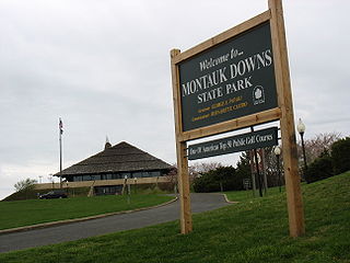
Montauk Downs State Park is a state park in Montauk, New York, United States. The park is located in Suffolk County near the eastern tip of Long Island's South Fork, about one mile (1.6 km) east of the hamlet of Montauk. Montauk Downs State Park includes an 18-hole championship golf course, driving range, tennis courts, swimming pool, and restaurant facilities.

The Montaukett ("Metoac"), more commonly known as Montauk, are an Algonquian-speaking Native American people from the eastern and central sections of Long Island, New York.

Austin Corbin was a 19th-century American banking and railroad entrepreneur. He consolidated the rail lines on Long Island, bringing them under the profitable umbrella of the Long Island Rail Road (LIRR).

Montauk County Park, formerly known as Theodore Roosevelt County Park, is located approximately three miles (4.8 km) east of Montauk, New York. The park is 1,157 acres (4.68 km2) in size, running from Montauk Highway north to Block Island Sound and is bordered on the east by Montauk Point State Park.
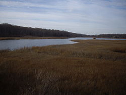
Fort Pond Bay is a bay off Long Island Sound at Montauk, New York that was site of the first port on the end of Long Island. The bay has a long naval and civilian history.

Fort Massapeag Archeological Site is a historic archaeological site at Sunset Park in Massapequa, New York. It is believed to be the site of a New Netherland trading post built in the mid-17th century to facilitate trade with local Native Americans, and possibly serve as a wampum factory. It was first excavated in the 1930s by a team including Ralph Solecki. It was declared a National Historic Landmark in 1993.

Fort Shantok, in Montville, Connecticut, United States, was the site of the principal Mohegan settlement between 1636 and 1682 and the sacred ground of Uncas, one of the most prominent and influential Mohegan leaders and statesmen of his era. Originally part of Mohegan reservation lands, the property was taken by the state of Connecticut in the 20th century and Fort Shantok State Park was established. In 1995, following legal action by the tribe to recover its lands, the state returned the park to Mohegan control. The tribe now operates the area, part of its reservation, as a local park. The grounds were declared a National Historic Landmark in 1993.

Long Island has had a long recorded history from the first European settlements in the 17th century to today. Greatly influenced by construction of railroads in the 19th century, it experienced growth in tourism as well as the development of towns and villages into some of the first modern suburbs in the United States.
Poggatacut also known as Youghco or Poggatticut, was sachem of the Manhasset Indian people of Shelter Island, New York and elder brother to Montaukett Sachem Wyandanch. Sachem Poggatacut and his wife Aswaw granted possession to Lion Gardiner for Gardiners Island in 1639. It was conveyed when they deeded Manchonat, an Island between the north and south fork in exchange for goods and alliance. By 1644 he had united the Corchaug, Shinnecock, Manhassets and Montaukett before retreating as Grand Sachem to his redoubt on Shelter Island, relinquishing control over the tribes to his younger brother, sachem Wyandanch. As “Sachem of Paumanacke", as Long Island was called, he was empowered to make treaties for the Montauketts.
Richmond Hill Historic District is a national historic district in Richmond Hill, Queens, New York. It is bounded to the north by Park Lane South, to the east by 118th Street, to the south by Myrtle Avenue. The district includes 200 contributing buildings built between 1890 and 1915 next to the former South Side Railroad line and the Richmond Hill station at Hillside Avenue, shaped roughly like a triangle. They consist mainly of architectural styles dating back to an earlier time of Academic Eclecticism in home building and were constructed for railroad commuters. Most of the contributing properties were planned as suburbs to Brooklyn and Manhattan. It also included smaller houses built between 1917 and 1930 at the beginning of the Great Depression.