
South Carolina is a state in the coastal Southeastern region of the United States. It is bordered to the north by North Carolina, to the southeast by the Atlantic Ocean, and to the southwest by Georgia across the Savannah River. South Carolina is the 40th most extensive and 23rd most populous U.S. state with a recorded population of 5,124,712 according to the 2020 census. In 2019, its GDP was $213.45 billion. South Carolina is composed of 46 counties. The capital is Columbia with a population of 137,300 in 2020; while its largest city is Charleston with a 2020 population of 150,277. The Greenville–Spartanburg-Anderson metropolitan area is the most populous in the state, with a 2020 population estimate of 1,455,892.
Elgin is an incorporated town in Kershaw County, South Carolina, United States. Some portions of the town are in adjacent Richland County, South Carolina. It is located approximately 20 miles (32 km) northeast of the center of Columbia, the state's capital, and is the center of one of the ten townships that make up Kershaw County. As of the 2010 census, the town's population was 1,311, and in 2018 the estimated population was 1,579. It is part of the Columbia, South Carolina Metropolitan Statistical Area.

The Piedmont is a plateau region located in the Eastern United States. It is situated between the Atlantic Plain and the main Appalachian Mountains, stretching from New York in the north to central Alabama in the south. The Piedmont Province is a physiographic province of the larger Appalachian division which consists of the Gettysburg-Newark Lowlands, the Piedmont Upland, and the Piedmont Lowlands sections.

The geography of North Carolina falls naturally into three divisions — the Appalachian Mountains in the west, the central Piedmont Plateau, and the eastern Atlantic Coastal Plain. North Carolina covers 53,819 square miles (139,391 km2) and is 503 miles (810 km) long by 150 miles (241 km) wide. The physical characteristics of the state vary from the summits of the Smoky Mountains, an altitude of near seven thousand feet (2,130 m) in the west, sloping eastward to sea level along the coast and beaches of the Atlantic Ocean.
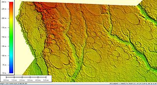
Carolina bays are elliptical to circular depressions concentrated along the East Coast of the United States within coastal New York, New Jersey, Delaware, Maryland, Virginia, North Carolina, South Carolina, Georgia, and north Florida. In Maryland, they are called Maryland basins. Within the Delmarva Peninsula, they and other coastal ponds are also called Delmarva bays.
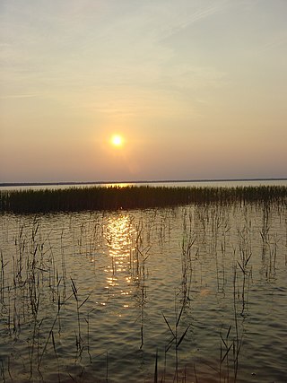
Lake Waccamaw State Park is a North Carolina state park in Columbus County, North Carolina, in the United States. Located near the town of Lake Waccamaw, North Carolina, it covers 2,398-acre (9.70 km2), along the shores of Lake Waccamaw, a Carolina bay. Recent work by the U.S. Geological Survey has interpreted the Carolina Bays as relict thermokarst lakes that formed several thousands of years ago when the climate was colder, drier, and windier. Thermokarst lakes develop by thawing of frozen ground (permafrost) and by subsequent modification by wind and water. Thus, this interpretation suggests that permafrost once extended as far south as the Carolina Bays during the last ice age and (or) previous ice ages.

Weymouth Woods-Sandhills Nature Preserve is a North Carolina state park in Moore County, North Carolina in the United States. Located near Southern Pines, North Carolina, it covers 915 acres (3.70 km2) in the Sandhills region of the state.

The Lowcountry is a geographic and cultural region along South Carolina's coast, including the Sea Islands. The region includes significant salt marshes and other coastal waterways, making it an important source of biodiversity in South Carolina.
The Sandhills or Carolina Sandhills is a 10-35 mi wide physiographic region within the U.S. Atlantic Coastal Plain province, along the updip (inland) margin of this province in the States of North Carolina, South Carolina, and Georgia. The extent of the Carolina Sandhills is shown in maps of the ecoregions of North Carolina, South Carolina, and Georgia.

The Ogeechee River is a 294-mile-long (473 km) blackwater river in the U.S. state of Georgia. It heads at the confluence of its North and South Forks, about 2.5 miles (4.0 km) south-southwest of Crawfordville and flowing generally southeast to Ossabaw Sound about 16 miles (26 km) south of Savannah. Its largest tributary is the Canoochee River, which drains approximately 1,400 square miles (3,600 km2) and is the only other major river in the basin. The Ogeechee has a watershed of 5,540 square miles (14,300 km2). It is one of the state's few free-flowing streams.

Lake Phelps is North Carolina's second largest natural lake. It has a surface area of 16,600 acres (67 km2), and it is located primarily in Washington County on the Albemarle-Pamlico Peninsula between the Albemarle Sound and the Pamlico Sound. The easternmost part of the lake extends into Tyrrell County.

The Atlantic Plain is one of eight distinct physiographic regions of the United States. The Atlantic Plain of the United States includes portions of the coastal states of Delaware, Florida, Georgia, Maryland, Massachusetts, New Jersey, New York, North Carolina, South Carolina, and Virginia.

The geology of Georgia consists of four distinct geologic regions, beginning in the northwest corner of the state and moving through the state to the southeast: the Valley and Ridge region and part of the Appalachian Plateau; the Blue Ridge; the Piedmont and the Coastal Plain. The Fall Line is the boundary between the Piedmont and the Coastal Plain.

Georgia is a state in the Southeastern United States in North America. The Golden Isles of Georgia lie off the coast of the state. The main geographical features include mountains such as the Ridge-and-valley Appalachians in the northwest, the Blue Ridge Mountains in the northeast, the Piedmont plateau in the central portion of the state and Coastal Plain in the south. The highest area in Georgia is Brasstown Bald which is 1,458 m (4,783 ft) above sea level, while the lowest is at sea level, at the Atlantic Ocean. Georgia is located at approximately 33° N 83.5° W. The state has a total area of 154,077 km2 (59,489 sq mi) and the geographic center is located in Twiggs County.
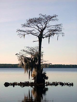
Singletary Lake, surrounded by Singletary Lake State Park in Bladen County, North Carolina in the United States, is one of a series of Carolina bay lakes that stretch from New Jersey to Florida along the Atlantic Coastal Plain. Recent work by the U.S. Geological Survey has interpreted the Carolina Bays as relict thermokarst lakes that formed several thousands of years ago when the climate was colder, drier, and windier. Thermokarst lakes develop by thawing of frozen ground (permafrost) and by subsequent modification by wind and water. Thus, this interpretation suggests that permafrost once extended as far south as the Carolina Bays during the last ice age and (or) previous ice ages. Singletary Lake is not fed by any stream, but relies entirely upon rain. The land beneath and surrounding the lake is mica-rich sandy clay and sand that is from the Upper Cretaceous era with a thin layer of Pleistocene deposits covering it. This land is lower than the surrounding land and drains very poorly, creating Singletary Lake.

The Carolina Sandhills National Wildlife Refuge is a 45,348-acre (183.52 km2) national wildlife refuge (NWR) located in Chesterfield County, South Carolina. The refuge is managed by the U.S. Fish and Wildlife Service from a headquarters located in McBee, South Carolina. The refuge is served by U.S. Highway 1, which passes through it.

Woods Bay State Park is a state park located near the town of Olanta in Florence County, South Carolina. The park contains some of the last remaining large Carolina Bays. Recent work by the U.S. Geological Survey has interpreted the Carolina Bays as relict thermokarst lakes that formed several thousands of years ago when the climate was colder, drier, and windier. Thermokarst lakes develop by thawing of frozen ground (permafrost) and by subsequent modification by wind and water. Thus, this interpretation suggests that permafrost once extended as far south as the Carolina Bays during the last ice age and (or) previous ice ages.

Little Pee Dee State Park is a state park located near the town of Dillon in Dillon County, South Carolina. The park land includes a part of a Carolina Bay and adjacent sand rim. Recent work by the U.S. Geological Survey has interpreted the Carolina Bays as relict thermokarst lakes that formed several thousands of years ago when the climate was colder, drier, and windier. Thermokarst lakes develop by thawing of frozen ground (permafrost) and by subsequent modification by wind and water. Thus, this interpretation suggests that permafrost once extended as far south as the Carolina Bays during the last ice age and (or) previous ice ages.
The geology of North Carolina includes ancient Proterozoic rocks belonging to the Grenville Province in the Blue Ridge. The region experienced igneous activity and the addition of new terranes and orogeny mountain building events throughout the Paleozoic, followed by the rifting of the Atlantic Ocean and the deposition of thick sediments in the Coastal Plain and offshore waters.

Sugarloaf Mountain near the town of Patrick is an unusual hill, known locally as "The Mountain," that towers a hundred feet above the surrounding terrain. This site is located within the Sand Hills State Forest, just off US highway 1, near Patrick, South Carolina in the Carolina Sandhills region of the U.S. Atlantic Coastal Plain province.