
Acton Town is a London Underground station in the south-west corner of Acton, West London, in the London Borough of Ealing, close to the border with the London Borough of Hounslow. The station is served by the District and Piccadilly lines and is in Travelcard Zone 3. On the District line, it is between Chiswick Park and Ealing Common stations, and on the Piccadilly line it is between Hammersmith and Ealing Common on the Uxbridge branch & South Ealing on the Heathrow branch. Acton Town station was opened as Mill Hill Park on 1 July 1879 by the District Railway. It remained as a terminus until on 1 May 1883 and 23 June 1903 the DR opened two branches from Acton Town to Hounslow Town and Park Royal & Twyford Abbey respectively. On 4 July 1932 the Piccadilly line was extended to Acton Town. District line services to both the Hounslow and Uxbridge branches were withdrawn completely on 9 and 10 October 1964 after which operations were provided by the Piccadilly line alone.
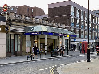
Bayswater is a London Underground station in the Bayswater area of the City of Westminster. The station is on the Circle and District lines, between Notting Hill Gate and Paddington stations and is in Travelcard Zone 1. It is less than 100 metres (330 ft) away from the Central line's Queensway station.

Edgware Road is a London Underground station on the Circle, District and Hammersmith & City lines, located on the corner of Chapel Street and Cabbell Street, within Travelcard zone 1. A separate station of the same name but served by the Bakerloo line is located about 150 metres away on the opposite side of Marylebone Road.
Hammersmith is a London Underground station in Hammersmith. It is on the District line between Barons Court and Ravenscourt Park, and on the Piccadilly line between Barons Court and Acton Town or Turnham Green at very early morning and late evening hours. The station is in Travelcard Zone 2.
Earl's Court tube station is a Grade II listed London Underground station in Earl's Court, London, on the District and Piccadilly lines. It is an important interchange for both lines and is situated in both Travelcard Zone 1 and Zone 2. The station has an eastern entrance on Earl's Court Road and a western entrance on Warwick Road. Another former entrance allowed passengers to enter the station from the other side of Warwick Road, via a ticket hall and subway leading to a concourse beneath the District line platforms. Earl's Court is a step-free tube station; the Earls Court Road entrance provides lift access between street and platform levels.

Gloucester Road is a London Underground station in Kensington, west London. The station entrance is located close to the junction of Gloucester Road and Cromwell Road. Close by are the Cromwell Hospital and Baden-Powell House.
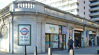
Temple is a London Underground station located at Victoria Embankment in the City of Westminster, close to its boundary with the City of London. It is on the Circle and District lines between Embankment and Blackfriars, and is in fare zone 1.

Barons Court is a London Underground station in West Kensington in the London Borough of Hammersmith and Fulham, Greater London. This station serves the District line and the Piccadilly line. Barons Court is between West Kensington and Hammersmith on the District line, and between Earl's Court and Hammersmith on the Piccadilly line and is in Travelcard Zone 2. East of the station, the Piccadilly line descends into tunnel towards Earl's Court and the District line continues in a cutting to West Kensington. The station is the last open air stop for eastbound trains on the Piccadilly line until Arnos Grove and has cross-platform interchange with the District line.

Bow Road is a London Underground station located on Bow Road in Bow, London, England. It is on the District and Hammersmith & City lines. The station is interlinked as an out of station interchange (OSI) with Bow Church station on the Docklands Light Railway which is about 300 m (980 ft) away via Bow Road. The two stations are classed as a single station for ticketing purposes as well as on tube maps but both are managed separately.

South Harrow is a London Underground station on the Uxbridge branch of the Piccadilly line. It is between Rayners Lane and Sudbury Hill stations. It is located on Northolt Road (A312). The station is in Travelcard Zone 5. There are several bus stands outside the station as well as overnight train stabling sidings.
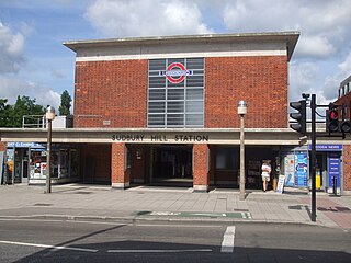
Sudbury Hill is a London Underground station on the Uxbridge branch of the Piccadilly line. The station is between Sudbury Town and South Harrow, and is in Travelcard Zone 4. It is located on Greenford Road (A4127) north of the junction with Whitton Avenue, on the border between the London Boroughs of Harrow and Ealing. The station is close to Sudbury Hill Harrow railway station.

Alperton is a London Underground station in Alperton, north-west London. It is on the Uxbridge branch of the Piccadilly line between Sudbury Town and Park Royal stations, in Travelcard Zone 4. It is located on Ealing Road (A4089), a short distance from the junction with Bridgewater Road (A4005), and is close to the Paddington branch of the Grand Union Canal.

Ealing Common is a London Underground station on the Uxbridge branch of the Piccadilly line and on the Ealing Broadway branch of the District line. Eastbound, the next station is Acton Town; westbound, the next station is North Ealing on the Piccadilly line and Ealing Broadway on the District line. Here, the District and Piccadilly lines share the same pair of tracks through the station – the only other example where a deep level line and a sub surface line share the same pair of tracks is further up the Uxbridge branch, where the Piccadilly line shares tracks with the Metropolitan line from Rayners Lane to Uxbridge. It is the only station west of Acton Town to be served by both the Piccadilly and District lines.
Latimer Road is a London Underground station in North Kensington, in the Royal Borough of Kensington and Chelsea. It is on the Circle and Hammersmith & City lines between Wood Lane and Ladbroke Grove stations and is in Travelcard Zone 2.
Wood Lane is a London Underground station in the White City area of west London, United Kingdom. It is on the Circle and Hammersmith & City lines, between Latimer Road and Shepherd's Bush Market stations, in Travelcard Zone 2.

Turnham Green is a London Underground station in Chiswick of the London Borough of Hounslow, west London. The station is served by the District and Piccadilly lines although currently Piccadilly line trains normally stop at the station only at the beginning and end of the day, running through non-stop at other times. To the east, District line trains stop at Stamford Brook and Piccadilly line trains stop at Hammersmith. To the west, District line trains run to either Chiswick Park or Gunnersbury and Piccadilly line trains stop at Acton Town. The station is in both Travelcard Zone 2 and Zone 3.

Chiswick Park is a London Underground station in the Acton Green district of Chiswick in West London. The station is served by the District line and is between Turnham Green and Acton Town stations. It is located at the junction of Bollo Lane and Acton Lane about 150 m north of Chiswick High Road (A315) and is in Travelcard Zone 3. The station is near Acton Green common. The Piccadilly line uses the inside tracks, but, as there are no platforms on these tracks, their trains cannot stop here.
North Ealing is a London Underground station on the Uxbridge branch of the Piccadilly line between Ealing Common and Park Royal. The station is located on Station Road, a short distance from the junction of Queen's Drive and Hanger Lane. It is in Travelcard Zone 3. West Acton station on the Central line is located about 550 metres to the east at the other end of Queen's Drive.

Ravenscourt Park is a London Underground station located in west Hammersmith, west London. The station is served by the District line and is between Hammersmith and Stamford Brook stations.

Stamford Brook is a London Underground station on the eastern edge of Chiswick in west London. The station is served by the District line and is between Ravenscourt Park and Turnham Green stations. The main entrance is located on Goldhawk Road (A402) with a secondary entrance on Prebend Gardens. It is in Travelcard Zone 2.


