
Council Bluffs is a city in and the county seat of Pottawattamie County, Iowa, United States. The city is the most populous in Southwest Iowa, and forms part of the Omaha (Nebr.) Metropolitan Area. It is located on the east bank of the Missouri River, across from the city of Omaha. Council Bluffs was known, until at least 1853, as Kanesville. It was the historic starting point of the Mormon Trail. Kanesville is also the northernmost anchor town of the other emigrant trails, since there was a steam powered boat to ferry their wagons, and cattle, across the Missouri River.

Martha's Vineyard is an island located south of Cape Cod in Massachusetts that is known for being an affluent summer colony. Martha's Vineyard includes the smaller Chappaquiddick Island, which is usually connected to the Vineyard, though storms and hurricanes have separated them, as in 2007. It is the 58th largest island in the United States, with a land area of 100 square miles (260 km2), and the third-largest on the East Coast of the United States, after Long Island and Mount Desert Island. Martha's Vineyard constitutes the bulk of Dukes County, Massachusetts, which also includes the Elizabeth Islands and the island of Nomans Land.

Butler County is a county located in the southeast Ozark Foothills Region in the U.S. state of Missouri. As of the 2010 Census, the county's population was 42,794. The largest city and county seat is Poplar Bluff. The county was officially organized from Wayne County on February 27, 1849, and is named after former U.S. Representative William O. Butler (D-Kentucky), who was also an unsuccessful candidate for Vice President of the United States. The first meeting in the Butler County Courthouse was held on June 18, 1849.

Oak Bluffs is a town located on the island of Martha's Vineyard in Dukes County, Massachusetts, United States. The population was 4,527 at the 2010 United States Census. It is one of the island's principal points of arrival for summer tourists, and is noted for its "gingerbread cottages" and other well-preserved mid- to late-nineteenth-century buildings.

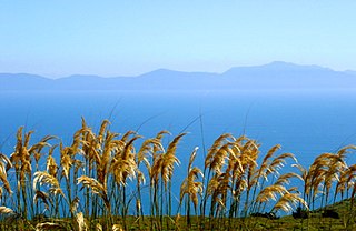
Bluff, previously known as Campbelltown and often referred to as "The Bluff", is a town and seaport in the Southland region, on the southern coast of the South Island of New Zealand. It is the southernmost town in mainland New Zealand and, despite Slope Point and Stewart Island being further south, Bluff is colloquially used to refer to the southern extremity of the country. According to the 2006 census, the resident population was 1,850, a decrease of 85 since 2001.

Alexander Island, which is also known as Alexander I Island, Alexander I Land, Alexander Land, Alexander I Archipelago, and Zemlja Alexandra I, is the largest island of Antarctica. It lies in the Bellingshausen Sea west of Palmer Land, Antarctic Peninsula from which it is separated by Marguerite Bay and George VI Sound. George VI Ice Shelf entirely fills George VI Sound and connects Alexander Island to Palmer Land. The island partly surrounds Wilkins Sound, which lies to its west. Alexander Island is about 390 kilometres (240 mi) long in a north-south direction, 80 kilometres (50 mi) wide in the north, and 240 kilometres (150 mi) wide in the south. Alexander Island is the second largest uninhabited island in the world, after Devon Island.
Foveaux Strait (Te Ara a Kiwa or Te Ara a Kewa separates Stewart Island/Rakiura, New Zealand's third largest island, from the South Island. According to a Maori legend, the strait was created by Kewa the obedient whale when traditional Maori ancestor Kiwa summoned the whale to create a waterway. Three large bays, Te Waewae Bay, Oreti Beach and Toetoes Bay, sweep along the strait's northern coast, which also hosts Bluff township and harbour. Across the strait lie the Solander Islands, Stewart Island/Rakiura, Dog Island and Ruapuke Island. The strait is about 130 km long, and it widens and deepens from east to west. The strait lies within the continental shelf area of New Zealand, and was probably dry land during the Pleistocene epoch.

Visokoi Island is an uninhabited island in the Traversay Islands group of the South Sandwich Islands. It was discovered in 1819 by a Russian expedition under Fabian Gottlieb von Bellingshausen, who named the island Visokoi ("high") because of its conspicuous height.

The Iowa Interstate Railroad is a Class II regional railroad operating in the central United States. The railroad is owned by Railroad Development Corporation of Pittsburgh, Pennsylvania.
The Bluff Branch, officially the Bluff Line since 2011, is a railway line in Southland, New Zealand that links Invercargill with the port of Bluff. One of the first railways in New Zealand, it opened in 1867 and is still operating. Presently, it essentially functions as an elongated industrial siding.

Fossil Bluff is a seasonal British aircraft refuelling station located on the northwest coast of Antarctica. In operation since 1961, its facilities provide fuel, storage, and ancillary support for British exploration and operations during the summer season, October through March. The site is adjacent to a natural, north-south travelling route along the George VI Ice Shelf.
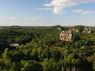
Mill Bluff State Park is a state park in west-central Wisconsin, United States. It is located in eastern Monroe and western Juneau counties, near the village of Camp Douglas. A unit of the Ice Age National Scientific Reserve, the park protects several prominent sandstone bluffs 80 feet (24 m) to 200 feet (61 m) high that formed as sea stacks 12,000 years ago in Glacial Lake Wisconsin. As a result, these bluffs are steep and angular, dissimilar to the rounded terrain more typical of the eastern half of the United States. The bluffs served as landmarks to both early pioneers and travelers today on Interstate 90/94, which passes through the park.

Black Bluff Island is an uninhabited island located in the Qikiqtaaluk Region, Nunavut, Canada. It is a Baffin Island offshore island in Hudson Strait. The closest community is Kimmirut, 17 km (11 mi) away.
Uugalautiit Island is an uninhabited island located in Qikiqtaaluk Region, Nunavut, Canada. It is a Baffin Island offshore island in Hudson Strait. The closest community is Kimmirut, 6.2 km (3.9 mi) away.
Beacon Island is an uninhabited island located in the Qikiqtaaluk Region, Nunavut, Canada. It lies in the Nascopie Reefs, just east of Dorset Island, itself a Baffin Island offshore island in Hudson Strait. The closest community is Kimmirut, 20.9 km (13.0 mi) away.
Rabbit Island is an uninhabited island located in Qikiqtaaluk Region, Nunavut, Canada. It is a Baffin Island offshore island in Hudson Strait. The closest community is Kimmirut.

Oaks Bottom Wildlife Refuge is a city park of about 141 acres (57 ha) in southeast Portland, in the U.S. state of Oregon. Located in a floodplain along the east bank of the Willamette River near Sellwood, the park is known for attracting a wide variety of birds. In 1988, the park was named Portland's first wildlife refuge, and in 2004, it was designated the city's first migratory bird park.

The Swallow Bluff Island Mounds (40HR16) is a Mississippian culture archaeological site located near Saltillo on Swallow Bluff Island in the Tennessee River in Hardin County, Tennessee.

The High Point-Half Moon Bluff Historic District, on Cumberland Island near St. Marys, Georgia is a historic district which was listed on the National Register of Historic Places in 1978.


