Related Research Articles
Glencoe was a place name used by Scottish immigrants to name several places in the world. Glencoe may also refer to:
Strathcona is a 19th-century variation of "Glen Coe", a river valley in Scotland. The word was invented for use in the title Baron Strathcona and Mount Royal, first used for Donald Smith, a Canadian railway financier, in order to avoid association with the Massacre of Glencoe of 1692.

Russell Island is an uninhabited island of the Canadian Arctic Archipelago in the Qikiqtaaluk Region of Nunavut, Canada. It is located in the Parry Channel, separated from the northern tip of Prince of Wales Island by the narrow Baring Channel. The western third of the island is separated from the other two thirds by a narrow lake and its outlet. At the northern end of the lake there is an isthmus just 1.1 km (0.68 mi) wide and this joins the two parts of the island. With a total area of 940 km2 (360 sq mi), it is the largest island offshore of Prince of Wales Island.

Nunavut is the newest, largest, and most northerly territory of Canada. It was separated officially from the Northwest Territories on April 1, 1999, via the Nunavut Act and the Nunavut Land Claims Agreement Act, though the boundaries had been drawn in 1993. The creation of Nunavut resulted in the first major change to Canada's political map since incorporating the province of Newfoundland in 1949.

The uninhabited Hamilton Island is located in Qikiqtaaluk Region, Nunavut, Canada. It is a member of the Canadian Arctic Archipelago and lies in the Parry Channel, north of Russell Island, and southwest of Young Island.
Young Island is an uninhabited member of the Canadian Arctic Archipelago in the territory of Nunavut. It lies in the Parry Channel, southwest of Lowther Island, and northeast of Hamilton Island.
Lock Island is a member of the Canadian Arctic Archipelago in the territory of Nunavut. It lies in Peel Sound across the mouth of Browne Bay, between northeastern Prince of Wales Island and northwestern Somerset Island. Vivian Island lies to the southeast, and Binstead Island to the northeast.
Barth Island an uninhabited island in the Qikiqtaaluk Region of Nunavut, Canada. It is located in Peel Sound, south of Somerset Island's Four Rivers Bay, and the equally small Otrick Island. Prince of Wales Island is to the west.

Davids Island is a member of the Canadian Arctic Archipelago in the Qikiqtaaluk Region, Nunavut. It is an irregularly shaped Baffin Island offshore island, located in Admiralty Inlet, at the mouth of Fleming Inlet and Fabricius Fiord.
The Wollaston Islands are uninhabited members of the Canadian Arctic Archipelago in the territory of Nunavut. Located on the east side of the mouth of Navy Board Inlet, the island group is closer to Bylot Island than to Baffin Island.
Okolli Island is one of the Canadian arctic islands located in Hudson Strait, Nunavut, Canada. It is a Baffin Island offshore island in Qikiqtaaluk Region. The island is 4.5 miles (7.2 km) long and 1.5 miles (2.4 km) wide. The elevation is 351 feet (107 m) above sea level.
The Sheer Islands are Canadian arctic islands that are located in Qikiqtaaluk Region, Nunavut, Canada. They are a Baffin Island offshore island group in Hudson Strait. The islands are situated approximately 1 mi (1.6 km) north of Cape Tanfield and form part of the north side of Itivirk Bay.
Hector Island is an uninhabited Canadian arctic island located in Hudson Strait. It is a Baffin Island offshore island in Nunavut's Qikiqtaaluk Region.
Igloolik Island is a small island in the Qikiqtaaluk Region of Nunavut, Canada. It is located in the Foxe Basin, very close to the Melville Peninsula, and it is often thought to be a part of the peninsula. It forms part of the Canadian Arctic Archipelago.
Qaqaluit Island is one of eastern Baffin Island's small, offshore, uninhabited islands, located in the Canadian Arctic Archipelago in Qikiqtaaluk Region, Nunavut. Along with Padloping Island and Durban Island, it is situated off Cumberland Peninsula within Davis Strait's Merchants Bay.
Round Island is an uninhabited island in the Qikiqtaaluk Region of Nunavut, Canada. It is located across the mouth of Coutts Inlet in Baffin Bay off the northeastern coast of Baffin Island. Nova Zembla Island is 7.4 km (4.6 mi) to the northwest.
Low Island is one of the many uninhabited Canadian arctic islands in Qikiqtaaluk Region, Nunavut. It is a Baffin Island offshore island located in Frobisher Bay just off the Bartlett Narrows, southeast of the capital city of Iqaluit. Other islands in the immediate vicinity include Culbertson Island, Mark Island, McAllister Island, Mitchell Island, and Precipice Island.
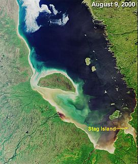
Stag Island is an uninhabited island in the southern part of James Bay, in the Qikiqtaaluk Region of Nunavut, Canada. Located at 51°39′01″N79°04′28″W, it is the southernmost island and point of land in Nunavut.
References
- ↑ "Geographic features & Photographs around Glencoe Island, in Nunavut, Canada". travelingluck.com. Retrieved 2009-02-24.
- Glencoe Island, at Atlas of Canada
| This Qikiqtaaluk Region, Nunavut location article is a stub. You can help Wikipedia by expanding it. |