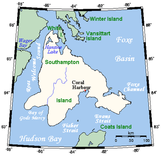
Southampton Island is a large island at the entrance to Hudson Bay at Foxe Basin. One of the larger members of the Canadian Arctic Archipelago, Southampton Island is part of the Kivalliq Region in Nunavut, Canada. The area of the island is stated as 41,214 km2 (15,913 sq mi) by Statistics Canada. It is the 34th largest island in the world and Canada's ninth largest island. The only settlement on Southampton Island is Coral Harbour, called in Inuktitut Salliq.

Bylot Island lies off the northern end of Baffin Island in Nunavut Territory, Canada. Eclipse Sound to the southeast and Navy Board Inlet to the southwest separate it from Baffin Island. Parry Channel lies to its northwest. At 11,067 km2 (4,273 sq mi) it is ranked 71st largest island in the world and Canada's 17th largest island. The island measures 180 km (110 mi) east to west and 110 km (68 mi) north to south and is one of the largest uninhabited islands in the world. While there are no permanent settlements on this Canadian Arctic island, Inuit from Pond Inlet and elsewhere regularly travel to Bylot Island. An Inuit seasonal hunting camp is located southwest of Cape Graham Moore.

Akpatok Island is one of the uninhabited Canadian Arctic islands in the Qikiqtaaluk Region of Nunavut, Canada. It is the largest island in Ungava Bay on the northern coast of Quebec. The island is named for the Akpat, the thick-billed murre, which live on ledges along the limestone cliffs surrounding the island.

Sirmilik National Park is a national park located in Qikiqtaaluk, Nunavut, Canada, established in 1999. Situated within the Arctic Cordillera, the park is composed of three areas: most of Bylot Island with the exception for a few areas that are Inuit-owned lands, Oliver Sound, and Baffin Island's Borden Peninsula. Much of the park is bordered by water.

Coburg Island is an uninhabited island in Qikiqtaaluk, Nunavut, Canada. It is one of the members of Queen Elizabeth Islands located in Baffin Bay's Lady Ann Strait. It is separated from Ellesmere Island by Glacier Strait; Devon Island is to the south.

The Great Plain of the Koukdjuak is located in the Qikiqtaaluk Region, Nunavut within the Canadian Arctic. It is the namesake of the Koukdjuak River in western Baffin Island on the southeastern coast of Foxe Basin. It stretches from Cory Bay to Hantzsch Bay, and then inland.
The Twin Islands are similarly shaped Arctic islands in the Qikiqtaaluk Region of Nunavut, Canada. They are located in central James Bay, 56 km (35 mi) north east of Akimiski Island, and 58 km (36 mi) west of Quebec. The group includes North Twin and South Twin islands.
Berlinguet Inlet is a body of water within the Qikiqtaaluk Region of Nunavut, Canada. It runs west-east at Admiralty Inlet's southern end, separated from Berlinguet Bay, which opens into the Gulf of Boothia, by a 1.5 km (0.93 mi) isthmus. Baffin Island's Brodeur Peninsula is to the north.
Scott Inlet is a body of water in the Qikiqtaaluk Region of Nunavut, Canada. It is an arm of Baffin Bay. Scott Island lies in its middle. At its south end, it splits into Clark and Gibbs Fiords. The Inuit community of Clyde River is approximately 120 km (75 mi) to the southeast.

Awrey Island is an uninhabited island located in Hudson Bay, within the Qikiqtaaluk Region of Nunavut, Canada. It is situated 1 km (0.62 mi) east of Mansel Island. Quebec's Ungava Peninsula is to the east.

Baillarge Bay is an Arctic waterway in the Qikiqtaaluk Region, Nunavut, Canada. It is the second waterway to press eastward from Admiralty Inlet into Baffin Island. The southern point of its mouth is named Ship Point.
Cape Liddon is an uninhabited headland on Devon Island in the Qikiqtaaluk Region of Nunavut, Canada. It is located on the southwestern coast of the island at Radstock Bay.

Cape Graham Moore is an uninhabited headland on Bylot Island in the Qikiqtaaluk Region of Nunavut, Canada. It is located at the island's southeastern tip protruding into Lancaster Sound. The community of Pond Inlet is 70 km (43 mi) to the southwest.
Reid Bay is an Arctic waterway in the Qikiqtaaluk Region, Nunavut, Canada. It is located in Davis Strait off Baffin Island's Cumberland Sound.
Fraser Island is an uninhabited island in the Qikiqtaaluk Region of Nunavut, Canada. It is located at the mouth of Hudson Bay off Nottingham Island's northwestern tip. The closest community is the Inuit hamlet of Cape Dorset, 120 km (75 mi) to the northeast on Baffin Island.
Hantzsch Island is an uninhabited island in the Qikiqtaaluk Region of Nunavut, Canada. It is located in Frobisher Bay off the southern tip of Baffin Island's Meta Incognita Peninsula and the northeastern tip of Edgell Island. The closest community is the Inuit hamlet of Sanikiluaq, 800 km (500 mi) to the west on Flaherty Island.
The uninhabited Payne Islands are an archipelago, members of the Canadian Arctic Archipelago and the Ungava Bay Archipelago, in the Qikiqtaaluk Region of Nunavut, Canada. They are located in Payne Bay, a waterway in western Ungava Bay, just east of the Arnaud River and the community of Kangirsuk on Quebec's Ungava Peninsula.

The Akimiski Island Migratory Bird Sanctuary is a migratory bird sanctuary in Qikiqtaaluk, Nunavut, Canada. It is located on Akimiski Island within James Bay. The sanctuary, established by the Canadian government on 1 January 1941, has federal conservation status. Taking up the eastern two-thirds of the island, it is 3,367 km2 (1,300 sq mi) in overall size, including a 1,664 km2 (642 sq mi) marine area. It includes marine, intertidal, and subtidal components and is rated Category IV by the International Union for Conservation of Nature.
Nirjutiqavvik National Wildlife Area is a National Wildlife Area on Coburg Island within Qikiqtaaluk, Nunavut, Canada. It is located in Baffin Bay's Lady Ann Strait between Ellesmere Island, to the north, and Devon Island to the south. The NWA includes Coburg Island and its surrounding marine area.


