
Newark Northgate railway station is on the East Coast Main Line serving the market town of Newark-on-Trent, Nottinghamshire, England. It is 120 miles 8 chains (193.3 km) down the line from London King's Cross and is situated on the main line between Grantham to the south and Retford to the north. The station is Grade II listed.

Peterborough railway station serves the cathedral city of Peterborough, Cambridgeshire, England. It is sited 76 miles 29 chains (122.9 km) north of London King's Cross. The station is a major interchange serving both the north–south East Coast Main Line, as well as long-distance and local east–west services. The station is managed by London North Eastern Railway. Ticket gates came into use at the station in 2012.
Harling Road railway station is on the Breckland line in the east of England, serving the villages of Larling, Roudham and East Harling, Norfolk. The line runs between Cambridge in the west and Norwich in the east.

Scunthorpe railway station serves the town of Scunthorpe in North Lincolnshire, England. The station is located a short walk from the town centre, on Station Road.

Mirfield railway station serves the town of Mirfield in West Yorkshire, England. It lies on the Huddersfield Line and is managed by Northern and also receives services by Grand Central and also TransPennine Express. The station is 4 miles (6 km) north east from Huddersfield.

Ravensthorpe railway station serves the Ravensthorpe suburb of Dewsbury in West Yorkshire, England. It is situated on the Huddersfield line between Leeds and Manchester, 8 miles (13 km) north east of Huddersfield.

Slaithwaite railway station serves the town of Slaithwaite, West Yorkshire, England. The station is 4 miles (6 km) west of Huddersfield railway station on the Huddersfield Line between Huddersfield and Manchester Victoria.
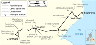
The Grantham–Skegness line, promoted originally as the Poacher Line, runs for 55 miles (89 km) between Grantham and Skegness in Lincolnshire, England. Trains on this route generally operate hourly from Nottingham to Skegness via the Nottingham to Grantham Line, with additional slower stopping services at peak times. The line is operated by East Midlands Railway, using Class 170 Turbostar and Class 158 Express Sprinter diesel multiple units.

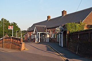
Heckington railway station is located in the village of Heckington in Lincolnshire, England. The old station building houses the Heckington Station Railway and Heritage Museum.

Swineshead railway station serves the village of Swineshead in Lincolnshire, England. Although named Swineshead, the station is, in reality, located in the hamlet of Swineshead Bridge some miles north of Swineshead. The line was opened by the Boston, Sleaford and Midland Counties Railway.

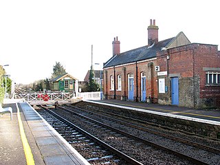
Boston railway station serves the town of Boston in Lincolnshire, England. It is a stop on the Poacher Line, which connects Grantham with Skegness. The station is owned by Network Rail and managed by East Midlands Railway, who provide all rail services.

Thorpe Culvert railway station serves the village of Thorpe St Peter in Lincolnshire, England. It is situated 7 miles (11 km) from Skegness and 16.75 miles (27 km) from Boston.

Spalding railway station serves the town of Spalding, Lincolnshire, England. It lies on the Peterborough–Lincoln line.

Ruskington railway station serves the village of Ruskington in Lincolnshire, England. It opened in 1882 as part of the Great Northern and Great Eastern Joint Railway between Sleaford and Lincoln Central. It closed in 1961 but was reopened in 1975.

Metheringham railway station serves the village of Metheringham in Lincolnshire, England. It lies on the Peterborough–Lincoln line. It is owned by Network Rail and managed by East Midlands Railway, which provides all its rail services.

Longton railway station is a railway station in England at Longton, Stoke-on-Trent. The station is served by trains on the Crewe to Derby Line which is also a community rail line known as the North Staffordshire line. The station is owned by Network Rail and managed by East Midlands Railway. The full range of tickets for travel are purchased from the guard on the train at no extra cost.
Olton railway station serves the Olton area of the town of Solihull, in the West Midlands of England. The station is operated by West Midlands Trains. The entrance seen in the centre where the station's booking office is located leads into a tunnel which runs under the tracks providing an access staircase and lift to the island platform. The station also has a car park and bicycle racks.
Tyseley railway station serves the district of Tyseley in Birmingham, West Midlands, England. It is at the junction of the lines linking Birmingham with Leamington Spa and Stratford-upon-Avon.

Lea Hall railway station is situated in the Lea Hall area east of the city of Birmingham, in the West Midlands of England. It has two platforms, one each side of the two running lines, with no points or sidings. The ticket office is on a bridge over the tracks, which are a little below street level. The station, and all trains serving it, are operated by West Midlands Trains. Ramps have been added to permit easy disabled access to both platforms.
Reigate railway station serves the town of Reigate, Surrey, England, on the North Downs Line. It is 24 miles 27 chains measured from London Charing Cross via Redhill. The station is managed by Southern.
