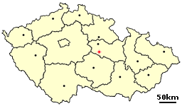
České Lhotice is very small village in the Pardubice Region of the Czech Republic. It has around 100 inhabitants.
Farasan is the largest town of the Farasan Islands, in the Red Sea. Islands are a part of the Jizan Province, far south-western part of Saudi Arabia. It is located on the Farasan Island at around 16°42′8″N42°7′6″E.

Konská is a village and municipality in Liptovský Mikuláš District in the Žilina Region of northern Slovakia.
Bayan-Ovoo is a sum (district) of Ömnögovi Province in southern Mongolia.

Wysoka Wieś is a village in the administrative district of Gmina Tuchola, within Tuchola County, Kuyavian-Pomeranian Voivodeship, in north-central Poland. It lies approximately 5 kilometres (3 mi) south of Tuchola and 51 km (32 mi) north of Bydgoszcz.
Nowosiółki is a village in the administrative district of Gmina Hrubieszów, within Hrubieszów County, Lublin Voivodeship, in eastern Poland, close to the border with Ukraine. It lies approximately 5 kilometres (3 mi) north-west of Hrubieszów and 100 km (62 mi) south-east of the regional capital Lublin.
Płonka-Strumianka is a village in the administrative district of Gmina Łapy, within Białystok County, Podlaskie Voivodeship, in north-eastern Poland.
Wyrębów is a village in the administrative district of Gmina Zadzim, within Poddębice County, Łódź Voivodeship, in central Poland. It lies approximately 8 kilometres (5 mi) north of Zadzim, 10 km (6 mi) south-west of Poddębice, and 42 km (26 mi) west of the regional capital Łódź.
Łopatki-Kolonia is a village in the administrative district of Gmina Wąwolnica, within Puławy County, Lublin Voivodeship, in eastern Poland.
Kamionka is a village in the administrative district of Gmina Glinojeck, within Ciechanów County, Masovian Voivodeship, in east-central Poland.
Górzno is a village in Garwolin County, Masovian Voivodeship, in east-central Poland. It is the seat of the gmina called Gmina Górzno. It lies approximately 9 kilometres (6 mi) south-east of Garwolin and 64 km (40 mi) south-east of Warsaw.
Skłody-Stachy is a village in the administrative district of Gmina Zaręby Kościelne, within Ostrów Mazowiecka County, Masovian Voivodeship, in east-central Poland.
Nowe Gralewo is a village in the administrative district of Gmina Raciąż, within Płońsk County, Masovian Voivodeship, in east-central Poland. It lies approximately 8 kilometres (5 mi) south of Raciąż, 21 km (13 mi) north-west of Płońsk, and 82 km (51 mi) north-west of Warsaw.
Stare Gralewo is a village in the administrative district of Gmina Raciąż, within Płońsk County, Masovian Voivodeship, in east-central Poland. It lies approximately 8 kilometres (5 mi) south of Raciąż, 21 km (13 mi) north-west of Płońsk, and 82 km (51 mi) north-west of Warsaw.
Łomów is a village in the administrative district of Gmina Zagórów, within Słupca County, Greater Poland Voivodeship, in west-central Poland.

Wręczyca Wielka is a village in Kłobuck County, Silesian Voivodeship, in southern Poland. It is the seat of the gmina called Gmina Wręczyca Wielka. It lies approximately 8 kilometres (5 mi) south of Kłobuck and 67 km (42 mi) north of the regional capital Katowice.

Kalâat el-Andalous is a town and commune in the Ariana Governorate, Tunisia. It is located 30 miles north of Tunis. As of 2004 it had a total population of 15,313.

Gornji Striževac is a village in the municipality of Babušnica, Serbia. According to the 2002 census, the village has a population of 154 people.

Bukova Glava is a village in the municipality of Leskovac, Serbia. According to the 2002 census, the village has a population of 295 people.

Nézsa is a village in Nógrád County, Hungary with 1,093 inhabitants (2014).


