List of Sierra Nevada topics

Last updated

Yosemite Valley Tunnel View, Yosemite Valley, Yosemite NP - Diliff.jpg
Yosemite Valley

This list is about the Sierra Nevada of California, United States.

Contents

Principal mountains

Mount Whitney Mount Whitney 2003-03-25.jpg
Mount Whitney

List of mountains over 14,000 ft (4250 m) with 300 ft (90 m) of prominence: [1]

Other notable peaks:

Subranges

Counties in the Sierra

Sonora Peak, highest point in Alpine County 20040626-1033-0476-SonoraPass-CA.jpg
Sonora Peak, highest point in Alpine County

The Carson Range (a spur of the Sierra) extends into Nevada:

Principal rivers

The headwaters of the San Joaquin River San Joaquin River headwaters 2.jpg
The headwaters of the San Joaquin River

Prominent Lakes

Mono Lake as seen from Mount Dana. Mono Lake from Mount Dana (1).jpg
Mono Lake as seen from Mount Dana.

Other natural features

Hetch Hetchy Valley Hetch Hetchy May 2011 001.jpg
Hetch Hetchy Valley

National parks and monuments

Devils Postpile Devils Postpile National Monument near Mammoth Lakes.jpg
Devils Postpile

North to south:

Eastern side of the Sierra:

National forests

Wilderness areas

Mount Ritter and Banner Peak in the Ansel Adams Wilderness Ritter and banner.jpg
Mount Ritter and Banner Peak in the Ansel Adams Wilderness

A total of over 3,726,000 acres (15,080 km2) in 26 separate areas [2]

State Parks

California

Bodie State Historic Park Bodie Ghost Town Storm.jpg
Bodie State Historic Park

Nevada

Trails and routes

Giant sequoia

General Sherman Tree General Sherman tree looking up.jpg
General Sherman Tree

Mountain passes

Fires

Rim Fire The Rim Fire in the Stanislaus National Forest near in California began on Aug. 17, 2013-0004.jpg
Rim Fire
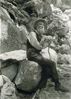
John Muir John Muir Cane.JPG
John Muir

Relevant list articles

See also

Related Research Articles

<span class="mw-page-title-main">Yosemite National Park</span> National park in California, United States

Yosemite National Park is a national park in California. It is bordered on the southeast by Sierra National Forest and on the northwest by Stanislaus National Forest. The park is managed by the National Park Service and covers 759,620 acres in four counties – centered in Tuolumne and Mariposa, extending north and east to Mono and south to Madera. Designated a World Heritage Site in 1984, Yosemite is internationally recognized for its granite cliffs, waterfalls, clear streams, giant sequoia groves, lakes, mountains, meadows, glaciers, and biological diversity. Almost 95 percent of the park is designated wilderness. Yosemite is one of the largest and least fragmented habitat blocks in the Sierra Nevada.

<span class="mw-page-title-main">Sierra Nevada</span> Mountain range in the Western United States

The Sierra Nevada is a mountain range in the Western United States, between the Central Valley of California and the Great Basin. The vast majority of the range lies in the state of California, although the Carson Range spur lies primarily in Nevada. The Sierra Nevada is part of the American Cordillera, an almost continuous chain of mountain ranges that forms the western "backbone" of the Americas.

<span class="mw-page-title-main">Geography of California</span> Overview of the geography of California

California is a U.S. state on the western coast of North America. Covering an area of 163,696 sq mi (423,970 km2), California is among the most geographically diverse states. The Sierra Nevada, the fertile farmlands of the Central Valley, and the arid Mojave Desert of the south are some of the major geographic features of this U.S. state. It is home to some of the world's most exceptional trees: the tallest, most massive, and oldest. It is also home to both the highest and lowest points in the 48 contiguous states. The state is generally divided into Northern and Southern California, although the boundary between the two is not well defined. San Francisco is decidedly a Northern California city and Los Angeles likewise a Southern California one, but areas in between do not often share their confidence in geographic identity. The US Geological Survey defines the geographic center of California about 7.1 miles driving distance from the United States Forest Service office in the Northern Californian city of North Fork, California.

<span class="mw-page-title-main">John Muir Trail</span> Trail in the Sierra Nevada mountains of California

The John Muir Trail (JMT) is a long-distance trail in the Sierra Nevada mountain range of California, passing through Yosemite, Kings Canyon and Sequoia National Parks. It is named after John Muir, a naturalist.

<span class="mw-page-title-main">Tuolumne Meadows</span> Meadow in Yosemite National Park, US

Tuolumne Meadows is a gentle, dome-studded, sub-alpine meadow area along the Tuolumne River in the eastern section of Yosemite National Park in the United States. Its approximate location is 37°52.5′N119°21′W. Its approximate elevation is 8,619 feet (2,627 m). The term Tuolumne Meadows is also often used to describe a large portion of the Yosemite high country around the meadows, especially in context of rock climbing.

<span class="mw-page-title-main">Kings Canyon National Park</span> National park in California, United States

Kings Canyon National Park is an American national park in the southern Sierra Nevada, in Fresno and Tulare Counties, California. Originally established in 1890 as General Grant National Park, the park was greatly expanded and renamed on March 4, 1940. The park's namesake, Kings Canyon, is a rugged glacier-carved valley more than a mile (1,600 m) deep. Other natural features include multiple 14,000-foot (4,300 m) peaks, high mountain meadows, swift-flowing rivers, and some of the world's largest stands of giant sequoia trees. Kings Canyon is north of and contiguous with Sequoia National Park, and both parks are jointly administered by the National Park Service as the Sequoia and Kings Canyon National Parks.

<span class="mw-page-title-main">Calaveras Big Trees State Park</span> State park in California, US

Calaveras Big Trees State Park is a state park of California, United States, preserving two groves of giant sequoia trees. It is located 4 miles (6.4 km) northeast of Arnold, California in the middle elevations of the Sierra Nevada. It has been a major tourist attraction since 1852, when the existence of the trees was first widely reported, and is considered the longest continuously operated tourist facility in California.

<span class="mw-page-title-main">Tioga Pass</span> Mountain pass in the American state of California

Tioga Pass is a mountain pass in the Sierra Nevada mountain range of California. State Route 120 runs through it, and serves as the eastern entry point for Yosemite National Park, at the Tioga Pass Entrance Station. It is the highest elevation highway pass in California and in the Sierra Nevada at an elevation of 9,945 ft (3,031 m). Mount Dana is to the east of the pass, and Gaylor Peak to the west.

<span class="mw-page-title-main">Sierra National Forest</span> National forest in California, United States

Sierra National Forest is a U.S. national forest located on the western slope of central Sierra Nevada in Central California and bounded on the northwest by Yosemite National Park and the south by Kings Canyon National Park. The forest is known for its mountain scenery and beautiful lakes. Forest headquarters are located in Clovis, California. There are local ranger district offices in North Fork and Prather.

<span class="mw-page-title-main">Stanislaus National Forest</span> U.S. National Forest designated in 1976

Stanislaus National Forest is a U.S. National Forest which manages 898,099 acres of land in four counties in the Sierra Nevada in Northern California. It was established on February 22, 1897, making it one of the oldest national forests. It was named after the Stanislaus River.

<span class="mw-page-title-main">Bibliography of the Sierra Nevada</span>

The following is a bibliography of the Sierra Nevada of California, United States, including books on recreation, natural history, and human history.

<span class="mw-page-title-main">Inyo National Forest</span> National forest in California and Nevada, United States

Inyo National Forest is a United States National Forest covering parts of the eastern Sierra Nevada of California and the White Mountains of California and Nevada. The forest hosts several superlatives, including Mount Whitney, the highest point in the contiguous United States; Boundary Peak, the highest point in Nevada; and the Ancient Bristlecone Pine Forest, which protects the oldest living trees in the world. The forest, encompassing much of the Owens Valley, was established by Theodore Roosevelt as a way of sectioning off land to accommodate the Los Angeles Aqueduct project in 1907, making the Inyo National Forest one of the least wooded forests in the U.S. National Forest system.

<span class="mw-page-title-main">Tahoe National Forest</span> U.S. National Forest in California

Tahoe National Forest is a United States National Forest located in California, northwest of Lake Tahoe. It includes the 8,587-foot (2,617 m) peak of Sierra Buttes, near Sierra City, which has views of Mount Lassen and Mount Shasta. It is located in parts of six counties: Sierra, Placer, Nevada, Yuba, Plumas and El Dorado. The forest has a total area of 871,495 acres. Its headquarters is in Nevada City, California. There are local ranger district offices in Camptonville, Foresthill, Sierraville and Truckee.

<span class="mw-page-title-main">High Sierra Trail</span> Long-distance hiking trail in the United States

The High Sierra Trail (HST) is a hiking trail in Sequoia National Park, California. The trail crosses the Sierra Nevada from west to east. According to the Yosemite Decimal System, the HST is a Class 1/Class 2 trail, which means simple scrambling, with the possibility of occasional use of the hands for balance.

<span class="mw-page-title-main">Dardanelles and Freel Roadless Areas</span>

The Dardanelles and Freel Roadless Areas are located 7 miles (11 km) and 3 miles (4.8 km), respectively, south of Lake Tahoe, California, and both are managed by the Lake Tahoe Basin Management Unit of the US Forest Service.These areas are contiguous, separated only by the corridor of highway 89. The historic Hawley Grade, an immigrant wagon road, now a hiking trail, is within the Dardanelles Roadless Area, as well as the watershed of Lake Tahoe's largest inflow, the Upper Truckee River.

<span class="mw-page-title-main">Tahoe–Yosemite Trail</span>

The Tahoe–Yosemite Trail (TYT) is a long-distance trail in the Sierra Nevada mountain range of California. The trail courses 186 miles (299 km) from Meeks Bay at Lake Tahoe to Tuolumne Meadows in Yosemite National Park. The trail is a foot and equestrian path that passes through the Desolation, Mokelumne, Carson-Iceberg, Emigrant, and Yosemite Wilderness Areas and the Meiss Country (Dardanelles) Roadless Area.

The protected areas of the Sierra Nevada, a major mountain range located in the U.S. states of California and Nevada, are numerous and highly diverse. Like the mountain range itself, these areas span hundreds of miles along the length of the range, and over 14,000 feet of elevation from the lowest foothills to the summit of Mount Whitney.

<span class="mw-page-title-main">Gaylor Peak</span> Mountain summit in California

Gaylor Peak is an 11,004-foot-elevation (3,354 meter) mountain summit located on the crest of the Sierra Nevada mountain range in northern California, United States. The peak is situated on the common boundary shared by Yosemite National Park with Inyo National Forest, as well as the border shared by Mono County with Tuolumne County. It rises immediately above the park's Tioga Pass entrance station and Tioga Lake. Topographic relief is significant as the summit rises approximately 1,400 feet above the lake in one-half mile (0.80 km). The peak is a popular hiking destination on summer weekends due to easy access via the two-mile Gaylor Lakes Trail from State Route 120 which traverses the east base of the peak.

<span class="mw-page-title-main">Mather Pass</span> Mountain pass in the Sierra Nevada, California

Mather Pass is a high mountain pass in the U.S. state of California's Sierra Nevada mountain range. It lies within far eastern Fresno County, inside Kings Canyon National Park and the Sequoia-Kings Canyon Wilderness. The pass lies at an elevation of 12,068 feet, separating Palisade Basin to the north and Upper Basin to the south.

<span class="mw-page-title-main">Pinchot Pass</span> Mountain pass in the Sierra Nevada, California

Pinchot Pass is a high mountain pass in the Sierra Nevada mountain range of California, in the United States. It lies within far eastern Fresno County, inside Kings Canyon National Park and the Sequoia-Kings Canyon Wilderness.

References

  1. "California 13,500-foot Peaks". Peakbagger.com.
  2. "Wilderness Areas in the Sierra Nevada". Archived from the original on 2017-09-27. Retrieved 2017-09-27.