Most of the lakes of Korea are artificial reservoirs, due to the country's rugged topography. Natural lakes include the crater lakes atop Baekdusan and Hallasan, the Upo wetland, and various lagoons along the coast of the Sea of Japan.

South Korea is located in East Asia, on the southern portion of the Korean Peninsula located out from the far east of the Asian landmass. The only country with a land border to South Korea is North Korea, lying to the north with 238 kilometres (148 mi) of the border running along the Korean Demilitarized Zone. South Korea is mostly surrounded by water and has 2,413 kilometres (1,499 mi) of coast line along three seas; to the west is the Yellow Sea, to the south is the East China Sea, and to the east is the Sea of Japan. Geographically, South Korea's landmass is approximately 100,032 square kilometres (38,623 sq mi). 290 square kilometres (110 sq mi) of South Korea are occupied by water. The approximate coordinates are 37° North, 128° East.

A swamp is a forested wetland. Swamps are considered to be transition zones because both land and water play a role in creating this environment. Swamps vary in size and are located all around the world. The water of a swamp may be fresh water, brackish water, or seawater. Freshwater swamps form along large rivers or lakes where they are critically dependent upon rainwater and seasonal flooding to maintain natural water level fluctuations. Saltwater swamps are found along tropical and subtropical coastlines. Some swamps have hammocks, or dry-land protrusions, covered by aquatic vegetation, or vegetation that tolerates periodic inundation or soil saturation. The two main types of swamp are "true" or swamp forests and "transitional" or shrub swamps. In the boreal regions of Canada, the word swamp is colloquially used for what is more formally termed a bog, fen, or muskeg. Some of the world's largest swamps are found along major rivers such as the Amazon, the Mississippi, and the Congo.

A marsh is a wetland that is dominated by herbaceous rather than woody plant species. Marshes can often be found at the edges of lakes and streams, where they form a transition between the aquatic and terrestrial ecosystems. They are often dominated by grasses, rushes or reeds. If woody plants are present they tend to be low-growing shrubs, and the marsh is sometimes called a carr. This form of vegetation is what differentiates marshes from other types of wetland such as swamps, which are dominated by trees, and mires, which are wetlands that have accumulated deposits of acidic peat.

South Gyeongsang Province is a province in the southeast of South Korea. The provincial capital is at Changwon. It is adjacent to the major metropolitan center and port of Busan. The UNESCO World Heritage Site Haeinsa, a Buddhist temple that houses the Tripitaka Koreana and tourist attraction, is located in this province. Automobile and petrochemical factories are largely concentrated along the southern part of the province, extending from Ulsan through Busan, Changwon, and Jinju.

Land reclamation, usually known as reclamation, and also known as land fill, is the process of creating new land from oceans, seas, riverbeds or lake beds. The land reclaimed is known as reclamation ground or land fill.

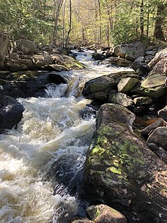
A body of water or waterbody is any significant accumulation of water on the surface of Earth or another planet. The term most often refers to oceans, seas, and lakes, but it includes smaller pools of water such as ponds, wetlands, or more rarely, puddles. A body of water does not have to be still or contained; rivers, streams, canals, and other geographical features where water moves from one place to another are also considered bodies of water.
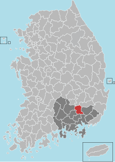
Changnyeong County is a county in South Gyeongsang Province, South Korea.

The Nakdonggang River or Nakdonggang is the longest river in South Korea, and passes through major cities such as Daegu and Busan. It takes its name from its role as the eastern border of the Gaya confederacy during Korea's Three Kingdoms Era.
Upo Wetland is a complex of natural wetlands located in Changnyeong County, South Korea, near the Nakdong River. It is located in portions of Yueo-myeon, Ibang-myeon and Daehap-myeon. It derives its name from the largest of the wetlands, Upo. Other wetlands in the complex include Mokpo, Sajipo and Jjokjibeol wetlands. The complex as a whole covers 2.13 km2, and is the largest inland wetland in South Korea today. It is one of eight Ramsar wetlands in the country and one of the official visiting sites for the 10th Meeting of the Conference of the Contracting Parties that was held in Changwon, Korea in October, 2008.

Trepanier Provincial Park is a provincial park in British Columbia, Canada. This 2,884-hectare (11.14 sq mi) park is roughly 24 km west of Kelowna.
The North Branch of the Contoocook River is a 16.8-mile-long (27.0 km) river in southwestern New Hampshire in the United States. It is a tributary of the Contoocook River, part of the Merrimack River watershed.
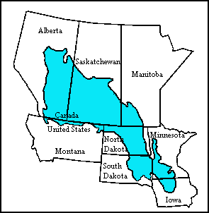
The Prairie Pothole Region is an expansive area of the northern Great Plains that contains thousands of shallow wetlands known as potholes. These potholes are the result of glacier activity in the Wisconsin glaciation, which ended about 10,000 years ago. The decaying ice sheet left behind depressions formed by the uneven deposition of till in ground moraines. These depressions are called potholes, glacial potholes, kettles, or kettle lakes. They fill with water in the spring, creating wetlands, which range in duration from temporary to semi-permanent. The region covers an area of about 800,000 sq. km and expands across three Canadian provinces and five U.S. states. The hydrology of the wetlands is variable, which results in long term productivity and biodiversity. The PPR is a prime spot during breeding and nesting season for millions of migrating waterfowl.
Upo or UPO may refer to:

Lake Zahl National Wildlife Refuge is a 3,823-acre (1,547 ha) National Wildlife Refuge in Williams County in the U.S. state of North Dakota. The refuge consists of Lake Zahl which provides habitat for many species of waterfowl and other species. It is managed by the Crosby Wetland Management District.

Pablo de Olavide University is a public university in Seville, Spain. UPO offers both undergraduate and graduate programs in the traditional majors, as well as in biotechnology, environmental sciences, humanities, labor relations, second language acquisition, social work, sports sciences, and translation.
The Korea Federation for Environmental Movements (KFEM) is a non-profit organization in South Korea that focuses on environmentalism.
Mississippi Lake is a lake in Lanark County in Ontario, Canada. Ontario's Mississippi River flows northeast and north through the lake. Several small creeks including Cranberry Creek, McCrearys Creek, and McGibbon Creek drain into the lake from adjoining forest and agricultural land. The lake is distinctive for having one side that is part of the Canadian shield, while the other is mostly limestone. The lake is a remnant of the old Champlain Sea, which flooded eastern Ontario at the end of last ice age. The former shoreline of the sea can still be traced inland from the north shore of the lake.

Smith and Bybee Wetlands Natural Area is a public park and nature reserve between the Columbia Slough and the Columbia River in Portland, Oregon. At about 2,000 acres (810 ha), it is one of the largest urban freshwater wetlands in the United States. Metro, the regional government for the Oregon part of the Portland metropolitan area, manages the park. A covered shelter, restrooms, a paved walkway, and a canoe launch lie on the north side of the natural area.
The Mulwaree River, a perennial river that is part of the Hawkesbury-Nepean catchment, is located in the Southern Tablelands region of New South Wales, Australia.

Changnyeong-eup is a town (eup) in the administrative county of Changnyeong, South Gyeongsang Province, in South Korea.