Name State(s) Height Type River Coordinates Built ft m Oroville Dam [ 1] CA 770.5 234.8 Embankment Feather River 39°32′20″N 121°29′08″W / 39.53889°N 121.48556°W / 39.53889; -121.48556 (Oroville ) 1968 Hoover Dam [ 2] AZ NV 726 221 Arch-gravity dam Colorado River 36°00′56″N 114°44′16″W / 36.01556°N 114.73778°W / 36.01556; -114.73778 (Hoover ) 1936 Dworshak Dam [ 3] ID 717 219 Concrete gravity N.F. Clearwater River 46°30′54″N 116°17′49″W / 46.51500°N 116.29694°W / 46.51500; -116.29694 (Dworshak ) 1973 Glen Canyon Dam [ 4] AZ 710 220 Concrete arch Colorado River 36°56′15″N 111°29′04″W / 36.93750°N 111.48444°W / 36.93750; -111.48444 (Glen Canyon ) 1966 New Bullards Bar Dam CA 645 197 Concrete arch N. Yuba River 39°23′36″N 121°08′35″W / 39.39333°N 121.14306°W / 39.39333; -121.14306 (New Bullards Bar ) 1969 New Melones Dam CA 625 191 Embankment Stanislaus River 37°56′50″N 120°31′41″W / 37.94722°N 120.52806°W / 37.94722; -120.52806 (New Melones ) 1979 Mossyrock Dam WA 606 185 Concrete arch Cowlitz River 46°32′04″N 122°25′34″W / 46.53444°N 122.42611°W / 46.53444; -122.42611 (Mossyrock ) 1968 Shasta Dam CA 602 183 Concrete gravity Sacramento River 40°43′07″N 122°25′08″W / 40.71861°N 122.41889°W / 40.71861; -122.41889 (Shasta ) 1945 New Don Pedro Dam CA 585 178 Embankment Tuolumne River 37°41′58″N 120°25′15″W / 37.69944°N 120.42083°W / 37.69944; -120.42083 (New Don Pedro ) 1971 Hungry Horse Dam MT 564 172 Concrete arch S.F. Flathead River 48°20′30″N 114°00′51″W / 48.34167°N 114.01417°W / 48.34167; -114.01417 (Hungry Horse ) 1953 Grand Coulee Dam WA 550 170 Concrete gravity Columbia River 47°57′21″N 118°58′54″W / 47.95583°N 118.98167°W / 47.95583; -118.98167 (Grand Coulee ) 1942 Seven Oaks Dam CA 550 170 Embankment Santa Ana River 34°08′45″N 117°03′45″W / 34.14583°N 117.06250°W / 34.14583; -117.06250 (Seven Oaks ) 2000 Ross Dam WA 540 160 Concrete arch Skagit River 48°43′54″N 121°04′02″W / 48.73167°N 121.06722°W / 48.73167; -121.06722 (Ross ) 1949 Trinity Dam CA 538 164 Embankment Trinity River 40°48′04″N 122°45′48″W / 40.80111°N 122.76333°W / 40.80111; -122.76333 (Trinity ) 1962 Yellowtail Dam MT 525 160 Concrete arch Bighorn River 45°18′24″N 107°57′29″W / 45.30667°N 107.95806°W / 45.30667; -107.95806 (Yellowtail Dam ) 1967 Cougar Dam OR 519 158 Embankment S.F. McKenzie River 44°07′44″N 122°14′25″W / 44.12889°N 122.24028°W / 44.12889; -122.24028 (Cougar Dam ) 1964 Swift Dam WA 512 156 Embankment Lewis River 46°04′47″N 122°11′52″W / 46.07972°N 122.19778°W / 46.07972; -122.19778 (Swift Dam ) 1958 Flaming Gorge Dam UT 502 153 Concrete arch Green River 40°54′52″N 109°25′17″W / 40.91444°N 109.42139°W / 40.91444; -109.42139 (Flaming Gorge ) 1964 New Exchequer Dam CA 490 150 Concrete-faced rockfill Merced River 37°35′10″N 120°16′10″W / 37.58611°N 120.26944°W / 37.58611; -120.26944 (New Exchequer ) 1967 Fontana Dam NC 480 150 Concrete gravity Little Tennessee River 35°27′08″N 83°48′17″W / 35.45222°N 83.80472°W / 35.45222; -83.80472 (Fontana Dam ) 1944 Morrow Point Dam CO 468 143 Concrete arch Gunnison River 36°27′07″N 107°32′17″W / 36.45194°N 107.53806°W / 36.45194; -107.53806 (Morrow Point ) 1968 Detroit Dam OR 463 141 Concrete gravity North Santiam River 44°43′15″N 122°14′59″W / 44.72083°N 122.24972°W / 44.72083; -122.24972 (Detroit Dam ) 1953 Bath County Pumped Storage Station Upper Dam VA 460 140 Embankment Little Back Creek 38°13′32″N 79°49′27″W / 38.22556°N 79.82417°W / 38.22556; -79.82417 (Bath County Pumped Storage Station ) 1984 Anderson Ranch Dam ID 456 139 Embankment S.F. Boise River 43°21′27″N 115°26′55″W / 43.35750°N 115.44861°W / 43.35750; -115.44861 (Anderson Ranch ) 1950 Union Valley Dam CA 453 138 Embankment Silver Creek 38°51′55″N 120°26′30″W / 38.86528°N 120.44167°W / 38.86528; -120.44167 (Union Valley Dam ) 1963 Carters Dam GA 445 136 Embankment Coosawattee River 34°36′55.4″N 84°40′26″W / 34.615389°N 84.67389°W / 34.615389; -84.67389 (Carters Dam ) 1977 New Waddell Dam AZ 440 130 Embankment Agua Fria River 33°50′49″N 112°15′58″W / 33.84694°N 112.26611°W / 33.84694; -112.26611 (New Waddell Dam ) 1994 Pine Flat Dam CA 440 130 Concrete gravity Kings River 36°49′56″N 119°19′34″W / 36.83222°N 119.32611°W / 36.83222; -119.32611 (Pine Flat Dam ) 1954 Round Butte Dam OR 440 130 Embankment Deschutes River 44°36′11″N 121°16′40″W / 44.60306°N 121.27778°W / 44.60306; -121.27778 (Round Butte Dam ) 1964 Mud Mountain Dam WA 432 132 Embankment White River 47°08′24″N 121°55′55″W / 47.14000°N 121.93194°W / 47.14000; -121.93194 (Mud Mountain Dam ) 1948 O'Shaughnessy Dam CA 430 130 Concrete arch Tuolumne River 37°56′51″N 119°47′17″W / 37.94750°N 119.78806°W / 37.94750; -119.78806 (O'Shaughnessy Dam ) 1923(1938) Libby Dam MT 422 129 Concrete gravity Kootenai River 48°24′42″N 115°18′34″W / 48.41167°N 115.30944°W / 48.41167; -115.30944 (Libby Dam ) 1975 Brownlee Dam ID OR 420 130 Embankment Snake River 44°50′10″N 116°54′00″W / 44.83611°N 116.90000°W / 44.83611; -116.90000 (Brownlee Dam ) 1958 Owyhee Dam OR 417 127 Concrete arch Owyhee River 43°38′31″N 117°14′33″W / 43.64194°N 117.24250°W / 43.64194; -117.24250 (Owyhee Dam ) 1932 Mammoth Pool Dam CA 411 125 Embankment San Joaquin River 37°19′23″N 119°18′58″W / 37.32306°N 119.31611°W / 37.32306; -119.31611 (Mammoth Pool Dam ) 1959 Hell Hole Dam CA 410 120 Embankment Rubicon River 39°03′26″N 120°24′32″W / 39.05722°N 120.40889°W / 39.05722; -120.40889 (Hell Hole Dam ) 1966 Navajo Dam NM 402 123 Embankment San Juan River 36°48′01″N 107°36′45″W / 36.80028°N 107.61250°W / 36.80028; -107.61250 (Navajo Dam ) 1962 Blue Mesa Dam CO 390 120 Embankment Gunnison River 38°27′02″N 107°20′06″W / 38.45056°N 107.33500°W / 38.45056; -107.33500 (Blue Mesa Dam ) 1966 Summersville Dam WV 390 120 Rockfill Gauley River 38°13′18″N 80°53′23″W / 38.22167°N 80.88972°W / 38.22167; -80.88972 (Summersville Dam ) 1966 Lewiston Dam NY 389 119 Concrete gravity Niagara River 43°08′35″N 79°02′23″W / 43.14306°N 79.03972°W / 43.14306; -79.03972 (Lewiston Dam ) 1963 Diablo Dam WA 389 119 Concrete arch Skagit River 48°42′51″N 121°07′52″W / 48.71417°N 121.13111°W / 48.71417; -121.13111 (Diablo Dam ) 1930 Pyramid Dam CA 386 118 Embankment Piru Creek 34°38′39″N 118°45′50″W / 34.64417°N 118.76389°W / 34.64417; -118.76389 (Pyramid Dam ) 1970 Jocassee Dam SC 385 117 Embankment Keowee River 34°57′35″N 82°55′02″W / 34.95972°N 82.91722°W / 34.95972; -82.91722 (Jocassee Dam ) 1973 Pacoima Dam CA 365 111 Variable radius arch Pacoima Creek 34°20′05″N 118°23′47″W / 34.33472°N 118.39639°W / 34.33472; -118.39639 (Pacoima ) 1929 Theodore Roosevelt Dam AZ 357 109 Concrete arch Salt River 33°40′18″N 111°09′40″W / 33.67167°N 111.16111°W / 33.67167; -111.16111 (Theodore Roosevelt Dam ) 1911(1996) Arrowrock Dam ID 350 110 Concrete arch Boise River 43°35′44″N 115°55′20″W / 43.59556°N 115.92222°W / 43.59556; -115.92222 (Arrowrock Dam ) 1915 Buffalo Bill Dam WY 350 110 Concrete arch Shoshone River 44°30′06″N 109°11′03″W / 44.50167°N 109.18417°W / 44.50167; -109.18417 (Buffalo Bill Dam ) 1910 Jordanelle Dam UT 345 105 Embankment Provo River 40°35′52″N 111°25′26″W / 40.59778°N 111.42389°W / 40.59778; -111.42389 (Jordanelle Dam ) 1992 Pardee Dam CA 345 105 Gravity Mokelumne River 38°15′27″N 120°51′01″W / 38.25750°N 120.85028°W / 38.25750; -120.85028 (Pardee ) 1929 William L. Jess Dam OR 345 105 Embankment Rogue River 42°40′17″N 122°40′30″W / 42.67139°N 122.67500°W / 42.67139; -122.67500 (William L. Jess Dam ) 1976 Abiquiu Dam NM 340 100 Embankment Rio Chama 36°14′17″N 106°25′33″W / 36.23806°N 106.42583°W / 36.23806; -106.42583 (Abiquiu Dam ) 1963(1986) Boundary Dam WA 340 100 Concrete arch-gravity Pend Oreille River 48°59′14″N 117°20′51″W / 48.98722°N 117.34750°W / 48.98722; -117.34750 (Boundary Dam ) 1967 Castaic Dam CA 340 100 Embankment Castaic Creek 34°31′09″N 118°36′25″W / 34.51917°N 118.60694°W / 34.51917; -118.60694 (Castaic Dam ) 1973 Folsom Dam CA 340 100 Concrete gravity, American River 38°42′28″N 121°09′23″W / 38.70778°N 121.15639°W / 38.70778; -121.15639 (Folsom Dam ) 1956 Lucky Peak Dam ID 340 100 Embankment Boise River 43°31′42″N 116°03′11″W / 43.52833°N 116.05306°W / 43.52833; -116.05306 (Lucky Peak Dam ) 1955 San Vicente Dam CA 337 103 Roller-Compacted Concrete Off-stream 32°54′44″N 116°55′28″W / 32.91222°N 116.92444°W / 32.91222; -116.92444 (San Vicente Dam ) 1943 (2014) Ridgway Dam CO 333 101 Embankment Uncompahgre River 38°14′15″N 107°45′33″W / 38.23750°N 107.75917°W / 38.23750; -107.75917 (Ridgway Dam ) 1987 Salt Springs Dam CA 332 101 Rock-fill North Fork Mokelumne River 38°29′54″N 120°12′58″W / 38.49833°N 120.21611°W / 38.49833; -120.21611 (Salt Springs ) 1931 Alder Dam WA 330 100 Concrete arch Nisqually River 46°48′05″N 122°18′37″W / 46.80139°N 122.31028°W / 46.80139; -122.31028 (Alder Dam ) 1945 Hells Canyon Dam ID OR 330 100 Concrete gravity Snake River 45°14′41″N 116°41′54″W / 45.24472°N 116.69833°W / 45.24472; -116.69833 (Hells Canyon Dam ) 1967 Green Peter Dam OR 327 100 Concrete gravity M. Santiam River 44°27′07″N 122°32′49″W / 44.45194°N 122.54694°W / 44.45194; -122.54694 (Green Peter Dam ) 1967 Crystal Dam CO 323 98 Concrete arch Gunnison River 38°30′38″N 107°37′31″W / 38.51056°N 107.62528°W / 38.51056; -107.62528 (Crystal Dam ) 1976 Yale Dam WA 323 98 Embankment Lewis River 45°57′51″N 122°19′57″W / 45.96417°N 122.33250°W / 45.96417; -122.33250 (Yale Dam ) 1953 Parker Dam AZ CA 320 98 Concrete arch Colorado River 34°17′47″N 114°08′21″W / 34.29639°N 114.13917°W / 34.29639; -114.13917 (Parker Dam ) 1938 Tieton Dam WA 319 97 Embankment Tieton River 46°39′23″N 121°07′46″W / 46.65639°N 121.12944°W / 46.65639; -121.12944 (Tieton Dam ) 1925 Warm Springs Dam CA 319 97 Rolled-earth embankment Dry Creek 38°43′06″N 123°00′46″W / 38.71833°N 123.01278°W / 38.71833; -123.01278 (Warm Springs ) 1982 Friant Dam CA 319 97 Concrete gravity San Joaquin River 37°00′02″N 119°42′19″W / 37.00056°N 119.70528°W / 37.00056; -119.70528 (Friant Dam ) 1942 Olivenhain Dam CA 318 97 Concrete gravity off-stream 33°04′13″N 117°08′17″W / 33.07028°N 117.13806°W / 33.07028; -117.13806 (Olivenhain ) 2003 Watauga Dam TN 318 97 Rockfill Watauga River 36°19′25″N 82°07′22″W / 36.32361°N 82.12278°W / 36.32361; -82.12278 (Watauga Dam ) 1948 Donnells Dam CA 317 97 Concrete arch Middle Fork Stanislaus River 38°19′50″N 119°57′38″W / 38.33056°N 119.96056°W / 38.33056; -119.96056 (Donnells Dam ) 1958 Cherry Valley Dam CA 315 96 Earth and rock Cherry Creek 37°58′34″N 119°54′33″W / 37.97611°N 119.90917°W / 37.97611; -119.90917 (Cherry Valley ) 1956 Courtright Dam CA 315 96 Rock-fill Helms Creek 37°04′44″N 118°58′12″W / 37.07889°N 118.97000°W / 37.07889; -118.97000 (Courtright ) 1958 San Gabriel Dam CA 315 96 Embankment San Gabriel River 34°12′20″N 117°52′33″W / 34.20556°N 117.87583°W / 34.20556; -117.87583 (San Gabriel Dam ) 1939 Merwin Dam WA 313 95 Concrete arch Lewis River 45°57′24″N 122°33′18″W / 45.95667°N 122.55500°W / 45.95667; -122.55500 (Merwin Dam ) 1931 Upper Stillwater Dam UT 310 94 Concrete gravity Rock Creek 40°33′35″N 110°41′59″W / 40.55972°N 110.69972°W / 40.55972; -110.69972 (Upper Stillwater Dam ) 1987 Bartlett Dam AZ 309 94 Multiple arch buttress Verde River 33°49′05″N 111°37′54″W / 33.81806°N 111.63167°W / 33.81806; -111.63167 (Bartlett Dam ) 1939 Green Mountain Dam CO 309 94 Embankment Blue River 39°52′39″N 106°19′49″W / 39.87750°N 106.33028°W / 39.87750; -106.33028 (Green Mountain Dam ) 1942 Horse Mesa Dam AZ 305 93 Concrete arch Salt River 33°35′27″N 111°20′38″W / 33.59083°N 111.34389°W / 33.59083; -111.34389 (Horse Mesa Dam ) 1927 San Luis Dam CA 305 93 Embankment San Luis Creek 37°03′33″N 121°04′29″W / 37.05917°N 121.07472°W / 37.05917; -121.07472 (San Luis Dam ) 1967 Teton Dam [ n 1] ID 305 93 Embankment Teton River 43°54′35″N 111°32′31″W / 43.90972°N 111.54194°W / 43.90972; -111.54194 (Teton Dam ) 1976 Monticello Dam CA 304 93 Concrete arch Putah Creek 38°30′47″N 122°06′15″W / 38.51306°N 122.10417°W / 38.51306; -122.10417 (Monticello Dam ) 1957 Elephant Butte Dam NM 301 92 Concrete gravity Rio Grande 33°09′14″N 107°11′32″W / 33.15389°N 107.19222°W / 33.15389; -107.19222 (Elephant Butte Dam ) 1916 Gorge Dam WA 300 91 Concrete gravity Skagit River 48°41′52″N 121°12′30″W / 48.69778°N 121.20833°W / 48.69778; -121.20833 (Gorge Dam ) 1924 Smith Lake Dam AL 300 91 Embankment Sipsey Fork 33°56′31″N 87°06′21″W / 33.94194°N 87.10583°W / 33.94194; -87.10583 (Smith Lake Dam ) 1961 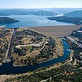 Oroville Dam, 1st
 Hoover Dam, 2nd
 Dworshak Dam, 3rd
 Hungry Horse Dam, 10th
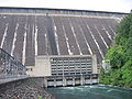 Fontana Dam, 20th


