Wachusett Dam

Last updated

Wachusett Dam
Wachusett-dam.jpg
Wachusett Dam at Clinton
Official nameWachusett Reservoir Dam
Location Clinton, Massachusetts, USA
Coordinates 42°24′13″N71°41′16″W / 42.40361°N 71.68778°W / 42.40361; -71.68778
Construction began1897;127 years ago (1897)
Opening date1905;119 years ago (1905)
Operator(s) MWRA
Dam and spillways
Impounds Nashua River
Height205 ft (62 m)
Length965 ft (294 m)
Reservoir
Creates Wachusett Reservoir
Wachusett Dam Historic District
USA Massachusetts location map.svg
Red pog.svg
Usa edcp location map.svg
Red pog.svg
Location Clinton, Massachusetts
Architect Shepley, Rutan and Coolidge; Olmsted Brothers
MPS Water Supply System of Metropolitan Boston MPS
NRHP reference No. 89002269 [1]
Added to NRHPJanuary 18, 1990

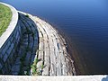
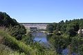
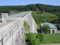
The Wachusett Dam in Clinton, Massachusetts, impounds the Nashua River, creating the Wachusett Reservoir. Construction started in 1897 [2] and was completed in 1905. It is part of the Nashua River Watershed.

Contents

This dam is part of greater Boston's water system, maintained and controlled by the Massachusetts Water Resources Authority (MWRA). Its discharge is into the Nashua River. When it was completed in 1905, the Wachusett Reservoir was the largest public water supply reservoir in the world. [2] At that time, the Wachusett Reservoir Dam was the largest gravity dam in the world as well.

Construction

The Metropolitan Water Board selected the south branch of the Nashua River in Clinton as the best site for Boston's new water supply over New Hampshire's Lake Winnipesaukee, Maine's Sebago Lake, and the Merrimack River. [2]

Churches, factories, homes, and schools within the valley had to be knocked down or moved. Roads and rail lines had to be relocated; a railroad tunnel and trestle had to be built in order to relocate the Central Massachusetts Railroad, and over four thousand bodies had to be dug up and moved in the local Catholic cemetery.[ citation needed ] The project brought thousands of immigrants to the area for work.

The dam created the world's largest water supply reservoir at the time. [2] It is still considered the largest "hand dug" dam in the world today.[ citation needed ]

Early problems

A static liquefaction flow failure occurred in the upstream slope of the North Dike of Wachusett Dam near Clinton, Massachusetts on April 11, 1907 during the first reservoir filling. The fine sands of the upstream dike shell liquefied and flowed approximately 100 meters horizontally into the reservoir.

See also

Related Research Articles

<span class="mw-page-title-main">West Boylston, Massachusetts</span> Town in Massachusetts, United States

West Boylston is a town in Worcester County, Massachusetts, United States and a northern suburb of Worcester. The population was 7,877 at the 2020 census. West Boylston includes the village of Oakdale, located on the opposite side of the Wachusett Reservoir from West Boylston center along Route 140. Although the town was split off from Boylston, it has a larger population than its eastern namesake.

<span class="mw-page-title-main">Clinton, Massachusetts</span> Town in Massachusetts, United States

Clinton is a town in Worcester County, Massachusetts, United States. The population was 15,428 at the 2020 census.

<span class="mw-page-title-main">Quabbin Reservoir</span> Massachusetts reservoir which serves the Boston area

The Quabbin Reservoir is the largest inland body of water in Massachusetts, and was built between 1930 and 1939. Along with the Wachusett Reservoir, it is the primary water supply for Boston, 65 miles (105 km) to the east, and 40 other cities and towns in Greater Boston. The Quabbin also supplies water to three towns west of the reservoir and acts as backup supply for three others. By 1989, it supplied water for 2.5 million people, about 40% of the state's population at the time. It has an aggregate capacity of 412 billion US gallons (1,560 GL) and an area of 38.6 square miles (99.9 km2).

<span class="mw-page-title-main">Massachusetts Water Resources Authority</span> American state public authority

The Massachusetts Water Resources Authority (MWRA) is a public authority in the Commonwealth of Massachusetts that provides wholesale drinking water and sewage services to 3.1 million people in sixty-one municipalities and more than 5,500 large industrial users in the eastern and central parts of the state, primarily in the Boston area.

<span class="mw-page-title-main">Nashua River</span> River in Massachusetts and New Hampshire, United States

The Nashua River, 37.5 miles (60.4 km) long, is a tributary of the Merrimack River in Massachusetts and New Hampshire in the United States. It is formed in eastern Worcester County, Massachusetts, at the confluence of the North Nashua River and South Nashua River, and flows generally north-northeast past Groton to join the Merrimack at Nashua, New Hampshire. The Nashua River watershed occupies a major portion of north-central Massachusetts and a much smaller portion of southern New Hampshire.

<span class="mw-page-title-main">Elephant Butte Dam</span> Dam on the Rio Grande in New Mexico, United States

Elephant Butte Dam or Elephant Butte Dike, originally Engle Dam, is a concrete gravity dam on the Rio Grande near Truth or Consequences, New Mexico. The dam impounds Elephant Butte Reservoir, which is used mainly for agriculture but also provides for recreation, hydroelectricity, and flood and sediment control. The construction of the dam has reduced the flow of the Rio Grande to a small stream for most of the year, with water being released only during the summer irrigation season or during times of exceptionally heavy snow melt.

<span class="mw-page-title-main">Wachusett Reservoir</span> Second largest body of water in the state of Massachusetts

The Wachusett Reservoir is the second largest body of water in the state of Massachusetts. It is located in central Massachusetts, northeast of Worcester. It is part of the water supply system for metropolitan Boston maintained by the Massachusetts Water Resources Authority (MWRA). It has an aggregate capacity of 65 billion US gallons (250,000,000 m3) and an area of almost 7 square miles (18 km2). Water from the reservoir flows to the covered Norumbega Storage Facility via the Cosgrove Tunnel and the MetroWest Water Supply Tunnel. The reservoir has a maximum depth of 120 feet (37 m) and a mean depth of 48 feet (15 m).

<span class="mw-page-title-main">Pathfinder Dam</span> Dam in Wyoming, USA

Pathfinder Dam is a masonry dam, located on the North Platte River, approximately 47 miles (76 km) southwest of Casper, Wyoming. It was originally constructed from 1905 to 1909 as part of the North Platte Project and has been modified several times since then. It is included on the National Register of Historic Places. Construction of the dam created Pathfinder Reservoir which provides water storage for 226,000 acres (910 km2) of irrigation in Wyoming and Nebraska. The dam is named for General John Charles Fremont, who had explored the area in 1842 and was nicknamed the "Pathfinder of the West."

<span class="mw-page-title-main">Ware River</span> River in United States of America

The Ware River is a 35.4-mile-long (57.0 km) river in central Massachusetts. It has two forks, its West Branch, which begins in Hubbardston, Massachusetts, and its East Branch, which begins in Westminster, Massachusetts. The Ware River flows southwest through the middle of the state, joins the Quaboag River at Three Rivers, Massachusetts, to form the Chicopee River on its way to the Connecticut River.

<span class="mw-page-title-main">Wachusett Aqueduct</span> Aqueduct in the Greater Boston area

The Wachusett Aqueduct is a secondary aqueduct that carries water from the Wachusett Reservoir to the John J. Carroll Water Treatment Plant at Walnut Hill in Marlborough, Massachusetts. It is part of the public water supply system for the communities of Greater Boston that are served by the Massachusetts Water Resources Authority (MWRA), which manages the aqueduct. The aqueduct serves as a standby backup to the Cosgrove Tunnel.

<span class="mw-page-title-main">Quinapoxet River</span> River

The Quinapoxet River is part of the Nashua River watershed in northern Massachusetts in the United States. It is part of the Massachusetts Water Resources Authority water system supplying drinking water to the greater Boston area.

<span class="mw-page-title-main">Stillwater River (Nashua River tributary)</span> River in the United States

The Stillwater River is part of the Nashua River watershed. This river is part of the Massachusetts Water Resources Authority system that supplies drinking water to the greater Boston area.

<span class="mw-page-title-main">1886 Mine Falls Gatehouse</span> United States historic place

The Mine Falls Gatehouse is a dam gatehouse in Mine Falls Park in Nashua, New Hampshire. It was built in 1886 by the Nashua Manufacturing Company to regulate water flow from the mill yard. The company relied on water flow to provide power to its mill. In 1987 the gatehouse was included in the Nashua Manufacturing Company Historic District and listed on the National Register of Historic Places as a contributing property.

<span class="mw-page-title-main">Frank E. Winsor</span>

Frank E. Winsor (1870-1939) was the chief engineer for the Boston Metropolitan District Water Supply Commission, now the Massachusetts Water Resources Authority, from 1926 until his death in 1939 and was closely involved in the design and construction of Winsor Dam and Goodnough Dike which were built by the Commission to create the Quabbin Reservoir in Massachusetts. Winsor Dam was named for him.

<span class="mw-page-title-main">Lake Cochituate</span> Reservoir in Middlesex County, Massachusetts

Lake Cochituate is a body of water in Natick, Wayland, and Framingham, Massachusetts, United States. Originally a reservoir serving Boston, it no longer serves that function, and is now a local recreational resource and home to Cochituate State Park.

<span class="mw-page-title-main">Wekepeke</span> Aquifer in the United States

Wekepeke is the name of an aquifer and brook in Sterling, Massachusetts, United States. The aquifer has a land surface area of 11.5 square miles (30 km2).

<span class="mw-page-title-main">Framingham Reservoir No. 1 Dam and Gatehouse</span> United States historic place

The Framingham Reservoir No. 1 Dam and Gatehouse is a historic water works facility in Framingham, Massachusetts. This complex is located at the end of Framingham Reservoir No. 1, which is also known as the Stearns Reservoir, off Winter Street and north of Long Avenue. Constructed from 1876 to 1878 as part of an expansion of the water supply of the city of Boston, this was designed by its first city architect George A. Clough. The historical purpose of the reservoir, which was located at the confluence of two branches of the Sudbury River, was primarily to control the river's water level, and secondarily to provide reserve supply capacity. The reservoir's reserve capacity was generally used only as a backup supply, as the reservoir's muddy bottom made it a less desirable source than reservoir No. 3 upstream. However the reservoir No. 1 system was nonetheless important due to its role in controlling the flow of the river downstream, and due to the gatehouse which controlled the water flows for all the Framingham reservoirs into the Sudbury Aqueduct. Reservoir No. 1 is no longer maintained as a reserve water source, although it is still owned by the Massachusetts Water Resources Authority, successor to the Boston Water Board which oversaw its construction. MWRA retains ownership as the gatehouse contains the connection between Reservoir No. 3 and the Sudbury Aqueudct which remain part of the emergency water systems.

<span class="mw-page-title-main">Framingham Reservoir No. 2 Dam and Gatehouse</span> United States historic place

The Framingham Reservoir No. 2 Dam and Gatehouse is a historic water works facility in Framingham, Massachusetts. The dam and gatehouse are located west of the junction of Winter and Fountain Streets, and impound a branch of the Sudbury River. The reservoir, which is also known as the Brackett Reservoir, was built 1877-79 as part of an expansion of the water supply of the city of Boston. The dam is 1,376 feet (419 m) in length, with a centered overfall area. The core of the dam is granite rubble laid in cement, with earthen embankments. The overfall area is faced on the downstream side with cut granite, and earthen embankment on the upstream side. It is topped with granite and originally had iron mounts for flashboards. The gatehouse is a rectangular granite structure with a steep hip roof, a brick chimney and an eyebrow dormer. The door and windows are in round-arch openings. It contains gate controls for regulating water flow from the reservoir and from a 4-foot (1.2 m) pipe connected to Reservoir No. 1, and a 2-foot (0.61 m) pipe connected to the Ashland Reservoir.

<span class="mw-page-title-main">Sudbury Dam Historic District</span> Historic district in Massachusetts, United States

The Sudbury Dam Historic District is a historic district on the southeastern end of Sudbury Reservoir off Massachusetts Route 30 in Framingham and Southborough, Massachusetts. The district encompasses the Sudbury Dam, which impounds the reservoir, and an area encompassing several historic structures located below the dam. The area includes water-supply-related structures from three phases of development of the Greater Boston water supply system. It was listed on the National Register of Historic Places in 1990.

<span class="mw-page-title-main">South Nashua River</span> River in the U.S. state of Massachusetts

The South Nashua River is a river in Massachusetts that flows 5.1 miles (8.2 km) through Clinton and Lancaster. It starts at the Wachusett Dam on the Wachusett Reservoir and ends by joining the North Nashua River to form the Nashua River.

References

  1. "National Register Information System". National Register of Historic Places . National Park Service. January 23, 2007.
  2. 1 2 3 4 History: Wachusett