
Portland Head Light is a historic lighthouse in Cape Elizabeth, Maine. The light station sits on a head of land at the entrance of the primary shipping channel into Portland Harbor, which is within Casco Bay in the Gulf of Maine. Completed in 1791, it is the oldest lighthouse in Maine. The light station is automated, and the tower, beacon, and foghorn are maintained by the United States Coast Guard, while the former lighthouse keepers' house is a maritime museum within Fort Williams Park.

Execution Rocks Light is a lighthouse in the middle of Long Island Sound on the border between New Rochelle and Sands Point, New York. It stands 55 feet (17 m) tall, with a white light flashing every 10 seconds. The granite tower is painted white with a brown band around the middle. It has an attached stone keeper's house which has not been inhabited since the light was automated in 1979.

The Oak Island Lighthouse is located in the Town of Caswell Beach near the mouth of the Cape Fear River in Southeastern North Carolina. It sits next to the Oak Island Coast Guard Station on the east end of Oak Island in Brunswick County looking south out at the Atlantic Ocean. Featuring four 2.5 million candlepower aerobeacon lenses which produce four, one-second bursts of light every 10 seconds, it has a luminous range of 24 nautical miles. Owned by the town since 2004, it is managed by a citizens group.
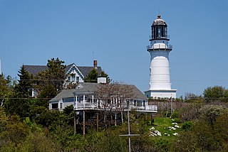
Cape Elizabeth Light is a lighthouse in Cape Elizabeth, at the southwestern entrance to Casco Bay in Maine.

Nobska Light, originally called Nobsque Light, also known as Nobska Point Light is a lighthouse located near the division between Buzzards Bay, Nantucket Sound, and Vineyard Sound in the settlement of Woods Hole, Massachusetts on the southwestern tip of Cape Cod, Massachusetts. It overlooks Martha's Vineyard and Nonamesset Island. The light station was established in 1826, with the tower protruding above the keeper's house, and was replaced in 1876 by the current 42 foot tall iron tower. The light station was added to the National Register of Historic Places as Nobska Point Light Station in 1987.

Ram Island Ledge Light is a lighthouse in Casco Bay, Maine, United States, marking the northern end of the main channel leading the harbor of Portland, Maine.

Nixes Mate, also known as Nixes Island, Nix's Mate and Nick's Mate, is one of the smaller islands in the Boston Harbor Islands National Recreation Area. Located in Boston Harbor's outer limits near the convergence of three major channels, the island lies about 5 nautical miles from downtown Boston and about 0.6 nautical miles east of Long Island Head Light. The island covers and uncovers with the tide and is not open to the public. It is described in the Light List as "Nixes Mate: black, white band midway of height, octagonal pyramid on square granite base", Light List number 1-11450.

Alcatraz Island Lighthouse is a lighthouse – the first one built on the U.S. West Coast – located on Alcatraz Island in California's San Francisco Bay. It is located at the southern end of the island near the entrance to the prison. The first light house on the island was completed in 1854, and served the bay during its time as a Citadel and military prison. It was replaced by a taller concrete tower built in 1909 to the south of the original one which was demolished after it was damaged due to earthquake in 1906. The automation of the lighthouse with a modern beacon took place in 1963, the year Alcatraz closed as the Alcatraz Federal Penitentiary. It is the oldest light station on the island with a modern beacon and is part of the museum on the island. Although when viewed from afar it easily looks the tallest structure on Alcatraz, it is actually shorter than the Alcatraz Water Tower, but as it lies on higher ground it looks much taller.
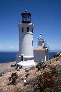
Anacapa Island Lighthouse is a lighthouse in California, United States, on the entrance to Santa Barbara Channel, California. Constructed in 1912, it was the last major light station built on the west coast. Anacapa and several other islands were collectively designated as Channel Islands National Monument in 1938, though the Coast Guard retained responsibility for the Anacapa lighthouse. Now fully automated and unmanned, the light house still operates, but the National Park Service (NPS) is responsible for Channel Islands National Park.

The Harbor of Refuge Light is a lighthouse built on the ocean end of the outer Delaware Breakwater at the mouth of the Delaware Bay, just off Cape Henlopen. It was built to function with the Delaware Breakwater East End Light in order to mark the National Harbor of Refuge.
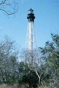
Cape Charles Lighthouse is an octagonal cast iron skeleton tower lighthouse at the mouth of the Chesapeake Bay on Smith Island which was officially removed from service in 2019. It is the tallest lighthouse in Virginia and the second tallest in the United States. This particular tower is the third lighthouse at this location. The first lighthouse at Cape Charles was a 55-foot (17 m) masonry tower completed in 1828. It was quickly deemed inadequate for its important seacoast location due to its low height and poor visibility at sea. It was soon threatened by erosion so in 1864 it was replaced by a 150-foot (46 m) masonry tower built further inland. Located a little more than a mile southwest of the old tower and 600 feet from the shoreline, the impressive 150-foot-tall conical brick tower was similar in appearance to the 1857 Cape May Lighthouse, painted white and topped with a dark brown lantern room. In 1892, a twenty-five-foot red band was painted around the white tower's midsection, about sixty feet up from the base, to make it more visible during the day. By the 1890s, it too was threatened by beach erosion which jetties built to protect it failed to halt, and with the lighthouse now only 300 feet from the ocean and the shoreline eroding at a rate of 37 feet per year it was decided that a third lighthouse needed to be built three quarters of a mile inland.

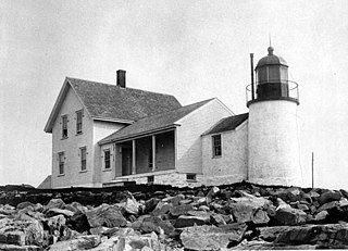
Goose Rocks Light is a sparkplug lighthouse located near North Haven, Maine in Penobscot Bay. It stands at the eastern entrance to the Fox Islands Thoroughfare, a busy mile-wide passage separating North Haven from Vinalhaven. Built in 1890, it was added to the National Register of Historic Places as Goose Rocks Light Station on January 21, 1988. The structure is now privately owned by a preservation group, and remains an active aid to navigation.

East Charity Shoal Light is an offshore lighthouse located near the Saint Lawrence River's entrance in northeastern Lake Ontario, due south of the city of Kingston, Ontario and approximately five miles (8 km) southwest of Wolfe Island. It is on the southeast rim of a 3,300-foot-diameter (1,000 m) submerged circular depression known as Charity Shoal Crater that may be the remnants of a meteorite impact.

Round Island Passage Light is an automated, unmanned 1948 lighthouse located in the Round Island Channel in the Straits of Mackinac, Michigan. The channel is a branch of Lake Huron.

Bear Island Light is a lighthouse on Bear Island near Mt. Desert Island, at the entrance to Northeast Harbor, Maine. It was first established in 1839. The present structure was built in 1889. It was deactivated in 1981 and relit as a private aid to navigation by the Friends of Acadia National Park in 1989. Bear Island Light was listed on the National Register of Historic Places as Bear Island Light Station on March 14, 1988.

Egg Rock Light is a lighthouse on Frenchman Bay, Maine. Built in 1875, it is one of coastal Maine's architecturally unique lighthouses, with a square tower projecting through the square keeper's house. Located on Egg Rock, midway between Mount Desert Island and the Schoodic Peninsula, it is an active aid to navigation, flashing red every 40 seconds. The light was listed on the National Register of Historic Places as Egg Rock Light Station in 1988.

Perkins Island Light is a lighthouse on the Kennebec River in Maine. It was established in 1898, as part of a major upgrade of the river's lights — the Doubling Point Light and the separate Range Lights on the point, Perkins Island Light, and Squirrel Point Light were all built at the same time. It was listed on the National Register of Historic Places as Perkins Island Light Station in 1988.
Winter Harbor Light is a lighthouse in Winter Harbor, Maine. It is located on Mark Island, a small island between the Schoodic Peninsula and Turtle Island, near the entry to the town's main harbor. The light was built in 1856 and was deactivated in 1933; it is no longer an aid to navigation, and is privately owned. The light was listed on the National Register of Historic Places as Winter Harbor Light Station on February 1, 1988.

Baker Island Light is a lighthouse on Baker Island, Maine, which is part of Acadia National Park. The light station was established in 1828 as a guide to the southern entrance to Frenchman Bay. The present tower was built in 1855; the well-preserved tower, keeper's house, and associated outbuildings were listed on the National Register of Historic Places in 1988.

Booby Island Light is an active heritage-listed lighthouse located on Booby Island in the Shire of Torres, near the tip of Cape York Peninsula, west of Prince of Wales Island, within the Endeavour Strait, Queensland, Australia. It marks the western entrance to the navigation channel through the Torres Strait. It was the last of the major lights to be constructed along the Queensland coast.


